
List of Massachusetts state forests facts for kids
Massachusetts is a state in the United States that loves its forests! A huge part of Massachusetts, about 59% of its land, is covered in trees. That's like having over 3 million acres (or 12,380 square kilometers) of green space!
These amazing forests, along with other natural areas like wildlife lands and places that protect water sources, are looked after by the state government. More than 500,000 acres (or 2,023 square kilometers) of this land is managed by different groups. These groups include the Department of Conservation and Recreation, which looks after state parks and recreation areas (about 285,000 acres or 1,153 square kilometers). The Division of Fisheries and Wildlife (MassWildlife) takes care of wildlife areas (about 140,000 acres or 567 square kilometers). And the Office of Watershed Management helps protect our water supply (about 104,000 acres or 421 square kilometers).
What are State Forests?
State forests are special areas of land owned and protected by the state government. They are managed to keep nature healthy, provide places for people to enjoy the outdoors, and sometimes even for sustainable timber harvesting. These forests are important for many reasons. They help clean our air, provide homes for animals, and protect our water.
Exploring Massachusetts State Forests
Massachusetts has many state forests spread across the state. These forests offer lots of fun activities for people of all ages. You can go hiking on trails, have a picnic, or even camp overnight in some areas. Many forests also have lakes or rivers where you can go fishing, kayaking, or swimming.
Some of the largest state forests include:
- October Mountain State Forest: This is the biggest state forest in Massachusetts, covering over 15,925 acres (6,444 hectares). It's located in the western part of the state.
- Myles Standish State Forest: Found in southeastern Massachusetts, this forest is also very large, with about 12,819 acres (5,188 hectares). It's known for its unique pine barrens habitat.
- Warwick State Forest: Located in northern Massachusetts, this forest spans 11,635 acres (4,708 hectares).
- Beartown State Forest: In the western part of the state, this forest covers 11,204 acres (4,534 hectares).
- Savoy Mountain State Forest: Another large forest in western Massachusetts, with 10,435 acres (4,223 hectares).
These forests are home to many different kinds of plants and animals. When you visit, you might see deer, foxes, various birds, and many types of trees like oaks, maples, and pines. It's a great way to connect with nature and learn about the environment around us.
See also
Images for kids
-
A sign welcoming visitors to Barnstable State Forest.
-
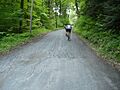
A view inside Beartown State Forest.
-
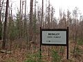
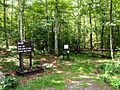
A sign at Berkley State Forest.
-
Dean Pond Recreation Area in Brimfield State Forest.
-
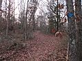
A path in Bryant Mountain State Forest.
-
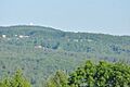
A view of Buckland State Forest.
-
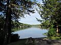
Laurel Lake in Erving State Forest.
-
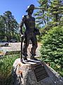
A statue of a Civilian Conservation Corps worker in Freetown-Fall River State Forest.
-
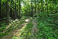
A trail in Rehoboth State Forest.


