
List of Pennsylvania state historical markers in Bradford County facts for kids

Welcome to Bradford County, Pennsylvania! This area is full of history, and you can discover many stories by visiting its special historical markers. These markers are like outdoor signs that tell you about important people, places, and events from the past.
The Pennsylvania Historical and Museum Commission (PHMC) has placed 46 of these official state historical markers across Bradford County. Each one shares a piece of Pennsylvania's rich history, from early settlements and Native American life to famous people and big changes. Let's explore some of the fascinating stories these markers tell!
Contents
Early Settlements and Unique Communities
Bradford County was home to some very interesting early communities.
French Azilum: A Royal Refuge
Imagine a place built for French royalty and nobles escaping danger! That's the story of Azilum, or "French Azilum." In the late 1700s, after the French Revolution, many French people, including those close to Queen Marie Antoinette, fled to America. They hoped to build a safe haven here.
Markers for Azilum can be found near Wyalusing. They tell about this unique settlement where French aristocrats tried to recreate a piece of their homeland in the Pennsylvania wilderness. It's a fascinating example of early immigration and how different cultures came together in America.
.jpg)

Wyalusing: A Town with Deep Roots
The town of Wyalusing has a long history, going back to Native American times. Later, it became an important early settlement for European newcomers. Markers in Wyalusing tell about its beginnings and how it grew over the years.

Native American Heritage and Ancient Paths
Long before European settlers arrived, Native American tribes lived in Bradford County. Their history is marked by important trails and significant sites.
Ancient Trails: Carrying Path and Warriors Path
Native Americans created many important trails across the land. The Carrying Path was one such trail, used for travel and trade. You can find a marker for it near the Chemung River Bridge in Athens.
Another vital route was the Warriors Path. This trail was used by Native American warriors and travelers for centuries. A marker for it is located near Wyalusing, reminding us of the ancient networks that crisscrossed the land. These paths were like the highways of their time!


Important Native American Sites
- Indian Hill: This site near Wyalusing was important during the American Revolution, especially for military actions involving Native American groups.
- Teaoga: Located in Athens, Teaoga was a significant Native American village. Markers here tell about its history and importance to the local tribes.
- Queen Esther's Town: This was another important Native American settlement, named after a Seneca leader. A marker near Milan tells its story.
The American Revolution in Bradford County
Bradford County played a role in the American Revolution, especially during the Sullivan Expedition.
Sullivan Expedition: A Military March
In 1779, during the Revolutionary War, General John Sullivan led an important military campaign against Native American tribes who were allied with the British. This was known as the Sullivan Expedition.
Several markers across Bradford County remember this event:
- Fort Sullivan: A fort was built in Athens during the expedition. Markers tell about its role in the war.
- Sullivan's March: Multiple markers trace the path of Sullivan's army through the county, including locations near Wyalusing and Ulster.
- Lime Hill: This area was also involved in military actions during the expedition.
These markers help us remember the challenges and conflicts of the Revolutionary War right here in Pennsylvania.

Famous People from Bradford County
Many notable individuals have connections to Bradford County, and their stories are told through historical markers.
Stephen Foster: A Musical Legend
Stephen Foster was a famous American songwriter, known for popular songs like "Oh! Susanna" and "Camptown Races." He spent time in Athens, Pennsylvania. Markers in Athens and Towanda celebrate his life and his contributions to American music.

Philip P. Bliss: Hymn Writer
Philip P. Bliss was a talented musician and composer, especially known for writing hymns and gospel songs. A marker in Rome, Pennsylvania, honors his life and his impact on religious music.

David Wilmot: A Voice for Change
David Wilmot was an important politician from Towanda. He was a U.S. Congressman and played a key role in debates about slavery in the 1800s. Markers in Towanda tell about his life and his efforts to shape the nation's future.

Lester Frank Ward: A Pioneer in Science
Lester Frank Ward was a groundbreaking scientist and sociologist. He is considered one of the founders of American sociology. A marker in Myersburg celebrates his life and his contributions to understanding society.

Local Towns and Modern History
Bradford County's towns have their own unique stories, and some markers highlight more recent developments.
Athens: A Historic Hub
Athens is a town with a rich past, from its Native American roots as Teaoga to its role in the American Revolution. Markers here tell about its early settlement and its importance as a community.
.jpg)
Camptown: Home of a Famous Race
The small town of Camptown is famous because of Stephen Foster's song, "Camptown Races." Markers in the area celebrate this connection to music and local history.

Rural Electrification: Bringing Power to Farms
In the 1930s, many rural areas in America did not have electricity. The Rural Electrification Administration (REA) was created to bring power to farms and remote homes. A marker near Wysox tells about this important effort that changed daily life for many people in Bradford County.

Images for kids
-
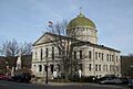
The Bradford County Courthouse in Towanda.
-

A placeholder image for a marker.
-
A placeholder image for a marker.
-
A placeholder image for a marker.
-
A placeholder image for a marker.
-
A placeholder image for a marker.
-
A placeholder image for a marker.
-
A placeholder image for a marker.
-
A placeholder image for a marker.
-
A placeholder image for a marker.
-
A placeholder image for a marker.
-
A placeholder image for a marker.
-
A placeholder image for a marker.
-
A placeholder image for a marker.
-
A placeholder image for a marker.
-
A placeholder image for a marker.
-
A placeholder image for a marker.
-
A placeholder image for a marker.
-
A placeholder image for a marker.
-
A placeholder image for a marker.
-
A placeholder image for a marker.
-
A placeholder image for a marker.
-
A placeholder image for a marker.
-
A placeholder image for a marker.
-
A placeholder image for a marker.
-
A placeholder image for a marker.
-
A placeholder image for a marker.
-
A placeholder image for a marker.
-
A placeholder image for a marker.
-
A placeholder image for a marker.
-
A placeholder image for a marker.
-
A placeholder image for a marker.
-
A placeholder image for a marker.
-
A placeholder image for a marker.
-
A placeholder image for a marker.
-
A placeholder image for a marker.
-
A placeholder image for a marker.
-
A placeholder image for a marker.
-
A placeholder image for a marker.
-
A placeholder image for a marker.
-
A placeholder image for a marker.
-
A placeholder image for a marker.
-
A placeholder image for a marker.
-
A placeholder image for a marker.
-
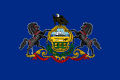
The flag of Pennsylvania.
-
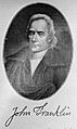
A portrait of Colonel John Franklin.


See also
- List of Pennsylvania state historical markers
- National Register of Historic Places listings in Bradford County, Pennsylvania
