
List of Pennsylvania state historical markers in Lehigh County facts for kids

Welcome to Lehigh County, Pennsylvania! This area is full of history, and you can learn about it by visiting special signs called state historical markers. These markers are placed by the Pennsylvania Historical and Museum Commission (PHMC) to tell us about important people, places, and events that happened right here.
There are 29 of these historical markers in Lehigh County. Each one shares a little piece of the past, helping us understand how the county grew and changed over time. Let's explore some of these cool historical spots!
Contents
Exploring Lehigh County's History Through Markers
Allentown: A City's Story


Allentown is the biggest city in Lehigh County, and it has several historical markers! These markers tell us about the city's beginnings, its growth in business and industry, and its role in government. Allentown was founded in the 1700s and quickly became an important center for trade and manufacturing. You can find markers about Allentown on different roads, showing how the city expanded over the years. They remind us of the city's long journey from a small settlement to the bustling place it is today.
Industrial Power: Iron, Cement, and Silk
Lehigh County played a huge part in Pennsylvania's industrial past. Many markers celebrate the businesses and inventions that shaped the region.
The Mighty Iron Works

In Catasauqua, you'll find markers for the Crane Iron Works and David Thomas. David Thomas was an important industrialist who helped start the Crane Iron Works in the 1840s. This company was a pioneer in making iron using anthracite coal, which was a big deal at the time! It helped the iron industry grow a lot. Another important iron site is the Lock Ridge Iron Furnace in Alburtis. These furnaces were like giant ovens that melted iron ore to make new metal products. They were very important for building things like railroads and bridges.
First Cement and Slate

Did you know that the first cement in America was made right here? A marker for First Cement is located near Coplay. This invention was super important for building roads, bridges, and buildings all over the country. Another key industry was slate. The First School Slate Factory in Slatington tells the story of how slate was used to make blackboards and writing slates for schools. The Slate Industry marker also highlights how this natural resource brought many workers to the area, including immigrants who helped build the community.
Dery Silk Mill
The Dery Silk Mill in Catasauqua is another marker showing the county's diverse industries. This mill was a major producer of silk, a fancy fabric, and provided many jobs in the early 1900s. It's a reminder of the different types of factories that once thrived in Lehigh County.
Early Settlements and Forts
Lehigh County has a rich history of early settlements and defenses.
Emmaus: A Moravian Town

The town of Emmaus has a marker that tells about its founding by the Moravians, a religious group, in the mid-1700s. It also mentions the Native American people who lived in the area before the European settlers arrived. Emmaus was an important early community in the region.
Forts of the French and Indian War
During the French and Indian War (1754-1763), several forts were built in Pennsylvania to protect settlers. In Lehigh County, you can find markers for Fort Deshler and Fort Everett. These forts were small defensive outposts that played a role in protecting the frontier during a time of conflict. They remind us of the challenges faced by early settlers.
Historic Homes and Quarries
The Troxell-Steckel House in Egypt is a very old house that shows us what homes looked like for early settlers. It's a great example of early Pennsylvania German architecture. Another interesting spot is the Indian Jasper Quarries near Vera Cruz. This was a place where Native Americans gathered jasper, a type of rock, to make tools and weapons thousands of years ago. It shows us how long people have lived and worked in this area.
Important People and Their Legacies
Many historical markers honor individuals who made a difference.
Revolutionary War Heroes
Frederick Leaser has a plaque near Leaser Lake Park. He was a local hero during the American Revolution, known for helping to transport the Liberty Bell to Allentown to keep it safe from the British. Another important figure is George Taylor, whose marker is in Catasauqua. George Taylor was one of the signers of the Declaration of Independence, a very important document that declared America's freedom from Great Britain.
Harriet A. Baker: A Woman of Faith

In Allentown, you can find a marker for Harriet A. Baker. She was an important African American woman who founded the first African Methodist Episcopal Church in Allentown. Her work was very important for the African American community and for religious life in the city.
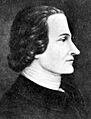
Stephen Vincent Benét: A Famous Writer
A marker in Fountain Hill honors Stephen Vincent Benét, a famous American writer. He won a Pulitzer Prize for his epic poem "John Brown's Body." His marker reminds us of the creative talent that has come from or lived in Lehigh County.
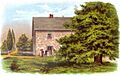
Trout Hall: A Historic Home
Trout Hall in Allentown is another historic building with its own marker. It was built in the 1770s and has connections to important early leaders and religious figures. It's a beautiful example of 18th-century architecture and a window into the lives of early prominent citizens.
These historical markers are like outdoor museums, each one telling a unique story about Lehigh County's past. They help us connect with history and understand the people and events that shaped our world.
Images for kids
-
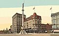
The Soldiers and Sailors Monument in Allentown
-
The 8th Street Bridge in Allentown, built in 1912
-
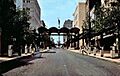
Hamilton Mall in Allentown in 1974
-
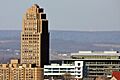
The skyline of Allentown, Pennsylvania
-
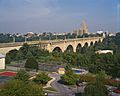
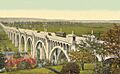
The South Eighth Street Viaduct in Allentown
-
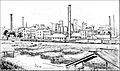
The Crane Iron Works in Catasauqua
-
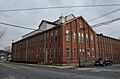
The Dery Silk Mill in Catasauqua
-
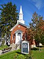
The Fourth Street Church in Emmaus
-
Fort Deshler in 1895
-
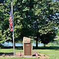
The Frederick Leaser Monument at Leaser Lake
-
George Taylor, a signer of the Declaration of Independence
-
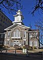
The Old Courthouse in Allentown, Lehigh County
-
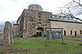
The Lock Ridge Furnace Complex
-
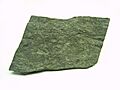
A close-up of slate
-
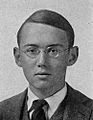
Stephen Vincent Benét during his time at Yale College
-

Trout Hall in Allentown
-
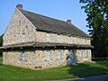
The Troxell-Steckel House


.jpg)


See also
- List of Pennsylvania state historical markers
- National Register of Historic Places listings in Lehigh County, Pennsylvania
