
List of State Register of Heritage Places in the Shire of Northampton facts for kids
The State Register of Heritage Places is like a special list of important buildings and sites in Western Australia. It's looked after by the Heritage Council of Western Australia. As of 2023, there are 223 places in the Shire of Northampton that are considered heritage sites. Out of these, 30 are so important that they are on the State Register of Heritage Places.
Contents
Discovering Northampton's Historic Places
Northampton is a town with a rich history, and many of its old buildings and sites are protected. These places tell us stories about how people lived, worked, and built their communities long ago. Let's explore some of these fascinating heritage sites.
Old Mining and Smelting Sites
Northampton was once a busy mining area, especially for lead. You can still see the remains of these early industries.
Warribanno Smelter Complex Ruin
The Warribanno Smelter Complex Ruin is a very old site near Ajana. It was built in 1849. This is where they used to melt down (smelt) lead ore from the mines. Today, you can see the chimney and other ruins. It reminds us of the early mining days in the region. This site was added to the State Register on 13 December 1996.
Geraldine Lead Mine Site
Also near Ajana is the Geraldine Lead Mine Site. This mine started in 1849. It was one of the first lead mines in Western Australia. The site includes old buildings and even a graveyard. It shows how important mining was to the area's growth. It became a registered heritage place on 4 August 1998.
Wanerenooka Mine Site
The Wanerenooka Mine Site is located right in Northampton. Mining began here in 1855. This site is a key part of Northampton's mining past. It was added to the State Register on 1 April 1999.
Northampton State Battery
The Northampton State Battery, built in 1954, is another important mining heritage site. It's where ore was crushed to extract valuable minerals. It became a registered heritage place on 2 June 1998.
Historic Buildings and Churches
Many of Northampton's old buildings show the town's development and its community spirit.
Church and Cemetery, Gwalla
The Church and Cemetery at Gwalla, in Northampton, dates back to 1861. This site includes a church and a cemetery. It tells us about the early settlers and their spiritual life. It was registered on 27 December 2002. The Gwalla Cemetery itself was established in 1863.
Former Convent of the Sacred Heart
The former Convent of the Sacred Heart, also known as the Nagle Centre, is in Northampton. It was built in 1919. Convents were places where nuns lived and often ran schools. This building is a reminder of the role of education and faith in the community. It was registered on 26 February 1999.
Church of Our Lady in Ara Coeli
This church, sometimes called St Mary's, is a beautiful building in Northampton. It was built in 1936. Churches often become central parts of a town's history and community life. It was added to the State Register on 28 February 1995.
Holy Trinity Anglican Church
The Holy Trinity Anglican Church in Northampton was built in 1908. It's another example of the important religious buildings in the area. This church became a registered heritage place on 15 August 2003.
Former Northampton Police Station and Court House
This building, located at 202 Hampton Road in Northampton, was built in 1884. It served as the police station, living quarters for officers, and the court house. It shows how law and order were managed in the early days. It was registered on 30 October 1998.
Former Northampton Roads Board Building
Built in 1898, this building at 53 Hampton Road in Northampton was once the office for the local government. It's also been used as a public library. It represents the early administration of the town. It was registered on 9 September 2003.
Important Homesteads and Depots
Beyond the town, there are also historic farms and depots that played a big role in the region's development.
Lynton Convict Hiring Depot (Ruins)
The Lynton Convict Hiring Depot, near Yallabatharra, was built in 1853. This was a place where convicts were brought to work on farms and in mines. It's a significant site that tells us about the convict era in Western Australia. It was registered on 2 June 1995. Parts of this site include the Lynton Barns & Stables and Sanford's House.
Chiverton House Complex
The Chiverton House Complex in Northampton was built in 1865. Homesteads like this were the heart of large farming properties. They show the lifestyle of early settlers. It was registered on 11 August 1995.
The Bowes
"The Bowes" is a historic property near East Bowes, built in 1850. It's also known by names like Chilimony Bowes. This homestead is an important part of the agricultural history of the region. It was registered on 6 September 1996.
Oakabella
Oakabella, built in 1860, is another significant homestead near Bowes. These old farmhouses and their outbuildings give us a glimpse into the past. It was registered on 28 June 1996.
Brookside, Hillview & Surrounds
This group of properties, including Brookside and Hillview, near Northampton, dates back to 1877. These sites show how farming communities grew and developed over time. They were registered on 25 June 2004.
Railway History
The railway played a crucial role in connecting Northampton to other towns and ports.
Northampton Railway Station Precinct
The Northampton Railway Station Precinct, built in 1912, is a key part of the town's transport history. It includes the station building, a rest room, and the Station Master's House. It also has the site of an old wheat bin, weighbridge, and railway turntable. This whole area shows how important the railway was for moving goods and people. It was registered on 15 January 2013.
Images for kids
-
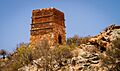
The Warribanno Smelter Complex Ruin, built in 1849.
-
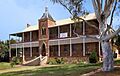
The former Convent of the Sacred Heart, built in 1919.
-
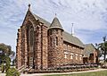
The Church of Our Lady in Ara Coeli, built in 1936.
-
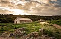
The ruins of the Lynton Convict Hiring Depot, established in 1853.


