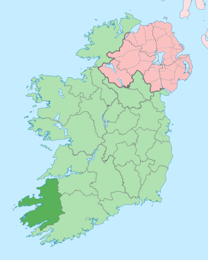
List of castles in County Kerry facts for kids
County Kerry in Ireland is famous for its many old castles and forts. These amazing structures tell stories of the past. This article will help you learn about some of these cool places. It will also show you how to find them using special maps.
Contents
Finding Castles and Forts on Maps
The information about these castles and forts comes from a TV series and special maps. These maps are made by Ordnance Survey, which is Ireland's national map-making group. Most of the castles and forts listed are easy to find on the maps. Many of them are also open for you to visit!
The maps used are called "Discovery Series" maps. They are very detailed. Older maps might have a different scale, like 1:126,720. Newer maps are often at a scale of 2 centimetres to 1 kilometre. This means 2 cm on the map equals 1 km in real life. These maps are updated often, with new versions coming out over the years.
Map Sheets for County Kerry
Here are the main map sheets that cover County Kerry:
- O.S. Sheet 63 - Covers North West Kerry and the Shannon Estuary, near Listowel.
- O.S. Sheet 64 - Covers North East Kerry, near Tarbert and Newcastlewest.
- O.S. Sheet 70 - Shows the Dingle Peninsula.
- O.S. Sheet 71 - Covers Tralee and Tralee Bay.
- O.S. Sheet 72 - Shows the borders of Cork, Kerry, and Limerick.
- O.S. Sheet 78 - Covers South Kerry, Killarney, and Kenmare.
- O.S. Sheet 79 - Shows South East Kerry and the Cork/Kerry borders.
- O.S. Sheet 83 - Covers Caherciveen and Valentia Island.
- O.S. Sheet 84 - Shows the Kenmare River area.
- O.S. Sheet 85 - Covers South Kerry, near Bantry.
Understanding the Castle Information
When you look at lists of castles and forts, you'll see different pieces of information. Here's what some of the terms mean:
- Structure: This tells you what kind of building it is. It could be a "Castle" or a "Promontory Fort." Sometimes you might see "Dun Cinn Tire" or "Signal Tower."
- O.S. Sheet: This is the number of the Ordnance Survey map sheet where you can find the place.
- N.G. Segment: This stands for "National Grid Segment." It's like a small square on the map. Each segment is 1 square kilometre in size.
- V (Vertical) and H (Horizontal): These are numbers that help you find the exact spot on the map. Think of it like playing "Battleship"! The "V" is for the vertical line (North-South) and "H" is for the horizontal line (East-West). The castle will be in the square just to the northeast of where these lines cross.
- Type: This gives more details about the structure:
- Castle: These were usually built by the Celts or Normans a long time ago.
- Promontory Fort: These are very old forts, often built around 1500 BC. They are usually found on a piece of land that sticks out into the sea.
- Dun Cinn Tire: This is the Irish name for "Promontory Fort."
- Signal Tower: These towers were likely built by the Normans. They were used to send signals, perhaps with fires or flags.
- Near: This tells you a well-known place nearby, like a town, village, or a famous landmark. This helps you get your bearings.
- Comment: This section gives extra notes. It might tell you the nearest main road (like N 22 or R 559). It also says if the place is easy to get to or if you can see it from the road.
- Marked Y/N: This tells you if the castle or fort is still clearly marked on the map (Y for Yes) or if it's gone (N for No). Sometimes, even if a castle is gone, its location is still important for history. For example, Tralee Castle is no longer there, but its historical spot is still noted.
Examples of Castles and Forts
County Kerry has many amazing historical sites. Here are just a few examples of the types of structures you can find:
- Gallarus Castle: This castle is found on O.S. Sheet 70, near Murreaght. It's close to the R 559 road.
- Ballinskelligs Castle: Located near the town of Ballinskelligs.
- Ballycarbery Castle: You can find this castle near Caherciveen, just off the N 70 road.
- Ross Castle: This famous castle is right by Killarney, a popular town.
- Straigue Fort: This is a cool stone fort near Caherdaniel.
- Tralee Castle: While the original castle in Tralee town center is no longer standing, its historical importance means its location is still noted.
These old buildings are a great way to learn about the history of Ireland and the people who lived there long ago!
 | Ernest Everett Just |
 | Mary Jackson |
 | Emmett Chappelle |
 | Marie Maynard Daly |


