
List of churches in Cambridge facts for kids
Cambridge is a historic city in England, famous for its university and many beautiful buildings. Among these are its many churches and chapels, which have played a big part in the city's history for hundreds of years. These buildings are used for worship, but they are also important landmarks and examples of amazing architecture.
Contents
Active Churches and Chapels
Cambridge has many churches that are still used today. They belong to different Christian groups, and some are very old while others are quite new.
Church of England Churches
Many churches in Cambridge are part of the Church of England.
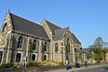
- Christ Church: This church was built between 1837 and 1839. In 2004, it welcomed a new group of worshippers from another church called St Andrew the Great.
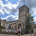
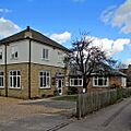
- Christ the Redeemer: This church is a mix of Church of England and Methodist traditions. It was formed in 2004 when two older churches, Meadowlands Methodist Church and Holy Cross, joined together.
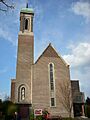
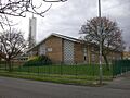
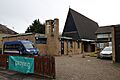
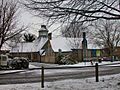
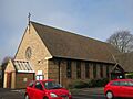
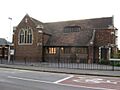
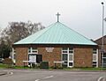
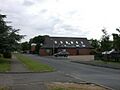
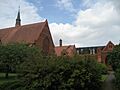
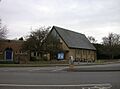
- The Good Shepherd: Built in 1958, this church serves the community in the Arbury area of Cambridge.
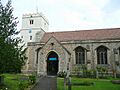
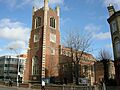
- Holy Trinity: This church has a very long history, founded way back in 1189! It's been a place of worship for over 800 years.
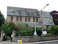
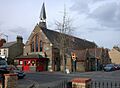
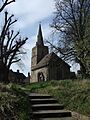
- St Andrew's, Cherry Hinton: This church dates back to around 1200. It's located in the village of Cherry Hinton, which is now part of Cambridge.
- St Andrew's, Chesterton: Also founded around 1200, this church is in the Chesterton area of Cambridge.
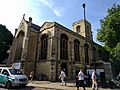
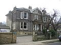
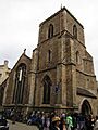
- St Andrew the Great: The original medieval church here was pulled down in 1842 and rebuilt in the Victorian style. Since 1994, it has been home to the congregation from Holy Sepulchre church.
- St Augustine of Canterbury: This church is part of a group of churches called the 'Church at Castle' partnership.
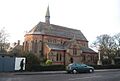
- St Barnabas: Built in 1869, St Barnabas is another active Church of England church in Cambridge.
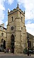
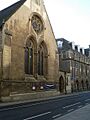
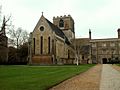
- St Bene't's: This is a very special church because it's the oldest church in Cambridgeshire and the oldest building still standing in Cambridge! It was founded around 1020.
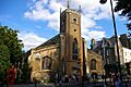
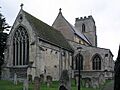
- St Botolph's: This church was founded around 1350.
- St Clement's: Dating back to about 1225, St Clement's is another historic Church of England church.
- St Edward King and Martyr: Founded around 1250 and rebuilt in 1400, this church has a special connection to the Royal family, known as a 'Royal Peculiar'.
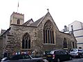
- St Giles': Founded in 1092, St Giles' is one of the oldest churches in Cambridge and is also part of the 'Church at Castle' partnership.
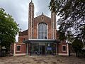
- St George: This church was built in 1938.
- St James: Founded in 1955, St James is a more modern Church of England church.
- St John the Evangelist: This church was built in 1891.
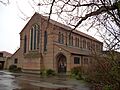
- St Luke's: This church is a "Local ecumenical partnership," meaning it combines both United Reformed Church (URC) and Church of England traditions. The current building was put up between 1873 and 1874. It's also part of the 'Church at Castle' partnership.
- St Mark's: Built in 1870, St Mark's had a smaller wooden building on its site until 1901.
- St Martin's: Services for St Martin's took place in temporary buildings until the current church was built in 1961.
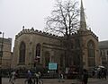
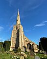
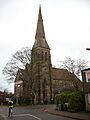
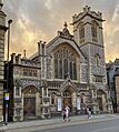
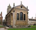
- St Mary the Great: Founded in 1205, this is a very important church in Cambridge.
- St Mary the Less: Built in 1352, this church is also known as Little St Mary's.
- SS Mary and Michael: Located in Trumpington, this church was built between 1200 and 1330.
- St Matthew's: Founded in 1866, St Matthew's also received a group of worshippers from St Andrew the Great in 2008.
- St Paul's: This church was built in 1841.
- St Philip's: Founded in 1889, St Philip's is another active Church of England church.
- St Thomas's Hall: Built in 1980, this hall is part of St Martin's parish and is regularly used for services.
Other Denominations
Cambridge is home to churches from many other Christian denominations.
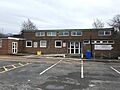
- The Church of Jesus Christ of Latter-day Saints: This church was built in 1965.
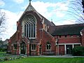
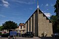
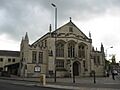
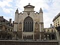
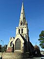
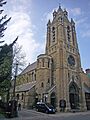
- Our Lady and the English Martyrs: This large Catholic church was built between 1885 and 1890. It's a very grand building.
- St Laurence's: This Catholic church was founded in 1947, with its permanent building completed in 1958.
- St Philip Howard: This Catholic church was built in 1978.
- St Vincent de Paul: Founded in 1958, the current building for this Catholic church was actually the old St Laurence's church, moved to its new location in Ditton Lane.
- Fisher House University Catholic Chaplaincy: This Catholic chaplaincy for university students was founded in 1925.
- St Athanasios: This is a Greek Orthodox church, founded in 1902. The building used to be the Cherry Hinton Road United Reformed Church.
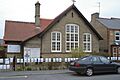
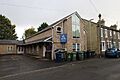
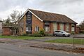
- Arbury Road Baptist Church: Originally called the Ebenezer, this Baptist church moved to its current site in 1930, and a new chapel was built in 1966.
- Barnwell Baptist Church: Another Baptist church in Cambridge.
- Cherry Hinton Baptist Church: This Baptist church serves the Cherry Hinton area.
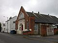
- Mill Road Baptist Church: This Baptist church was founded in 1881.
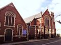
- St Andrew's Street Baptist Church: This Baptist church has been rebuilt several times since it was founded in 1721.
- Zion Baptist Church: Founded in 1837, this Baptist church was rebuilt in 1879.
- Eden Baptist Church: Originally a "Strict and Particular Baptist" chapel, this church was founded in 1823 and rebuilt in 1874 and 1982.
- Castle Street Methodist Church: Founded in 1823, this Methodist church is part of the 'Church at Castle' partnership. It has been rebuilt several times.
- Chesterton Methodist Church: Another Methodist church in Cambridge.
- Wesley Methodist Church: This Methodist church was founded in 1913.
- Downing Place United Reformed Church: This church was formed in 1687 from a merger of two older congregations. The current building dates from 1891.
- Jesus Lane Quaker Meeting House: The Quakers have had a meeting house here since 1776–77.
- Hartington Grove Quaker Meeting House: This Quaker meeting house was established in 1983.
- German Lutheran Church: This church serves the German Lutheran community in Cambridge.
- Cambridge Salvation Army: The Salvation Army has been active in Cambridge since 1914.
- Cambridge Seventh-Day Adventist Church: This church was founded in 1920, with its permanent building completed in 1962.
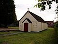
- North Arbury Chapel: This chapel was built in 1976.
- Roseford Chapel: This chapel was founded in 1959.
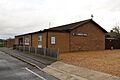
- Queen Edith Chapel: This chapel was founded around 1960.
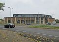
- King's Church Cambridge: This church is part of the Assemblies of God. The building was originally a Baptist chapel.
- C3 Church: Formerly known as Cambridge Community Church, this church built a new building around 2015 on the site of an older church.
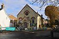
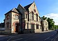
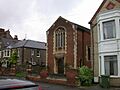
- Memorial Unitarian Church: This Unitarian church was founded in 1904, with its permanent building designed in 1927.
- Cambridge Chinese Christian Church: This interdenominational church uses a building that was originally the Castle End Mission, built in 1884.
- Christadelphian Hall: This hall for Christadelphians was built in 1954.
- City of David Church: This Pentecostal church was founded in 2005.
- First Church of Christ Scientist: The building for this Christian Science church shows the date 1866.
- Kingdom Hall: This is a meeting place for Jehovah's Witnesses.
College and School Chapels
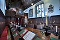
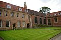
Many of Cambridge's famous colleges and schools have their own chapels. These are often very old and beautiful buildings.
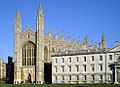
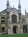
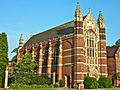
- King's College Chapel: This is one of the most famous buildings in Cambridge, known for its stunning architecture. It was built between 1446 and 1515.
- Queens' College Chapel: The chapel at Queens' College was first built in the 1450s and then rebuilt in a different part of the college in 1891.
- Christ's College Chapel: This chapel dates back to around 1440 and was made larger in 1510.
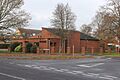
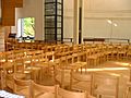
- Chapel at Churchill College: This interdenominational chapel was built in 1967.
- Clare College Chapel: The original chapel was built in 1363, rebuilt in 1535, and the current beautiful structure was built between 1763 and 1769.
- Corpus Christi College Chapel: Built in 1577, this college used to use St Bene't's church nearby before getting its own chapel. A new chapel was built in 1827.
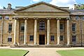
- Downing College Chapel: It took Downing College over 150 years to get its own purpose-built chapel, which was finally constructed between 1950 and 1953.
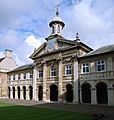
- Emmanuel College Chapel: The original chapel was part of a Dominican friary. The current chapel, designed by the famous architect Christopher Wren, was built in 1677.
- Fitzwilliam College Chapel: This interdenominational chapel was built in 1991.
- Girton College Chapel: This chapel was built between 1899 and 1902.
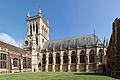
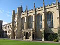
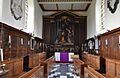
- Gonville and Caius College Chapel: Founded in 1393, this is the oldest college chapel in either Oxford or Cambridge that has been used continuously.
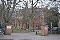
- Jesus College Chapel: This chapel is the oldest university building in Cambridge still in use! It was originally part of St Radegund's Priory before the college was founded around 1500.
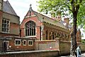
- Magdalene College Chapel: This chapel was built between 1470 and 1472.
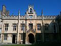
- Pembroke College Chapel: The original chapel, built around 1350, was the first chapel built specifically for a college in Cambridge. The current chapel was designed by Christopher Wren and opened in 1665.
- Peterhouse Chapel: Built in 1628, Peterhouse College used to use St Mary the Less as its chapel before this one was built.
- Robinson College Chapel: This interdenominational chapel was built in 1981.
- St Catharine's College Chapel: This chapel was rebuilt and re-opened in 1704.
- St Edmund's College Chapel: This Catholic college chapel was built in 1916.
- St John's College Chapel: The current chapel, built between 1866 and 1869, is the tallest building in Cambridge!
- Selwyn College Chapel: This chapel was built in 1895.
- Sidney Sussex College Chapel: Originally a friary building, this chapel was rebuilt in 1776.
- Trinity College Chapel: This large chapel was built between 1554 and 1567.
- Trinity Hall Chapel: This chapel was founded in 1366.
- Memorial Chapel, The Leys School: This Methodist chapel was built in 1905.
- Ridley Hall Chapel: This Church of England chapel was built after 1891.
- Wesley House Chapel: This Methodist chapel was built in 1930.
- Westcott House Chapel: This is a Church of England chapel.
- Westminster College Chapel: This United Reformed chapel was built between 1897 and 1899.
- Westfield House Chapel: This Lutheran chapel is also used by the local Resurrection Lutheran Church.
Churches from the Past
Some churches in Cambridge are no longer used for regular services, or they have been taken down.
Disused Churches
These churches are no longer active but still stand.
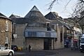
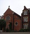
- Michaelhouse: Founded in 1324, this church stopped being used for regular services in 1908. It is now used as a cafe, but sometimes still holds services.
- St Peter's: Built around 1150, this church is now looked after by the Churches Conservation Trust. It's part of the 'Church at Castle' partnership.
- All Saints: The current building was rebuilt in 1863 but stopped being used in 1973. It's not used for Anglican services anymore.
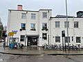
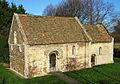
- Holy Sepulchre (The Round Church): Built in 1130, this unique round church is managed by Christian Heritage. Its congregation now meets at St Andrew the Great.
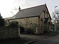
- Leper Chapel (Chapel of St Mary Magdalene): Founded around 1125, this is the oldest complete building still standing in Cambridge! It's no longer used for regular services and is looked after by the Cambridge Preservation Society.
- St Andrew The Less: Built in 1190, this church is rarely used for services today.
- Emmanuel United Reformed Church: This church was built in 1874 but closed in 2020. Its congregation joined another church, and the building now belongs to Pembroke College.
- Trumpington Free Church: Built in 1899, this church was formerly used by the C3 Church.
Demolished Churches
These churches no longer exist.
- All Saints by the Castle: This very old church, perhaps built before 1050, was abandoned around 1365 after the Black Death. Its ruins were still visible in 1635.
- St John Zachary: This church was destroyed around 1446 to make space for King's College Chapel. It was rebuilt nearby but was last recorded in 1488, as college buildings replaced houses in its parish.
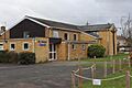
- St Stephen's: This church was built in 1962 but closed around 2010 and was taken down around 2015. The C3 Church now stands on its site.
Maps
Images for kids
-
Christ Church, Cambridge
-
Christ the Redeemer, Cambridge
-
The Church of the Good Shepherd, Arbury
-
Holy Trinity Church, Cambridge
-
St Andrew's Church, Cherry Hinton
-
St Andrew's Church, Chesterton
-
St Andrew the Great, Cambridge
-
St Augustine of Canterbury Church
-
St Barnabas Church, Cambridge
-
St Bene't's Church, Cambridge
-
St Botolph's Church, Cambridge
-
St Clement's Church, Cambridge
-
St Edward King and Martyr, Cambridge
-
St Giles' Church, Cambridge
-
St George Church, Cambridge
-
St James Church, Cambridge
-
The Church of Jesus Christ of Latter-day Saints
-
St John the Evangelist's Church, Cambridge
-
St Luke's United Reformed Church, Cambridge
-
St Mark's Church, Cambridge
-
St Martin's Church, Cambridge
-
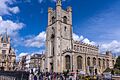
Church of St Mary the Great, Cambridge
-
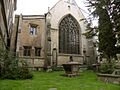
Church of St Mary the Less, Cambridge
-
SS Mary and Michael Church, Trumpington
-
St Matthew's Church, Cambridge
-
St Paul's Church, Cambridge
-
St Philip's Church, Cambridge
-
St Thomas's Hall, Cambridge
-

Our Lady and the English Martyrs Church
-
St Laurence's Church, Cambridge
-
St Philip Howard Church, Cambridge
-
St Vincent de Paul Church
-
Fisher House, Cambridge
-
St Athanasios Greek Orthodox Church
-
Arbury Road Baptist Church
-
Cherry Hinton Baptist Church
-
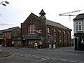
Mill Road Baptist Church
-
St Andrew's Street Baptist Church
-
Zion Baptist Church, Cambridge
-
Eden Baptist Church, Cambridge
-
Castle Street Methodist Church, Cambridge
-
Chesterton Methodist Church
-
Wesley Methodist Church, Cambridge
-
Downing Place United Reformed Church
-
Jesus Lane Quaker Meeting House
-
Hartington Grove Quaker Meeting House
-
German Lutheran Church, Cambridge
-
Cambridge Salvation Army
-
Cambridge Seventh-Day Adventist Church
-
North Arbury Chapel
-
Queen Edith Chapel, Cambridge
-
King's Church Cambridge
-
C3 Church, Cambridge
-
Memorial Unitarian Church, Cambridge
-
Cambridge Chinese Christian Church
-
First Church of Christ Scientist, Cambridge
-
King's College Chapel, Cambridge
-
Queens' College Chapel, Cambridge
-
Christ's College Chapel, Cambridge
-
Chapel at Churchill College, Cambridge
-
Clare College Chapel, Cambridge
-
Corpus Christi College Chapel, Cambridge
-
Downing College Chapel, Cambridge
-
Emmanuel College Chapel, Cambridge
-
Fitzwilliam College Chapel, Cambridge
-
Girton College Chapel, Cambridge
-
Gonville and Caius College Chapel, Cambridge
-
Jesus College Chapel, Cambridge
-
Magdalene College Chapel, Cambridge
-
Pembroke College Chapel, Cambridge
-
Peterhouse Chapel, Cambridge
-
Robinson College Chapel, Cambridge
-
St Catharine's College Chapel, Cambridge
-
St Edmund's College Chapel, Cambridge
-
St John's College Chapel, Cambridge
-
Selwyn College Chapel, Cambridge
-
Sidney Sussex College Chapel, Cambridge
-
Trinity College Chapel, Cambridge
-
Trinity Hall Chapel, Cambridge
-
Memorial Chapel, The Leys School
-
Ridley Hall Chapel, Cambridge
-
Wesley House Chapel, Cambridge
-
Westcott House Chapel, Cambridge
-
Westminster College Chapel, Cambridge
-
Westfield House Chapel, Cambridge
-
Michaelhouse, Cambridge
-
St Peter's Church, Cambridge
-
All Saints' Church, Cambridge
-
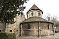
Holy Sepulchre (The Round Church), Cambridge
-
Leper Chapel, Cambridge
-
St Andrew The Less Church, Cambridge
-
Emmanuel United Reformed Church, Cambridge
-
Trumpington Free Church, Cambridge
-
St Stephen's Church, Cambridge (demolished)


.jpg)


.jpg)


.jpg)


.jpg)


.JPG)


.jpg)


