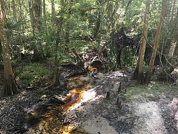
Lochloosa Creek facts for kids
Quick facts for kids Lochloosa Creek |
|
|---|---|

Lochloosa Creek, April 2019
|
|
| Country | United States |
| State | Florida |
| County | Alachua County |
| Physical characteristics | |
| Main source | Saluda Swamp 29°39′56″N 82°09′35″W / 29.66556°N 82.15972°W |
| River mouth | Lochloosa Lake 56 ft (17 m) 29°32′54″N 82°08′16″W / 29.54833°N 82.13778°W |
| Basin features | |
| Basin size | 42.7 sq mi (111 km2) |
| GNIS | 285900 |
Lochloosa Creek is a stream located in eastern Alachua County, Florida. It flows from the northern part of the county towards the south. This creek is very important to the area. It is the longest creek in Alachua County.
Lochloosa Creek is also the biggest stream that feeds into Lochloosa Lake. Its surrounding land, called a watershed, covers about 42.7 square miles. This area includes both natural lands and places used for growing trees.
Where Lochloosa Creek Begins
Lochloosa Creek starts its journey in a place called the Saluda Swamp. A swamp is a type of wetland with many trees and water. Here, the creek begins as a very small flow of water. It is just a tiny trickle.
From the Saluda Swamp, the creek flows south. As it moves, it passes through different types of land. Some of these areas are farms. These are called agricultural lands. The creek grows bigger as it collects more water along its path.
The Journey of the Creek
Lochloosa Creek travels through Alachua County. It is a key part of the local water system. The water from the creek eventually reaches Lochloosa Lake. This lake is a large body of water in Florida.
The creek's watershed is the entire area of land where water drains into the creek. This includes all the rain that falls on this land. The water then flows into Lochloosa Creek. This system helps keep the lake full and healthy.

