Los Artistas, Tamaulipas facts for kids
Quick facts for kids
Los Artistas Segunda Etapa
Los Artistas
|
||
|---|---|---|
|
||
 |
||
| Elevation | 164 m (538 ft) | |
| Population
(2010)
|
||
| • Total | 54 | |
| Time zone | UTC-6 (CST) | |
| • Summer (DST) | UTC-5 (CST) | |
| Codigo Postal |
88000
|
|
| Area code(s) | +52-867 | |
| Nearest Airports: Laredo: Laredo International Airport KLRD LRD Nuevo Laredo: Quetzalcoatl International Airport MMNL NLD | ||
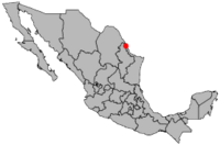
Los Artistas Segunda Etapa is a small community found in the Nuevo Laredo Municipality. This area is part of the Mexican state of Tamaulipas. It's a place where people live and form a small neighborhood.
About Los Artistas Segunda Etapa
Los Artistas Segunda Etapa is a community in northeastern Mexico. It is located in the state of Tamaulipas. This state is known for its long coastline along the Gulf of Mexico.
The community is part of the larger Nuevo Laredo Municipality. A municipality is like a local government area. It helps manage services for the people living there.
Population and Elevation
In 2010, a count of people called a census was done. This census showed that Los Artistas Segunda Etapa had 54 people living there. This makes it a very small community.
The community is located 164 meters above sea level. This means it is 164 meters higher than the ocean's surface. This elevation can affect the local weather and landscape.
Location in Tamaulipas
Tamaulipas is one of the 32 states that make up Mexico. It is in the northeastern part of the country. The state shares a border with the United States.
Nuevo Laredo is a major city in Tamaulipas. The municipality of Nuevo Laredo includes the city and surrounding areas. Los Artistas Segunda Etapa is one of these smaller areas.
See also
 In Spanish: Los Artistas (Tamaulipas) para niños
 | Sharif Bey |
 | Hale Woodruff |
 | Richmond Barthé |
 | Purvis Young |


