
Mapimí, Durango facts for kids
Quick facts for kids
Mapimí, Durango
|
|
|---|---|
|
City
|
|

Plaza de Armas and Church in Mapimí
|
|

Mapimí, Durango
Location in Durango

Mapimí, Durango
Location in Mexico
|
|
| Country | |
| State | Durango |
| Municipality | Mapimí |
| Settled | 25 July 1598 |
| Elevation | 1,305 m (4,280 ft) |
| Population
(2015)
|
|
| • Total | 5,623 |
| Postal code |
35200
|
| Area code(s) | 872 |
| Demonym | Mapimiense |
| Website | www.mapimi.gob.mx |
Mapimí is a city in the Mexican state of Durango. It is the main town of the Mapimí Municipality. In 2015, about 5,623 people lived there.
Near Mapimí, about 5 kilometers (3 miles) away, is the famous Ojuela Mine. This mine is well-known for its beautiful mineral specimens, especially a type of mineral called adamite.
History of Mapimí
When Spanish explorers first came to the Mapimí area in the late 1500s, different groups of Native Americans lived there. These included the Tepehuan, Tobosos, and Cocoyones. They were nomadic or semi-nomadic, meaning they moved around a lot.
Mapimí was founded on July 25, 1598. It was started by Agustin de Espinoza, a Jesuit priest, and Captain Antón de Zapata, a soldier. The settlement was first named Santiago de Mapimí. The name "Mapimí" comes from the Cocoyones people. They called the area "Mapeme," which means "high mountain." Like many early towns in Northern Mexico, Mapimí was settled because of the rich minerals found there.
The Toboso and other Native American groups sometimes fought against the Spanish settlements. They took part in wars in 1644, 1667, and 1684. Most of these Native American groups later joined the Spanish population in the 1700s.
Geography and Landscape

Mapimí is located in a large desert and mountain area called the Bolsón de Mapimí. This area is in northern Mexico. The Bolsón is a special type of basin. This means that no rivers flow out of it to the sea. Instead, any water stays within the basin, often forming shallow lakes.
The Mapimí Mountains, also known as the Sierra de Mapimí, rise up from the southern edge of the town. These mountains reach a height of 2,479 meters (8,133 feet). This highest point is about 6.5 kilometers (4 miles) southeast of Mapimí.
The Ojuela Mine and the Ojuela Bridge are also in these mountains. The Ojuela Bridge is a very high and long suspension bridge. It is located about 5 kilometers (3 miles) away on the eastern side of the mountains. About 100 kilometers (60 miles) north of Mapimí is the famous Mapimí Silent Zone. This area is part of the Mapimí Biosphere Reserve.
Mapimí's Climate
Mapimí has a desert climate. This means it has very hot summers and mild winters. Most of the rain in Mapimí falls between May and October.
| Climate data for Mamipí, Durango, weather station. Elevation: 1,305 metres (4,281 ft) | |||||||||||||
|---|---|---|---|---|---|---|---|---|---|---|---|---|---|
| Month | Jan | Feb | Mar | Apr | May | Jun | Jul | Aug | Sep | Oct | Nov | Dec | Year |
| Mean daily maximum °C (°F) | 20.8 (69.4) |
23.2 (73.8) |
26.7 (80.1) |
31.0 (87.8) |
33.6 (92.5) |
34.3 (93.7) |
33.6 (92.5) |
32.9 (91.2) |
30.6 (87.1) |
27.8 (82.0) |
24.5 (76.1) |
21.2 (70.2) |
28.4 (83.1) |
| Daily mean °C (°F) | 12.0 (53.6) |
14.0 (57.2) |
17.1 (62.8) |
20.8 (69.4) |
23.7 (74.7) |
24.7 (76.5) |
24.6 (76.3) |
24.3 (75.7) |
22.5 (72.5) |
19.3 (66.7) |
15.7 (60.3) |
12.5 (54.5) |
19.3 (66.7) |
| Mean daily minimum °C (°F) | 3.2 (37.8) |
4.8 (40.6) |
7.5 (45.5) |
10.6 (51.1) |
13.8 (56.8) |
15.0 (59.0) |
15.6 (60.1) |
15.7 (60.3) |
14.3 (57.7) |
10.8 (51.4) |
6.9 (44.4) |
3.8 (38.8) |
10.2 (50.4) |
| Average precipitation mm (inches) | 8 (0.3) |
3 (0.1) |
2 (0.1) |
5 (0.2) |
16 (0.6) |
49 (1.9) |
57 (2.2) |
74 (2.9) |
66 (2.6) |
19 (0.7) |
6 (0.2) |
7 (0.3) |
312 (12.3) |
| Source: Weatherbase: Mapimí, Durango | |||||||||||||
Images for kids
-
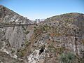
The Ojuela Bridge, built in 1892.

See also
 In Spanish: Mapimí para niños
