Mappsville, Virginia facts for kids
Quick facts for kids
Mappsville, Virginia
|
|
|---|---|

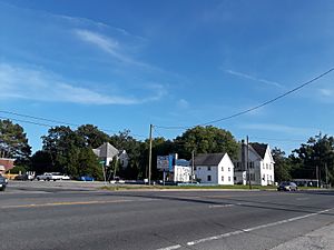
U.S. Route 13 in Mappsville, July 2018
|
|

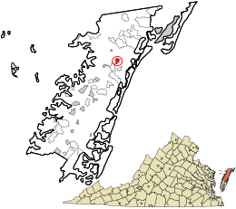
Location in Accomack County and the state of Virginia.
|
|
| Country | United States |
| State | Virginia |
| County | Accomack |
| Elevation | 46 ft (14 m) |
| Population
(2020)
|
|
| • Total | 311 |
| Time zone | UTC−5 (Eastern (EST)) |
| • Summer (DST) | UTC−4 (EDT) |
| FIPS code | 51-48776 |
| GNIS feature ID | 2584875 |
Mappsville is a small community in Accomack County, Virginia, United States. It is called a census-designated place (CDP). This means it is an area that the United States Census Bureau defines for gathering population data. It is not an officially incorporated town or city.
According to the 2020 census, about 311 people live in Mappsville.
History and Landmarks
One important historical place in Mappsville is Wharton Place. This site was added to the National Register of Historic Places in 1974. The National Register lists places that are important to the history of the United States.
Geography
Mappsville is located in Virginia. It sits at an elevation of about 46 feet (14 meters) above sea level.
Population and People
The number of people living in Mappsville has changed over time.
- In 2010, the population was 440 people.
- By 2020, the population had decreased to 311 people.
Who Lives in Mappsville?
The people living in Mappsville come from different backgrounds. Here's a look at the main groups based on the 2020 census:
- About 37% of the people are Black or African American.
- Around 9% are White.
- A large group, about 52%, are of Hispanic or Latino background. This group can be of any race.
- A small number of people are of mixed races.
See also
 In Spanish: Mappsville (Virginia) para niños
 | Leon Lynch |
 | Milton P. Webster |
 | Ferdinand Smith |

