Accomack County, Virginia facts for kids
Quick facts for kids
Accomack County
|
||
|---|---|---|

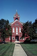
Accomack County Courthouse
|
||
|
||

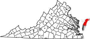
Location within the U.S. state of Virginia
|
||
 Virginia's location within the U.S. |
||
| Country | ||
| State | ||
| Founded | 1671 | |
| Seat | Accomac | |
| Largest town | Chincoteague | |
| Area | ||
| • Total | 1,310 sq mi (3,400 km2) | |
| • Land | 450 sq mi (1,200 km2) | |
| • Water | 861 sq mi (2,230 km2) 65.7% | |
| Population
(2020)
|
||
| • Total | 33,413 | |
| • Density | 25.51/sq mi (9.85/km2) | |
| Time zone | UTC−5 (Eastern) | |
| • Summer (DST) | UTC−4 (EDT) | |
| Congressional district | 2nd | |
Accomack County is a county in the United States. It is located in the state of Virginia. Together with Northampton County, it forms the Eastern Shore region. This area is part of the Delmarva Peninsula. The Chesapeake Bay is to the west, and the Atlantic Ocean is to the east.
The town of Accomac is the county seat. This means it is where the county government is located. Chincoteague is the largest town in Accomack County.
The county was named after the Accawmack Indians. They lived in the area when English explorers first arrived in 1603. The region was first called "Accomac Shire". It was later renamed Northampton County in 1642. The current Accomack County was created from Northampton County in 1663.
In 2020, about 33,413 people lived in Accomack County. The number of people living here has stayed about the same for many years. Accomack is one of the poorer areas in Virginia.
Contents
History of Accomack County
The county gets its name from the Accomac people. They were a Native American tribe who spoke a language called Eastern Algonquian. They lived in this area for a long time.
English explorers landed here in 1603. This was four years before the Jamestown Colony was started. Captain John Smith visited the region in 1608. At that time, about 6,000 Accomac people lived there. Their leader was Debedeavon, a powerful chief. The English colonists called him the "Laughing King." He was a strong friend to the colonists. He gave them large areas of land to use.
Accomac Shire was one of the first eight shires (like counties) in Virginia. It was created in 1634. The name "Accawmacke" means "on the other side" in the native language. In 1642, the colonists changed the name to Northampton. Then, in 1663, Northampton was split into two counties. The northern part got its original name back, becoming Accomack. The southern part stayed Northampton.
In 1670, the governor of the Virginia Colony, William Berkeley, removed Accomac County. But the Virginia General Assembly (the state's law-making group) brought it back in 1671.
In 1940, the General Assembly officially added a "k" to the end of the county's name. This is how it got its current spelling. The name "Accomack County" was first written down officially in 1943.
Geography of Accomack County
Accomack County is a large area. It covers about 1,310 square miles in total. About 450 square miles of this is land. The rest, about 861 square miles, is water. This means that 65.7% of the county is water. It is the largest county in Virginia by its total area.
The state of Delaware is not far away. It is about 36 miles from the Virginia and Maryland state line in Greenbackville.
Population and People
| Historical population | |||
|---|---|---|---|
| Census | Pop. | %± | |
| 1790 | 13,959 | — | |
| 1800 | 15,693 | 12.4% | |
| 1810 | 15,743 | 0.3% | |
| 1820 | 15,966 | 1.4% | |
| 1830 | 16,656 | 4.3% | |
| 1840 | 17,096 | 2.6% | |
| 1850 | 17,890 | 4.6% | |
| 1860 | 18,586 | 3.9% | |
| 1870 | 20,409 | 9.8% | |
| 1880 | 24,408 | 19.6% | |
| 1890 | 27,277 | 11.8% | |
| 1900 | 32,570 | 19.4% | |
| 1910 | 36,650 | 12.5% | |
| 1920 | 34,795 | −5.1% | |
| 1930 | 35,854 | 3.0% | |
| 1940 | 33,030 | −7.9% | |
| 1950 | 33,832 | 2.4% | |
| 1960 | 30,635 | −9.4% | |
| 1970 | 29,004 | −5.3% | |
| 1980 | 31,268 | 7.8% | |
| 1990 | 31,703 | 1.4% | |
| 2000 | 38,305 | 20.8% | |
| 2010 | 33,164 | −13.4% | |
| 2020 | 33,413 | 0.8% | |
| U.S. Decennial Census 1790-1960 1900-1990 1990-2000 2010 2020 |
|||
In 2020, the total population of Accomack County was 33,413 people. The population density was about 84 people per square mile.
Most people in the county are White (about 59.3%). About 25.9% are Black or African American. About 10.3% of the population is Hispanic or Latino. People of mixed races make up about 3.3% of the population.
In 2022, the average income for a household in the county was $50,601. The average income per person was $29,202. Accomack and nearby Northampton County are the two poorest counties in Virginia.
Economy of Accomack County
Accomack County is known for its large chicken processing plants. These plants are owned by companies like Perdue Farms and Tyson Foods.
Transportation in Accomack County
Airport
- Accomack County Airport is located near the town of Melfa.
Major Highways
Several main roads run through Accomack County:
 US 13
US 13
 US 13 Bus.
 SR 175
 SR 176
 SR 178
 SR 179
 SR 180
 SR 182
 SR 187
 SR 316
Public Transportation
STAR Transit provides bus services for people in Accomack and Northampton counties. Its main office is in Tasley.
Education in Accomack County
The schools in the county are managed by Accomack County Public Schools. This is the only school district in the county.
High schools and K-12 schools include:
- Arcadia High School
- Chincoteague High School
- Nandua High School
- Tangier Combined School
Eastern Shore Community College is also located near Melfa.
Communities in Accomack County
Towns
Census Designated Places
These are areas that are not officially towns but are recognized for census purposes.
- Atlantic
- Bayside
- Bobtown
- Boston
- Captains Cove
- Cats Bridge
- Chase Crossing
- Deep Creek
- Gargatha
- Greenbackville
- Greenbush
- Harborton
- Horntown
- Lee Mont
- Makemie Park
- Mappsburg
- Mappsville
- Metompkin
- Modest Town
- Nelsonia
- New Church
- Oak Hall
- Pastoria
- Pungoteague
- Quinby
- Sanford
- Savage Town
- Savageville
- Schooner Bay
- Southside Chesconessex
- Tasley
- Temperanceville
- Wattsville
- Whitesville
Notable People from Accomack County
Many interesting people have come from Accomack County:
- William Anderson (1762–1829) – Born here, he became a United States Congressman for Pennsylvania.
- Thomas Evans (c.1755–1815) – Also born in Accomack County, he was a United States Congressman for Virginia.
- Lucy Virginia French (1825–1881) – A well-known writer.
- George T. Garrison (1835–1889) – Born in Accomack County, he served in the Virginia state legislature and as a United States Congressman.
- James Hamilton (c.1710–1783) – Born here, he became a lawyer and mayor of Philadelphia.
- James Henry (1731–1804) – Born in Accomack County, he was a lawyer and a delegate to the Continental Congress.
- Ralph Northam (born 1957) – Born and grew up in Accomack County, he became the 73rd Governor of Virginia.
- W. Sherman Savage (1890–1981) – Born and raised here, he was a historian who studied African Americans in the Old West.
- Henry A. Wise (1806–1876) – He was an ambassador, Governor of Virginia, and a Confederate General.
See also
 In Spanish: Condado de Accomack para niños
 | Frances Mary Albrier |
 | Whitney Young |
 | Muhammad Ali |


