Painter, Virginia facts for kids
Quick facts for kids
Painter Virginia
|
|
|---|---|

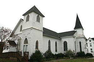
Painter-Garrisons United Methodist Church, founded in 1784.
|
|

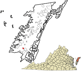
Location in Accomack County and the state of Virginia.
|
|
| Country | United States |
| State | Virginia |
| County | Accomack |
| Area | |
| • Total | 0.65 sq mi (1.69 km2) |
| • Land | 0.65 sq mi (1.69 km2) |
| • Water | 0.00 sq mi (0.00 km2) |
| Elevation | 36 ft (11 m) |
| Population
(2010)
|
|
| • Total | 229 |
| • Estimate
(2019)
|
224 |
| • Density | 344.09/sq mi (132.90/km2) |
| Time zone | UTC−5 (Eastern (EST)) |
| • Summer (DST) | UTC−4 (EDT) |
| ZIP code |
23420
|
| Area code(s) | 757, 948 |
| FIPS code | 51-60296 |
| GNIS feature ID | 1472020 |
Painter is a small town in Accomack County, Virginia, United States. In 2010, about 229 people lived there. It's a quiet place with a rich history.
Contents
History of Painter, Virginia
For a long time, most towns on the Eastern Shore of Virginia were built near the coast. This was because boats were the main way to move crops and animals.
How Painter Grew with the Railroad
In the 1880s, the New York, Pennsylvania, and Norfolk Railroad was built. This changed everything! People and businesses started moving away from the coast. They moved to the center of the shore. This is how new towns like Painter started to grow.
The Story of Painter-Garrisons United Methodist Church
The Painter-Garrisons United Methodist Church has a long history. It began in 1784 in a nearby place called Mappsburg. A church leader named Bishop Francis Asbury visited Jonathan Garrison's home many times.
By 1787, the church members built a chapel. This was the very first church building for Methodists on the Eastern Shore. The church building you see today was built in 1855.
Later, in 1906, a second church building was put up in Painter. This happened as more people moved to Painter. Twenty years later, the older 1855 church was moved to Painter. It was joined to the newer building. That's when it became known as Painter-Garrisons Church. The 1855 building is now the second-oldest Methodist church building on the Eastern Shore.
Historic Places in Painter
Two important places in Painter are listed on the National Register of Historic Places. They are Willowdale and Central High School. This means they are special places that are kept safe because of their history.
Geography of Painter
Painter is located at coordinates 37°35′8″N 75°47′0″W / 37.58556°N 75.78333°W. It is a small town.
Size and Elevation
The town covers about 0.6 square miles (1.6 square kilometers). All of this area is land. Painter sits at an elevation of 36 feet (about 11 meters) above sea level.
Population of Painter
| Historical population | |||
|---|---|---|---|
| Census | Pop. | %± | |
| 1960 | 349 | — | |
| 1970 | 363 | 4.0% | |
| 1980 | 321 | −11.6% | |
| 1990 | 259 | −19.3% | |
| 2000 | 246 | −5.0% | |
| 2010 | 229 | −6.9% | |
| 2019 (est.) | 224 | −2.2% | |
| U.S. Decennial Census | |||
In 2000, there were 246 people living in Painter. The population has changed over the years. In 2010, it was 229 people. By 2019, it was estimated to be around 224 people.
Age Groups in Painter
In 2000, about 22.8% of the people were under 18 years old. About 25.2% were 65 years old or older. The average age in Painter was 41 years.
Climate in Painter
Painter has a climate with hot, humid summers. The winters are usually mild to cool. This type of weather is called a humid subtropical climate. It means the area gets a good amount of rain all year.
Transportation in Painter
Getting around Painter and to other places is possible in a few ways.
Main Roads
Two main roads go through or near Painter:
 US 13
US 13 SR 182
Public Transport
STAR Transit offers public transportation. It connects Painter to other towns. These include Cape Charles and Onley. This service helps people travel around Accomack and Northampton counties.
Railroads
The Bay Coast Railroad used to provide freight train service to Painter. This means it moved goods by train. However, the railroad stopped operating in 2018.
See also
 In Spanish: Painter (Virginia) para niños
 | Laphonza Butler |
 | Daisy Bates |
 | Elizabeth Piper Ensley |


