Parksley, Virginia facts for kids
Quick facts for kids
Parksley, Virginia
|
|
|---|---|

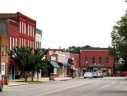
Dunne Avenue and Bennett Street, the commercial center of Parksley
|
|

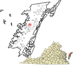
Location in Accomack County and the state of Virginia.
|
|
| Country | United States |
| State | Virginia |
| County | Accomack |
| Area | |
| • Total | 0.62 sq mi (1.60 km2) |
| • Land | 0.62 sq mi (1.60 km2) |
| • Water | 0.00 sq mi (0.00 km2) |
| Elevation | 43 ft (13 m) |
| Population
(2010)
|
|
| • Total | 842 |
| • Estimate
(2019)
|
808 |
| • Density | 1,311.69/sq mi (506.15/km2) |
| Time zone | UTC−5 (Eastern (EST)) |
| • Summer (DST) | UTC−4 (EDT) |
| ZIP code |
23421
|
| Area code | 757, 948 |
| FIPS code | 51-60680 |
| GNIS feature ID | 1497072 |
Parksley is a small town located in Accomack County, Virginia, in the United States. According to the 2010 census, about 842 people live there. Parksley is also home to the Eastern Shore Railway Museum, which is a fun place to learn about trains.
Contents
Where is Parksley Located?
Parksley is found at these coordinates: 37°47′6″N 75°39′15″W / 37.78500°N 75.65417°W. It is a small town, covering about 0.6 square miles (1.6 square kilometers) of land. The town sits at an elevation of 43 feet above sea level.
How Many People Live in Parksley?
| Historical population | |||
|---|---|---|---|
| Census | Pop. | %± | |
| 1920 | 601 | — | |
| 1930 | 697 | 16.0% | |
| 1940 | 701 | 0.6% | |
| 1950 | 883 | 26.0% | |
| 1960 | 850 | −3.7% | |
| 1970 | 903 | 6.2% | |
| 1980 | 979 | 8.4% | |
| 1990 | 779 | −20.4% | |
| 2000 | 837 | 7.4% | |
| 2010 | 842 | 0.6% | |
| 2019 (est.) | 808 | −4.0% | |
| U.S. Decennial Census | |||
In 2000, there were 837 people living in Parksley. These people lived in 363 households. About 27% of these households had children under 18. The average household had 2.31 people.
The median age in Parksley was 41 years old. This means half the people were younger than 41, and half were older. About 23% of the population was under 18 years old.
A Look at Parksley's History
Parksley's story began with the arrival of the New York, Philadelphia and Norfolk Railroad in the mid-1880s. This railroad connected the lower Delmarva Peninsula to markets in the northeast. Many new towns, including Parksley, were created along its path.
Parksley was designed in 1885 by the Parksley Land Improvement Company. It was the second planned town in Virginia along this new railroad line. The town officially became incorporated in 1904.
In the early 1900s, Parksley became a key place for shipping. Farmers and fishermen used the railroad to send their products to other areas. This included seafood from the Chesapeake Bay and Atlantic Ocean, as well as farm goods.
During World War II, Parksley played a role in protecting the East Coast. It was home to the Shore National Guard Armory. Its airfield was used by the Civil Air Patrol. They helped watch for possible German attacks. Parksley also had a baseball team called the Parksley Spuds. They played in the Eastern Shore Baseball League.
Most of Parksley's historic train tracks were removed around 2021. This decision was made by Canonie Atlantic Co. Some local people and the New York, Philadelphia and Norfolk Railroad protested this. However, the removal was approved. The only train tracks left in Parksley are those connected to the Eastern Shore Railway Museum.
What is Parksley's Economy Like?
The main industry in Parksley is agriculture. This means farming is very important to the town's economy. Two large companies, Perdue Farms and Tyson Foods, have big chicken processing factories in Parksley.
How to Get Around Parksley
Main Roads
 SR 176
Public Transport
STAR Transit offers public transportation. This service connects Parksley to nearby towns. These include Onley and Oak Hall. It also links to other communities in Accomack and Northampton counties.
See also
 In Spanish: Parksley (Virginia) para niños
 | Stephanie Wilson |
 | Charles Bolden |
 | Ronald McNair |
 | Frederick D. Gregory |


