Accomac, Virginia facts for kids
Quick facts for kids
Accomac, Virginia
|
||
|---|---|---|
|
Town
|
||

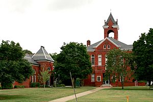
The historic court green in Accomac
|
||
|
||

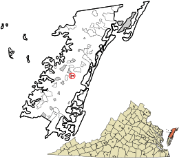
Location in Accomack County and the state of Virginia.
|
||
| Country | United States | |
| State | Virginia | |
| County | Accomack | |
| Area | ||
| • Total | 0.41 sq mi (1.06 km2) | |
| • Land | 0.41 sq mi (1.06 km2) | |
| • Water | 0.00 sq mi (0.00 km2) | |
| Elevation | 39 ft (12 m) | |
| Population
(2020)
|
||
| • Total | 526 | |
| • Estimate
(2021)
|
522 | |
| • Density | 1,188.73/sq mi (458.69/km2) | |
| Time zone | UTC−5 (Eastern (EST)) | |
| • Summer (DST) | UTC−4 (EDT) | |
| ZIP code |
23301
|
|
| Area codes | 757, 948 | |
| FIPS code | 51-00180 | |
| GNIS feature ID | 1498445 | |
Accomac is a small town in Virginia, United States. It is the main town, or county seat, of Accomack County. In 2020, about 526 people lived there.
Contents
History of Accomac
Accomac County was one of the first eight areas, called shires, in Virginia. It was set up in 1634. At first, the government was in the southern part of the Eastern Shore of Virginia. This changed when the shore was split into two counties in 1663.
Early Settlement and Religion
During this time, different religions started to grow in the area. A Presbyterian minister named Francis Makemie had a farm nearby. He used it as a base for his travels and religious work. Another early religious leader, Elijah Baker, a Baptist, also came to the Accomac area before the American Revolutionary War.
Becoming a Town
After Accomack County was formed, the court met in different places. In the 1690s, it moved to a house at the spot that later became Accomac. This place was then known as Matompkin. A brick courthouse was built in 1756. The area around it became known as Accomack Courthouse.
On December 7, 1786, several people asked the Virginia House of Delegates to make Accomack Courthouse an official town. Their request was approved. The town was named "Drummond" after Richard Drummond, who owned a lot of land there. Many old houses and churches in the town were built between the late 1700s and early 1800s. These buildings show styles like Georgian, Federal, and Greek Revival architecture. The town grew because it was a stop for a ferry that crossed Chesapeake Bay. Today, a modern ferry travels between nearby Onancock, Virginia and Tangier Island.
The Civil War and Beyond
During the American Civil War, the Union Army took control of the Eastern Shore. They wanted to stop supplies from reaching the South. They also wanted to prevent the Confederate Army from attacking the North through Maryland. Union General Henry H. Lockwood led these forces. He set up his headquarters in the rectory of St. James Episcopal Church. The town of Drummondtown was lucky. It did not suffer much damage during the war. Only the Presbyterian and Methodist Churches were used by the army for stables and housing.
In the late 1800s, Drummondtown slowly became more successful. This was helped by the arrival of the railroad from the north. Many new homes were built around the town in the 1880s and 1890s. The railroad also caused a challenge for Drummondtown. People in the new town of Parksley wanted to move the county seat there. After almost ten years of debate, a vote was held in 1895. The people of Accomack County decided to keep the court in Drummondtown. By this time, the town's name had been changed to "Accomac." This change was made by the United States Post Office Department on August 9, 1893. The name Accomac comes from a Native American word meaning "on the other side."
General Information
- ZIP Code: 23301
- Area Code: 757
- Local Phone Exchange: 787
- School District: Accomack County Public Schools
Geography
Accomac is located at 37°43′7″N 75°40′2″W / 37.71861°N 75.66722°W. The town covers about 0.4 square miles (1.1 square kilometers) of land. There is no water area within the town limits.
Demographics
| Historical population | |||
|---|---|---|---|
| Census | Pop. | %± | |
| 1950 | 500 | — | |
| 1960 | 414 | −17.2% | |
| 1970 | 373 | −9.9% | |
| 1980 | 522 | 39.9% | |
| 1990 | 466 | −10.7% | |
| 2000 | 547 | 17.4% | |
| 2010 | 519 | −5.1% | |
| 2020 | 526 | 1.3% | |
| 2021 (est.) | 522 | 0.6% | |
| U.S. Decennial Census | |||
In 2000, there were 547 people living in Accomac. The town had 199 households and 125 families. The population density was about 1,322 people per square mile. Most residents were White (71.12%) or African American (24.68%). A smaller number of people were Asian or from other backgrounds. About 2.19% of the population was Hispanic or Latino.
The average household had about 2.13 people. The average family had about 2.71 people. The median age in the town was 40 years old. This means half the people were older than 40 and half were younger.
Transportation
Major Highways
 US 13
US 13
 US 13 Bus.
Public Transportation
STAR Transit offers public bus services. These services connect Accomac with nearby towns like Onley and Oak Hall. They also link to other communities in Accomack and Northampton counties.
Notable People
- Thomas H. B. Browne: Born in Drummondtown, he became a United States Congressman.
- Millie Tunnell: Born in Drummondtown, she was an emancipated slave. She met George Washington and lived to be 111 years old.
- Henry A. Wise: Born in Drummondtown, he later became the Governor of Virginia.
See also
 In Spanish: Accomac para niños
 | Jackie Robinson |
 | Jack Johnson |
 | Althea Gibson |
 | Arthur Ashe |
 | Muhammad Ali |


