Mercedes District, Montes de Oca facts for kids
Quick facts for kids
Mercedes
|
|
|---|---|
|
District
|
|

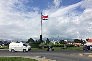
La Bandera roundabout in 2016, on Route 39 in this district.
|
|
| Country | |
| Province | San José |
| Canton | Montes de Oca |
| Area | |
| • Total | 1.44 km2 (0.56 sq mi) |
| Elevation | 1,200 m (3,900 ft) |
| Population
(2011)
|
|
| • Total | 4,688 |
| • Density | 3,256/km2 (8,432/sq mi) |
| Time zone | UTC−06:00 |
| Postal code |
11503
|
Mercedes is a special area called a district. It is located in the Montes de Oca canton. This canton is part of the San José province in Costa Rica.
Contents
Exploring Mercedes's Geography
Mercedes is a small district. It covers an area of about 1.44 square kilometers. The district is also quite high up. Its elevation is about 1200 meters above sea level.
Neighborhoods in Mercedes
Mercedes is made up of several smaller areas. These are called barrios, which means neighborhoods. Here are some of them:
- Betania
- Alma Máter
- Damiana
- Dent (part of it)
- Guaymí
- Paso Hondo
- Paulina
- Profesores
Understanding Mercedes's Population
In 2011, a special count was done. This count is called a census. The 2011 census showed that Mercedes had 4,688 people living there.
Roads and Transportation
Getting around Mercedes is easy by road. The district has access to important road routes. These routes help people travel to and from Mercedes.
Main Road Routes
Here are the main road routes that go through Mercedes:
See also
 In Spanish: Mercedes (Montes de Oca) para niños
 | Sharif Bey |
 | Hale Woodruff |
 | Richmond Barthé |
 | Purvis Young |


