
San José Province facts for kids
Quick facts for kids
Province of San José
Provincia de San José
|
|||
|---|---|---|---|
.jpg)
National theatre, San José
|
|||
|
|||

Location of the Province of San José
|
|||
| Country | Costa Rica | ||
| Capital city | San José | ||
| Area | |||
| • Total | 4,965.90 km2 (1,917.34 sq mi) | ||
| Population
(2011)
|
|||
| • Total | 1,404,242 | ||
| • Density | 282.7769/km2 (732.3889/sq mi) | ||
| Demonym(s) | Josefino | ||
| ISO 3166 code | CR-SJ | ||


San José is an important province in Costa Rica. It is located right in the middle of the country. The main city, and also the capital of Costa Rica since 1823, is San José.
Contents
Where is San José Province Located?
The San José province shares its borders with several other provinces. To the north, it touches Alajuela and Heredia. To the east, you'll find Cartago and Limón. Finally, to the south and west, it borders the Puntarenas province.
 |
Alajuela | Heredia | |
|
| Puntarenas | Cartago | |||
| Puntarenas | Limón |
Exploring San José's Geography
San José province is located in the central part of Costa Rica. It covers an area of about 4,965.90 km2 (1,917.34 sq mi). That's almost 5,000 square kilometers!
Mountains and Rivers in San José
You'll find many impressive mountains here. Some of the main ones include Turrubares, Camora, Cangreja, Nara, Cerro de la Muerte, San Jerónimo, and Las Vueltas.
Several rivers also flow through the province. These include the Grande de Candelaria, Pirrís, Virilla, Naranjo, División, Chirripó, General, and Pejibaye rivers.
People of San José Province
People who live in the San José province are called josefinos. If you're talking about women, they are called josefinas.
In 2011, the San José province had a population of 1,404,242 people. This means there were about 282.8 inhabitants for every square kilometer. The city of San José itself is the most populated area, with 288,054 residents.
How San José Province is Organized
The San José province is divided into 20 smaller areas called cantons. Each of these cantons is then split into even smaller parts called Districts. There are 124 districts in total across the province.
| No. | Canton | Capital City | Number of Districts | Population (2011) |
Area (km²) |
People per km² |
|---|---|---|---|---|---|---|
| 1 | San José | San José | 11 | 288,054 | 44.62 | 6,455.7 |
| 2 | Escazú | Escazú | 3 | 56,509 | 34.49 | 1,638.4 |
| 3 | Desamparados | Desamparados | 13 | 208,411 | 118.26 | 1,762.3 |
| 4 | Puriscal | Puriscal | 10 | 33,004 | 553.66 | 59.6 |
| 5 | Tarrazú | San Marcos | 3 | 16,280 | 297.5 | 54.7 |
| 6 | Aserrí | Aserrí | 7 | 57,892 | 167.10 | 346.5 |
| 7 | Mora | Ciudad Colón | 7 | 26,294 | 162.04 | 162.3 |
| 8 | Goicoechea | Guadalupe | 7 | 115,084 | 31.50 | 3,653.5 |
| 9 | Santa Ana | Santa Ana | 6 | 49,123 | 61.42 | 799.8 |
| 10 | Alajuelita | Alajuelita | 5 | 77,603 | 21.17 | 3,665.7 |
| 11 | Vásquez de Coronado | San Isidro | 5 | 60,486 | 222.20 | 272.2 |
| 12 | Acosta | San Ignacio | 5 | 20,209 | 342.24 | 59.0 |
| 13 | Tibás | San Juan | 5 | 64,842 | 8.15 | 7,956.1 |
| 14 | Moravia | San Vicente | 3 | 56,919 | 28.62 | 1,988.8 |
| 15 | Montes de Oca | San Vicente | 4 | 49,132 | 15.16 | 3,240.9 |
| 16 | Turrubares | San Pablo | 5 | 5,512 | 415.29 | 13.3 |
| 17 | Dota | Santa María | 3 | 6,948 | 400.22 | 17.4 |
| 18 | Curridabat | Curridabat | 4 | 65,206 | 15.95 | 4,088.2 |
| 19 | Pérez Zeledón | San Isidro de El General | 12 | 134,534 | 1,905.51 | 70.6 |
| 20 | León Cortés | San Pablo | 6 | 12,200 | 120.80 | 101.0 |
| Total for the Province | 124 | 1,404,242 | 4,965.90 | 282.8 | ||
Gallery
-
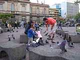
Plaza de la Cultura, a popular square in San José.
-
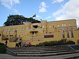
The National Museum of Costa Rica.
-
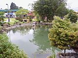
Okayama square, a peaceful park.


Images for kids
-
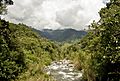
The Blanco River in Pérez Zeledón county. Many rivers in San José province are shallow and narrow, often running through mountains, making them hard to navigate.
-

Cerro de la Muerte, a mountain in the southeast of the province.


See also
 In Spanish: Provincia de San José para niños
