
Limón Province facts for kids
Quick facts for kids
Limón Province
Provincia de Limón
|
|||
|---|---|---|---|

Beach in Tortuguero National Park, Limón
|
|||
|
|||

Location of the Province of Limón
|
|||
| Country | Costa Rica | ||
| Province since | 1902 | ||
| Capital city | Puerto Limón | ||
| Area | |||
| • Total | 9,188.52 km2 (3,547.71 sq mi) | ||
| Population
(2011)
|
|||
| • Total | 386,862 | ||
| • Density | 42.10275/km2 (109.04563/sq mi) | ||
| Demonym(s) | Limonense | ||
| ISO 3166 code | CR-L | ||


Limón is a special part of Costa Rica, like a big state or region. It's on the eastern side of the country, right next to the beautiful Caribbean Sea. The main city and capital of Limón is called Puerto Limón.
Contents
Where is Limón Province Located?
Limón Province shares its borders with other parts of Costa Rica. To the west, it's next to Heredia, Cartago, and San José. To the southwest, you'll find Puntarenas. Looking north, Limón touches Nicaragua. To the south, it borders Panama. And to the east, it has a long coastline along the Caribbean Sea.
 |
Heredia | Nicaragua | |
|
| San José Cartago |
Caribbean Sea | |||
| Puntarenas | Panama |
Exploring Limón's Geography
Limón is the fourth largest province in Costa Rica. It covers an area of about 9,188.52 km2 (3,547.71 sq mi). This means it makes up about 18% of Costa Rica's total land.
Most of Limón is flat land close to sea level. But in the southwest, you'll find the Cordillera de Talamanca. This is a mountain range that includes the highest mountain in Costa Rica, Cerro Chirripó. It stands tall at 3,819 m (12,530 ft) above sea level.
The main river in Limón is the Reventazón. It's the second longest river in the country, stretching about 145 m (476 ft) long.
Understanding Limón's Weather
Limón has a unique climate compared to the rest of Costa Rica. It rains throughout the year here. The months with the least rain are usually September and October. The climate in Puerto Limón is known as a "Tropical Rainforest Climate." This means it's warm and wet all the time.
On average, Puerto Limón gets about 3,398.5 mm (133.8 in) of rain each year. July is usually the wettest month, with about 411.5 mm (16.2 in) of rain. September is the driest, with around 142.2 mm (5.6 in).
The average temperature in Puerto Limón is 26.1 °C (79.0 °F). May is typically the warmest month, averaging 27.2 °C (81.0 °F). January is the coolest, with an average temperature of 25 °C (77 °F).
| Climate data for Puerto Limón, France | |||||||||||||
|---|---|---|---|---|---|---|---|---|---|---|---|---|---|
| Month | Jan | Feb | Mar | Apr | May | Jun | Jul | Aug | Sep | Oct | Nov | Dec | Year |
| Mean daily maximum °C (°F) | 28 (82) |
28 (82) |
28 (82) |
29 (84) |
29 (84) |
29 (84) |
28 (82) |
28 (82) |
30 (86) |
29 (84) |
28 (82) |
28 (82) |
29 (83) |
| Daily mean °C (°F) | 25 (77) |
25 (77) |
26 (79) |
26 (79) |
27 (81) |
26 (79) |
26 (79) |
26 (79) |
26 (79) |
26 (79) |
26 (79) |
25 (77) |
26 (79) |
| Mean daily minimum °C (°F) | 22 (72) |
22 (72) |
22 (72) |
23 (73) |
23 (73) |
23 (73) |
23 (73) |
23 (73) |
23 (73) |
23 (73) |
23 (73) |
22 (72) |
23 (73) |
| Average rainfall mm (inches) | 310 (12.2) |
210 (8.3) |
200 (7.9) |
270 (10.6) |
280 (11.0) |
280 (11.0) |
410 (16.1) |
290 (11.4) |
140 (5.5) |
180 (7.1) |
370 (14.6) |
400 (15.7) |
3,340 (131.4) |
| Source: Weatherbase.com [1] | |||||||||||||
People of Limón Province
People who live in Limón Province are called Limonenses. This name is used for both boys and girls.
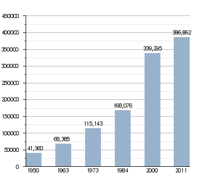
In 2011, about 386,862 people lived in Limón. This was about 9% of all the people in Costa Rica. The province has about 42.1 people for every square kilometer. The area called Pococí has the most people, with 125,962 residents.
How Limón's Population Has Grown
How Limón Province is Organized
Limón Province is divided into 6 main areas called cantons. These cantons are then split into 29 smaller areas called Districts.
| No. | Canton | Capital | Districts | Population (2011) |
Area (km²) |
Density (Inh./km²) |
|---|---|---|---|---|---|---|
| 1 | Limón | Puerto Limón | 4 | 94,415 | 1,765.79 | 53.5 |
| 2 | Pococí | Guápiles | 7 | 125,962 | 2,403.49 | 52.4 |
| 3 | Siquirres | Siquirres | 6 | 56,786 | 860.19 | 66.0 |
| 4 | Talamanca | Bribri | 4 | 30,712 | 2,809.93 | 10.9 |
| 5 | Matina | Matina | 3 | 37,721 | 772.64 | 48.8 |
| 6 | Guácimo | Guácimo | 5 | 41,266 | 576.48 | 71.6 |
Limón's Economy and Jobs
The main way people in Limón make a living is through farming. They grow many different crops like bananas, pineapples, cacao (which is used to make chocolate), and pejibaye. These are all tropical plants that grow well in the warm, wet climate.
Limón is also home to the important port of Moín. This port is very busy and is the most important one in all of Costa Rica for shipping goods.
Gallery
-
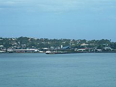
Puerto Limón
-
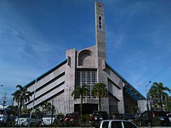
The Cathedral of Limón
-
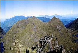
The Cerro Chirripó mountain


Images for kids
-
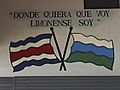
Translation: "Wherever I go, Limónense I am"
-

Demonstration against CAFTA-DR in Bribrí town
-

Caribbean coast in Limón


See also
 In Spanish: Provincia de Limón para niños
