
Cartago Province facts for kids
Quick facts for kids
Province of Cartago
Provincia de Cartago
|
|||
|---|---|---|---|
|
|||

Location of the Province of Cartago
|
|||
| Country | Costa Rica | ||
| Capital city | Cartago | ||
| Area | |||
| • Total | 3,124.67 km2 (1,206.44 sq mi) | ||
| Population
(2011)
|
|||
| • Total | 490,903 | ||
| • Density | 157.1056/km2 (406.9015/sq mi) | ||
| Demonym(s) | Cartaginés | ||
| ISO 3166 code | CR-C | ||


Cartago is a province in Costa Rica. It is located in the central part of the country. The main city and capital of the province is also called Cartago.
Contents
Where is Cartago Province?
The Cartago province is a landlocked area. This means it does not touch the ocean. It shares borders with the Limón province to the east and north. To the south and west, it borders the San José province.
 |
Limón | |
||
| San José | Limón | |||
| San José |
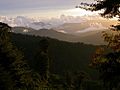
Geography and Nature
Cartago is the second smallest province in Costa Rica. Only the Heredia province is smaller. It covers an area of about 3,124.67 km2 (1,206.44 sq mi).
Mountains and Volcanoes
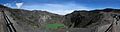
There are two main mountain ranges in the province. One is the Cordillera Central. It is also known as the Volcanic Central mountain range. The other is the Talamanca mountain range.
You can find several volcanoes in Cartago province. The Irazú is one of them, standing 3,432 m (11,260 ft) tall. Another is the Turrialba, which is 3,340 m (10,960 ft) high.
Rivers of Cartago
Many rivers flow through the province. Some important ones include the Reventado, Reventazón, and Grande de Orosi rivers. Other rivers are the Macho, Tiribí, and Pejibaye.
People of Cartago
People who live in Cartago province are called cartaginés. If it's a woman, she is called cartaginesa.
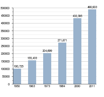
In 2011, the Cartago province had a population of 490,903 people. This means there were about 157.1 people per square kilometer. The city of Cartago itself had the most residents, with 147,898 people.
How Cartago's Population Has Grown
How Cartago is Divided
The Cartago province is split into 8 smaller areas called cantons. These cantons are then divided into 47 Districts.

| No. | Canton | Capital | Districts | Population (2011) |
Area (km²) |
Density (Inh./km²) |
|---|---|---|---|---|---|---|
| 1 | Cartago | Cartago | 11 | 151,774 | 287.77 | 527.4 |
| 2 | Paraíso | Paraíso | 5 | 58,030 | 411.91 | 43.5 |
| 3 | La Unión | Tres Ríos | 8 | 101,195 | 44.83 | 2,257.3 |
| 4 | Jiménez | Juan Viñas | 3 | 15,716 | 286.43 | 54.9 |
| 5 | Turrialba | Turrialba | 12 | 72,631 | 1,642.67 | 44.2 |
| 6 | Alvarado | Pacayas | 3 | 14,302 | 81.06 | 176.4 |
| 7 | Oreamuno | San Rafael | 5 | 46,136 | 202.31 | 228.0 |
| 8 | El Guarco | Tejar | 4 | 42,474 | 167.69 | 253.3 |
What Cartago Produces
Farming is a very important part of the economy in Cartago. Farmers grow many different crops. These include potatoes, coffee, and sugarcane. They also grow Macadamia nuts, pejibaye (a type of palm fruit), and ornamental plants (plants grown for their beauty).
Cartago is also a place where many manufacturing companies have set up factories. These companies often make products to export to other countries. The province has the largest industrial zone in Costa Rica.
To help produce electricity, there are eight dams in the province. These dams use water to create hydroelectricity.
Gallery
-
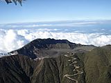
Turrialba volcano
-
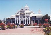
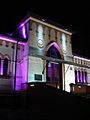
Virgen de los Ángeles basilica, Cartago
-
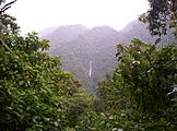
Tapantí National Park
-
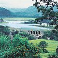
Angostura dam, Turrialba


Images for kids
-

Colegio San Luis Gonzaga
-
Museo Municipal de Cartago
-
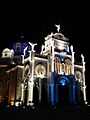
Basílica de Los Ángeles
-
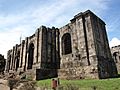
View of the ruins of the Parroquia de Santiago Apóstol in Cartago, Costa Rica.
-
Irazú volcano
-
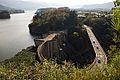
Cachi Dam
-
Cerro de la Muerte
-
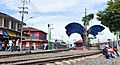
Cartago INCOFER Train Station


See also
 In Spanish: Provincia de Cartago para niños
