Moravia (canton) facts for kids
Quick facts for kids
Moravia
|
|||
|---|---|---|---|
|
|||
| Country | |||
| Province | San José | ||
| Creation | 1 August 1914 | ||
| Named for | Juan Rafael Mora Porras | ||
| Head city | San Vicente | ||
| Districts |
Districts
|
||
| Government | |||
| • Type | Municipality | ||
| • Body | Municipalidad de Moravia | ||
| Area | |||
| • Total | 28.62 km2 (11.05 sq mi) | ||
| Elevation | 1,297 m (4,255 ft) | ||
| Population
(2011)
|
|||
| • Total | 56,919 | ||
| • Density | 1,988.8/km2 (5,150.9/sq mi) | ||
| Time zone | UTC−06:00 | ||
| Canton code | 114 | ||
Moravia is a canton, or region, in the San José province of Costa Rica. It is the fourteenth canton created in this province. The main city and capital of the canton is San Vicente.
Contents
What's in a Name?
Moravia is named after Juan Rafael Mora Porras. He was a very important President of Costa Rica from 1849 to 1859.
There was already a canton called Mora. To avoid confusion, this new canton was given the name Moravia.
A Look at Moravia's History
Moravia became an official canton on August 1, 1914. This happened through a special rule called decree 55.
On the same day, Villa San Vicente was established as a town. The first meeting of Moravia's local government happened on January 19, 1915. In that same year, electric streetlights were installed, making the town brighter.
Later, on December 6, 1963, San Vicente became a city. This was made possible by Law No. 3248.
Exploring Moravia's Geography
Moravia covers an area of about 28.62 square kilometers (11 square miles). It sits at an average height of 1,297 meters (4,255 feet) above sea level.
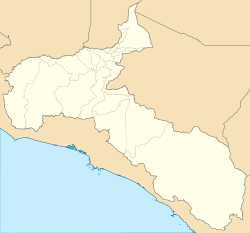
The canton stretches from the northern parts of San José, the country's capital. It then goes northeast towards the Central Mountain Range.
Several rivers help form Moravia's borders. These include the Virilla, Pará, and Blanco rivers in the north and west. The Quebrada Azul and Macho rivers are in the southeast. Other rivers flowing through Moravia are Quebrada Barreal, Acequia, and Hondura.
You can also find mountain peaks here. Some of the highest are Zurquí (1,583m), Vargas (1,396m), and Trina (1,270m).
Moravia has both busy city areas in the south and quiet mountain areas in the north. It is surrounded by other cantons like Vázquez de Coronado and Goicoechea.
Moravia's Districts
The canton of Moravia is divided into three main areas called districts:
People of Moravia
| Historical population | |||
|---|---|---|---|
| Census | Pop. | %± | |
| 1927 | 2,778 | — | |
| 1950 | 5,727 | 106.2% | |
| 1963 | 11,642 | 103.3% | |
| 1973 | 19,548 | 67.9% | |
| 1984 | 33,038 | 69.0% | |
| 2000 | 50,419 | 52.6% | |
| 2011 | 56,919 | 12.9% | |
|
Instituto Nacional de Estadística y Censos |
|||
According to the 2011 census, Moravia had a population of 56,919 people.
Schools and Learning
The first school in Moravia opened in 1848. It was called "school for the education of the children of the residents of San Vicente." This school was located near what is now Parque de Moravia.
In 1862, a special school was created to help those in need. It had separate sections for boys and girls.
A new school building was built in 1891 using adobe and brick. This school was later renamed Escuela Porfirio Brenes Castro in 1932. It is still an important school today.
Many other schools have been founded in Moravia. These include private schools like Saint Francis College (opened in 1950) and Saint Anthony School. There are also public high schools like Liceo de Moravia.
Moravia is also home to the Escuela Japonesa de San José. This is a Japanese international school for children living in Costa Rica.
Getting Around Moravia
Road Network
Several important roads pass through Moravia, connecting it to other parts of Costa Rica. These roads help people travel and transport goods.
See also
 In Spanish: Cantón de Moravia para niños
 | Delilah Pierce |
 | Gordon Parks |
 | Augusta Savage |
 | Charles Ethan Porter |


