Military Avenue (Omaha) facts for kids
Quick facts for kids |
|
|
Military Ave. Segment
|
|

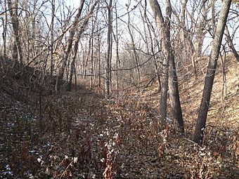
Remains of Military Road wagon track
|
|
| Location | Omaha, Nebraska |
|---|---|
| Built | 1858 |
| Architect | Capt. Edward Beckwith |
| NRHP reference No. | 93001400 |
| Added to NRHP | December 10, 1993 |
Military Avenue is a major road in Omaha, Nebraska. It's not just any road; a special part of it is listed on the National Register of Historic Places. This means it's an important historical site! Today, Military Avenue starts as Nebraska Highway 64 and goes all the way to Bennington Road, near North 204th Street.
Contents
History of Military Avenue
Why Was Military Avenue Built?
Military Avenue was originally part of the famous Overland Trail. This trail was a network of paths used by pioneers traveling west. In 1857, Captain Edward Beckwith of the United States Army planned out Military Avenue. His main goal was to create a road to move military supplies to Fort Kearny. Fort Kearny was an important army post in central Nebraska.
Who Used This Historic Road?
For about 50 years, thousands of travelers used Military Avenue. They were often pioneers heading to the Pacific Northwest to start new lives. The road was built on high ground on purpose. This gave travelers a clear view of the land around them. It helped protect them from unexpected attacks during their long journeys.
Military Avenue Today
Where Can You See the Original Road?
You can still see parts of the original wagon track today! It's near the Omaha Public Power District substation. This spot is close to North 90th and Fort Streets. It's a cool way to see a piece of history.
What Does "National Register of Historic Places" Mean?
A section of Military Avenue is listed on the National Register of Historic Places. This is a special list kept by the United States government. It includes places that are important in American history, architecture, archaeology, engineering, or culture. Being on this list helps protect the site and reminds everyone of its historical value.
 | Delilah Pierce |
 | Gordon Parks |
 | Augusta Savage |
 | Charles Ethan Porter |


