Mogotón facts for kids
Quick facts for kids Mogotón |
|
|---|---|
| Highest point | |
| Elevation | 2,085 m (6,841 ft) |
| Listing | Country high point |
| Geography | |
| Location | Nicaragua / Honduras |
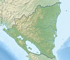
Mogotón is a tall mountain located in Central America. It sits right on the border between Nicaragua and Honduras. This mountain is part of the Dipilto and Jalapa Mountain Range Natural Reserve.
Mogotón is the highest point in Nicaragua. It reaches about 2,085 meters (6,841 feet) above sea level. This makes it a very important natural landmark for the country.
Contents
Where is Mogotón Located?
Mogotón is found in a special area called the Cordillera Dipilto y Jalapa Natural Reserve. This reserve helps protect the natural environment around the mountain. The mountain's peak marks the exact point where Nicaragua and Honduras meet.
The Border Region
The area around Mogotón is known for its natural beauty. It includes forests and different types of plants and animals. The border here is a natural one, following the mountain's path.
How Tall is Mogotón?
Mogotón stands at an impressive height of 2,085 meters. This is equal to 6,841 feet. Its height makes it the tallest mountain in Nicaragua. It is a significant geographic feature.
Measuring Mountain Heights
Scientists use special tools to measure how tall mountains are. They measure from sea level up to the very top of the peak. This helps us understand the highest points in different countries.
Why is Mogotón Important?
Mogotón is important because it is Nicaragua's highest point. It is a symbol of the country's geography. It also plays a role in the natural environment of the border region.
Natural Reserves
Natural reserves like the one Mogotón is in are important. They help protect wildlife and plants. They also keep natural areas safe for future generations to enjoy.
See also
- In Spanish: Mogotón para niños
 | Jackie Robinson |
 | Jack Johnson |
 | Althea Gibson |
 | Arthur Ashe |
 | Muhammad Ali |


