
Mount Somers / Te Kiekie facts for kids
Quick facts for kids Mount Somers |
|
|---|---|

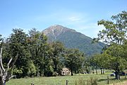
Mount Somers from Mount Winterslow
|
|
| Highest point | |
| Elevation | 1,688 m (5,538 ft) |
| Listing | List of mountains of New Zealand by height |
| Naming | |
| Native name | Te Kiekie (Māori) |
| Geography | |

Mount Somers
Location in New Zealand
|
|
| Parent range | Southern Alps |
| Climbing | |
| Easiest route | Mount Somers Summit Track |
Mount Somers / Te Kiekie is a mountain in the South Island of New Zealand. It is part of the lower hills of the Southern Alps. The mountain is about 1688 meters (5,538 feet) tall. You can easily see it from the Canterbury Plains. The area around Mount Somers is great for day trips and longer hikes.
Contents
What's in a Name?
The Māori Name: Te Kiekie
The mountain's Māori name is Te Kiekie. It is named after a chief who arrived long ago. This chief came on a special canoe called the Āraiteuru.
The European Name: Mount Somers
The name Mount Somers was given by Captain Joseph Thomas. He was a surveyor for the Canterbury Association in 1849. This name honors Thomas Somers-Cocks, a banker and politician. He was a member of the Canterbury Association.
The nearby village of Mount Somers was later named after the mountain. A railway line, the Mount Somers Branch, also got its name from the mountain. The village is about 10 kilometers (6 miles) south of the mountain's top.
Mountain's Make-Up: Rocks and Plants
How the Mountain Formed
Most hills in the Mid Canterbury area are made of a rock called greywacke. But Mount Somers / Te Kiekie is different. It was formed by a volcano! You can see cracks and lines in the rocks. These show how the volcano cooled down. There are also valuable rocks nearby. These include silica, sand, limestone, and coal.
Plants and Soil
The soil on Mount Somers is not very rich. It is hard for many plants to grow there. However, some areas are flat and get a lot of rain. This makes them perfect for plants that like wet, boggy places.
Hiking Adventures Around Mount Somers
Coal Mining History
People first found coal near Mount Somers in 1856. This led to the creation of the village of Mount Somers. A special track was built to carry the coal to the village. Coal mining stopped in 1954.
The Miners Track
The old coal track is now part of a hiking trail. It is called the Miners Track. This track goes from the Woolshed Creek car park to Woolshed Creek Hut. It is one of the most popular hikes in Mid Canterbury.
You can also reach Woolshed Creek Hut another way. This is the Rhyolite Ridge Track. It passes a large rock overhang called the Bus Stop.
The Mt Somers Track
Local people formed the Mt Somers Walkways Society in 1983. Their goal was to create a circular hiking path around the mountain. The Mt Somers Track officially opened in 1987. Later, a special shelter was added. This shelter is called Acland shelter. It is named after John Acland, who used to own the land.
You can reach the very top of Mount Somers / Te Kiekie. You start from either the Woolshed Creek car park or the Sharplin Falls car park. The Mt Somers Summit Track is a side path to the top. It can be very icy and hard to climb in winter.
Exploring the Mt Somers Track Loop
The Mt Somers Track starts and ends at the Sharplin Falls car park. The northern part of the path follows Bowyers Stream. Sharplin Falls used to be a popular spot. But it closed in 2015 because of falling rocks. The Department of Conservation later said it would stay closed forever.
After following Bowyers Stream, the track reaches Pinnacles Hut. This hut is named after the cool rock shapes behind it. The track then climbs over the Mount Somers saddle. It goes down to Woolshed Creek Hut. From there, it climbs up to the Bus Stop overhang.
The path continues past the Acland Shelter. It goes along the south side of Mount Somers / Te Kiekie. Then it climbs onto Staveley Hill. This is where the Mt Somers Summit Track begins. From Staveley Hill, the track goes back down to the Sharplin Falls car park.
- Tramping in the Mount Somers / Te Kiekie area
-
Mount Somers / Te Kiekie seen from Staveley
-
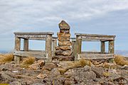
Summit of Mount Somers / Te Kiekie
-
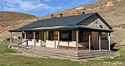
Woolshed Creek Hut
-
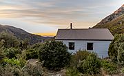
Pinnacles Hut
-
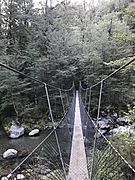
Halfway Bridge over Bowyers Stream
-

Mt Somers Track at the Bus Stop Overhang
-
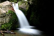
Sharplin Falls


