Muncho Lake facts for kids
Quick facts for kids Muncho Lake |
|
|---|---|
 |
|
| Location | British Columbia |
| Coordinates | 59°00′N 125°46′W / 59.000°N 125.767°W |
| Primary inflows | Trout River, Muncho Creek |
| Primary outflows | Trout River |
| Max. length | 12 kilometres (7.5 mi) |
| Max. width | 6 kilometres (3.7 mi) |
| Max. depth | 223 m (732 ft) |
| Surface elevation | 820 m (2,690 ft) |
| Settlements | Muncho Lake, British Columbia |
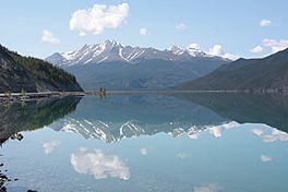
Muncho Lake is a beautiful lake located in northern British Columbia, Canada. It's famous for its stunning jade green color and is a popular spot for visitors traveling along the Alaska Highway.
Where is Muncho Lake?
Muncho Lake is found inside Muncho Lake Provincial Park. You can find it at kilometer 681 (or mile 423) along the famous Alaska Highway. The lake is about 12 kilometers (7.5 miles) long. Its width changes, but it can be as wide as 6 kilometers (3.7 miles). It's also very deep, reaching a maximum depth of 223 meters (732 feet)!
Mountains and Water
Tall mountains surround Muncho Lake. Some of these peaks, like those in the Terminal Range and Sentinel Range, reach over 2,000 meters (6,500 feet) high! The lake itself sits at an elevation of 820 meters (2,690 feet) above sea level. The lake is fed by the Trout River, which then flows into the larger Liard River.
Why is the Lake Green?
Muncho Lake has a special jade green color. This unique color comes from tiny bits of copper oxide. These tiny pieces wash into the lake from the rocks underneath. The name "Muncho" also has a special meaning. It comes from the Kaska language, where "muncho" means "big water."
Nearby Community
A small community called Muncho Lake is located on the southern shore of the lake. This is where the Trout River and Muncho Creek meet. There's also a special airport for seaplanes, called the Muncho Lake/Mile 462 Water Aerodrome, on the eastern side of the lake.
 | Percy Lavon Julian |
 | Katherine Johnson |
 | George Washington Carver |
 | Annie Easley |


