Murray County, Western Australia facts for kids
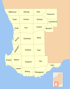
Murray County was one of the 26 special areas of land in Western Australia. These areas were set up in 1829 to help organize and manage land. They were called "cadastral divisions," which means they were like official maps used to keep track of who owned what land.
Murray County was named after Sir George Murray, who was a very important person in the British government. He was the Secretary of State for War and the Colonies from 1828 to 1830. This job meant he helped manage Britain's military and its colonies, like Western Australia. George Murray was also a personal friend of Lieutenant-Governor James Stirling, who was in charge of the new Swan River Colony (which became Western Australia).
What Was Murray County?
Murray County was one of the first ways the land in Western Australia was officially divided. Imagine drawing lines on a map to create different sections. These sections, or counties, helped the government keep records of land ownership. They were important for setting up new farms and towns as the colony grew.
Why Was It Important?
Even though Murray County isn't used in the same way today, its boundaries still matter. It roughly matches areas known as the Murray Land District and part of the Cockburn Sound Land District. These modern land districts are still used for official land records and ownership papers, often called "land titles." So, the old county lines still help us understand how land is divided and owned in that part of Western Australia.
 | Stephanie Wilson |
 | Charles Bolden |
 | Ronald McNair |
 | Frederick D. Gregory |


