
National Register of Historic Places listings in Ashe County, North Carolina facts for kids

Welcome to Ashe County, North Carolina! This page tells you about special places here that are listed on the National Register of Historic Places. This is like a national "honor roll" for buildings, sites, and objects that are important in American history, architecture, archaeology, engineering, or culture. When a place is added to this list, it means it's recognized for its unique value and is protected. It helps people learn about the past and keep these important spots safe for the future.
Contents
Historic Treasures in Ashe County
Ashe County has many amazing places that tell stories about the past. These include old buildings, churches, and even entire areas that have kept their historical feel. Let's explore some of them!
Important Buildings and Homes
Many buildings in Ashe County have been recognized for their history. They show us how people lived and worked long ago.
Ashe County Courthouse
The Ashe County Courthouse is a very important building in Jefferson. It was built in 1904 and has been the center of local government for over a hundred years. Imagine all the decisions made and stories shared within its walls! It's a great example of the architecture from that time.
Glendale Springs Inn
The Glendale Springs Inn in Glendale Springs is a beautiful old inn. It was built in 1895 and used to be a popular place for people to stay, especially those visiting the area for its fresh mountain air. It shows us what travel and hospitality were like over a century ago.
Worth's Chapel
Located in Creston, Worth's Chapel is a charming church built in 1902. It's a wonderful example of a small, traditional mountain church. Places like this often served as important community centers, not just for worship but also for social gatherings.
Historic Homes
Several old homes in Ashe County are also on the National Register. These include the Bower-Cox House, the Samuel Cox House, the John M. Pierce House, the Miller Homestead, and the John W. Tucker House. Each of these homes has its own unique story and shows us different styles of building from the past. They help us understand how families lived and grew in the region.
Community and Industrial Sites
Beyond homes, other types of buildings and areas are important because of their role in the community or local industries.
Elkland School Gymnasium
The Elkland School Gymnasium in Todd was built in 1938. School buildings are often important because they represent education and community life. This gymnasium was likely a place where many generations of students played, learned, and gathered for events.
Old Mills and Warehouses
Ashe County also has historic sites related to its past industries. The Clark-Miller Roller Mill near Lansing and the Cockerham Mill near Cockerham are examples of old mills. These mills were vital for grinding grain and processing other goods, showing us how local economies worked before modern factories. The R. T. Greer and Company Root and Herb Warehouse in Todd is another interesting site. It reminds us of a time when collecting and selling natural roots and herbs was an important business in the mountains.
Historic Districts and Archeological Sites
Sometimes, it's not just one building but a whole area or even an ancient site that is historically important.
Historic Districts
A "historic district" is a group of buildings, structures, or sites that are all important together because of their history or architecture. Ashe County has several of these:
- The Grassy Creek Historic District in Grassy Creek.
- The Lansing Historic District in Lansing.
- The Todd Historic District in Todd.
- The West Jefferson Historic District in West Jefferson.
These districts let us see how towns and communities developed over time, preserving the look and feel of past eras.
Archeological Sites
Some places are important because of what lies beneath the ground! The Shubal V. Alexander Archeological District and the Poe Fish Weir are examples of archeological sites. Archeologists study these sites to learn about ancient cultures and how people lived thousands of years ago. A "fish weir" is an old structure, often made of rocks, used to catch fish in a river. These sites give us clues about the very first people who lived in Ashe County.
Thompson's Bromine and Arsenic Springs
This unique site near Crumpler was once a place where people believed the natural springs had special healing powers due to the minerals in the water. It shows us how people in the past thought about health and natural remedies.
Images for kids
-
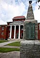
The historic Ashe County Courthouse in Jefferson.
-
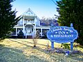
The beautiful Glendale Springs Inn.
-
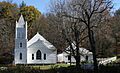
Worth's Chapel, a historic church in Creston.


