
National Register of Historic Places listings in Bourbon County, Kansas facts for kids

Welcome to Bourbon County, Kansas! This article is all about the special places in Bourbon County that are listed on the National Register of Historic Places. This register is like a very important list kept by the United States government. It helps protect buildings, sites, and objects that are important to our country's history, architecture, archaeology, engineering, or culture.
In Bourbon County, there are 13 different places that have made it onto this special list. Many of these historic spots are in the city of Fort Scott, which is a big part of Bourbon County's history. Let's explore some of these amazing places!
Contents
Historic Places in Bourbon County
Fort Scott's Special Spots
Fort Scott is home to many of Bourbon County's historic treasures. These places tell stories about the past and show us how people lived and worked long ago.
First Congregational Church
This beautiful church is located at 502 South National Avenue in Fort Scott. It was added to the National Register on March 23, 2005. Churches like this often have interesting architecture and have been important community centers for many years.
First Presbyterian Church
Another historic church in Fort Scott is the First Presbyterian Church, found at 308 South Crawford Street. It joined the National Register on July 2, 2008. These old churches are often great examples of how buildings were designed in the past.
Fort Scott Downtown Historic District
Imagine a whole area of a city being historic! The Fort Scott Downtown Historic District includes streets from Oak to 3rd Street and Scott Avenue to National Avenue. This district was added to the list on December 18, 2009. It means that many of the buildings in this part of downtown are old and important, showing what the city looked like in earlier times.
Fort Scott National Cemetery
Cemeteries can also be historic places, especially if they hold the graves of important people or tell a story about a time period. The Fort Scott National Cemetery, located at 900 East National Avenue, was listed on July 15, 1999. It is a place of honor and remembrance.
Fort Scott National Historic Site
This is a very important spot! The Fort Scott National Historic Site, on Old Fort Boulevard, was added to the National Register on October 15, 1966. It's a place where you can visit and learn about what life was like at a frontier military fort in the 1840s and 1850s. Soldiers, settlers, and Native Americans all played a part in the history of this area.
Fort Scott Public Carnegie Library
Libraries are often central to a community's learning and history. The Fort Scott Public Carnegie Library, at 201 South National, was listed on August 18, 1987. Carnegie Libraries were built all over the United States with money from Andrew Carnegie, a famous businessman who believed in the power of reading and education.
Moody Building
The Moody Building, located at 15 East 2nd Street in Fort Scott, became a historic listing on November 9, 1977. Old buildings like this often have unique designs and were once busy places for businesses or homes.
Union Block
Another interesting building in Fort Scott is the Union Block, at 24 South Main Street. It was added to the National Register on April 26, 1972. These older buildings help us understand the history of city development and architecture.
Eugene Ware Elementary School
Schools can also be historic! The Eugene Ware Elementary School, at 900 East 3rd Street, was listed on June 9, 2005. This shows that places important for education and community life can also be preserved for their historical value.
Historic Places Outside Fort Scott
Bourbon County has historic places beyond just Fort Scott. These sites also tell important stories about the area's past.
Fulton High School and Grade School
In the town of Fulton, the old Fulton High School and Grade School building, at 408 West Osage Street, was added to the National Register on October 5, 2015. This building served many students over the years and is an important part of Fulton's history.
Long Shoals Bridge
Bridges are often important for connecting communities and allowing travel. The Long Shoals Bridge, located over the Little Osage River east of Fulton, was listed on January 4, 1990. It's an example of an older bridge design that was important for transportation in the area.
Marmaton Bridge
Another historic bridge in Bourbon County is the Marmaton Bridge, about one mile northeast of Fort Scott. It was added to the National Register on May 11, 1982. Bridges like this are often recognized for their engineering or their role in local development.
Images for kids
-
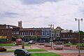
A street view of the Fort Scott Downtown Historic District.
-
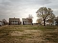
The Fort Scott National Historic Site, showing some of the historic buildings.


