
National Register of Historic Places listings in Broward County, Florida facts for kids
Broward County, Florida, is home to many amazing places that are super important to American history! These special spots are listed on the National Register of Historic Places. Think of it like a Hall of Fame for buildings, areas, and even shipwrecks that tell us stories about the past.

Being on this list means these places are recognized for their history, unique architecture, or cultural importance. It also helps protect them so future generations can enjoy and learn from them. In Broward County, there are 40 such places that are currently listed. One other place was on the list but has since been removed.
Contents
- Cool Historic Places in Broward County
- Historic Homes and Buildings
- Important Community Buildings
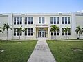
- Croissant Park Administration Building
- Davie School
- Davie Woman's Club
- Deerfield Beach Elementary School
- Hollywood Garden Club
- Hollywood Woman's Club
- Oakland Park Elementary School
- Old Deerfield School
- Old Dillard High School
- New River Inn
- South Side School
- St. Anthony School
- Old West Side Grade School
- Unique Sites and Structures
- Historic Districts
- Former Listings
- Images for kids
Cool Historic Places in Broward County
Let's explore some of the cool historic places you can find in Broward County! Each one has a unique story.
Historic Homes and Buildings
Many of the listed places are old homes or buildings that show us how people lived and worked long ago.
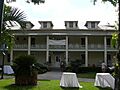
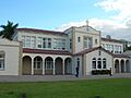
Bonnet House
The Bonnet House is a beautiful estate in Fort Lauderdale. It was built in the 1920s and feels like a step back in time. It's known for its art, nature, and unique architecture.
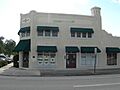
Bryan Building
Located in Fort Lauderdale, the Bryan Building is an important part of the city's early business history. It shows the kind of buildings that were popular when the city was first growing.
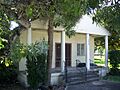
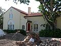
James D. and Alice Butler House
This house in Deerfield Beach is a great example of early 20th-century homes in the area. It tells us about the families who helped build these communities.
Sam Gilliam House
The Sam Gilliam House in Fort Lauderdale is another historic home. It represents the residential styles and community development of its time.
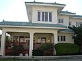
Hammerstein House
In Hollywood, the Hammerstein House is a significant historical residence. It adds to the rich architectural history of the city.
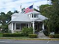
Dr. Willard Van Orsdel King House
This Fort Lauderdale house is named after Dr. Willard Van Orsdel King. It's a notable example of historic homes in the area.
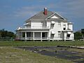
Nyberg-Swanson House
The Nyberg-Swanson House in Dania Beach is a charming historic home. It reflects the early development of Dania Beach.
Alfred and Olive Thorpe Lustron House
This unique house in Fort Lauderdale is a special kind of prefabricated home called a Lustron house. These houses were made from steel and designed to be quickly built after World War II.
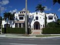
Villa Providence
In Hallandale Beach, the Villa Providence stands as a historic landmark. It showcases the architectural styles of its era.
Williams House
The Williams House in Fort Lauderdale is another important historic residence. It contributes to the understanding of the city's past.
Joseph Wesley Young House
This house in Hollywood belonged to Joseph Wesley Young, who was very important in founding the city of Hollywood. It's a key piece of the city's history.
Important Community Buildings
Many historic places were once centers for learning, community gatherings, or government.
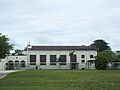
Croissant Park Administration Building
This building in Fort Lauderdale was once the main office for the Croissant Park neighborhood. It shows how communities were planned and managed in the past.
Davie School
The Davie School in Davie is a very old school building. It reminds us of what schools were like for students many years ago.
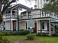
Davie Woman's Club
The Davie Woman's Club was a place where women in Davie gathered for social events, learning, and community service. It shows the important role women played in building their towns.
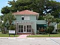
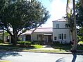
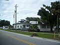
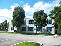
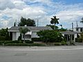
Deerfield Beach Elementary School
This school in Deerfield Beach has been around for a long time. It represents the history of education in the area.
Hollywood Garden Club
The Hollywood Garden Club building was a meeting place for people interested in gardening and beautifying their city. It's a lovely example of community spirit.
Hollywood Woman's Club
Similar to the Davie Woman's Club, the Hollywood Woman's Club was a hub for women's activities and community work in Hollywood.
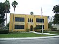
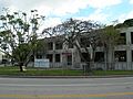
Oakland Park Elementary School
The Oakland Park Elementary School is another historic school building. It has seen many generations of students pass through its doors.
Old Deerfield School
This old school building in Deerfield Beach is a reminder of the early days of schooling in the area.
Old Dillard High School
Old Dillard High School in Fort Lauderdale is very important. It was a school for African American students during a time when schools were segregated. It played a huge role in the community.
New River Inn
The New River Inn in Fort Lauderdale was one of the first hotels in the city. It shows how early tourists and settlers experienced Fort Lauderdale.
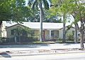
South Side School
The South Side School in Fort Lauderdale is another historic educational building. It served the community for many years.
St. Anthony School
St. Anthony School in Fort Lauderdale is a historic religious school. It has been educating students for a long time.
Old West Side Grade School
This school in Fort Lauderdale, the Old West Side Grade School, also has a long history of educating local children.
Unique Sites and Structures
Not all historic places are buildings. Some are natural sites, lighthouses, or even shipwrecks!
Cap's Place
Cap's Place in Lighthouse Point is a very unique restaurant. It's located on an island and has a long history, including being a secret spot during the Prohibition era.
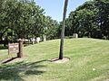
Council Oak Tree Site
The Council Oak Tree Site in Hollywood is a very special place for the Seminole Tribe of Florida. This ancient oak tree was where important tribal meetings and decisions took place. It's a symbol of their history and culture.
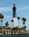
Hillsboro Inlet Light Station
The Hillsboro Inlet Light Station is a tall lighthouse near Pompano Beach. Lighthouses were super important for guiding ships safely along the coast before modern navigation tools existed.
Link Trainer Building
The Link Trainer Building in Fort Lauderdale is a cool piece of aviation history. It was used to train pilots using early flight simulators, called Link Trainers.
Lock No. 1, North New River Canal
This lock in Plantation is part of an old canal system. Canals and locks were built to help control water and make it easier to travel by boat through Florida's waterways.
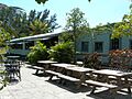
Mai-Kai Restaurant
The Mai-Kai Restaurant in Oakland Park is famous for its unique Polynesian theme, shows, and food. It's a great example of mid-20th-century American culture and entertainment.
Old Seaboard Air Line Railway Station
This old train station in Deerfield Beach was once a busy hub for travelers and goods. It shows the importance of railroads in connecting communities.
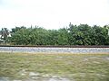
Pompano Beach Mound
The Pompano Beach Mound is an ancient Native American mound. These mounds were built by early people and are important archaeological sites that tell us about their lives and cultures.
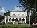
Sample Estate
The Sample Estate in Pompano Beach is a historic property. It represents the grand homes and lifestyles of prominent families in the area's past.
Sample-McDougald House
Another historic house in Pompano Beach, the Sample-McDougald House, is known for its beautiful architecture and history.
SS Copenhagen (shipwreck)
The SS Copenhagen is a shipwreck off the coast of Lauderdale-By-The-Sea. It sank in 1900 and is now an amazing underwater archaeological site, popular with divers. It's like a time capsule at the bottom of the ocean!
Stranahan House
The Stranahan House in Fort Lauderdale is the oldest surviving structure in the city. It was built by Frank Stranahan, who is considered the founder of Fort Lauderdale. It was a trading post, a post office, and a family home.
Historic Districts
Sometimes, a whole area or street is considered historic because it has many important buildings together.
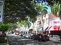
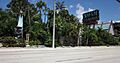
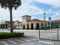
Hollywood Boulevard Historic Business District
This district in Hollywood includes many historic buildings along Hollywood Boulevard. It shows what the city's main street looked like and how businesses operated in the past.
Former Listings
Sometimes, a place that was once on the National Register of Historic Places might be removed. This can happen for different reasons, like if the building is changed too much or if it's no longer considered historically significant.
Dr. Kennedy Homes Historic District
The Dr. Kennedy Homes Historic District in Fort Lauderdale was once listed. It was a neighborhood with a special history, but it is no longer on the list.
Images for kids
-
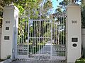
The entrance to Bonnet House in Fort Lauderdale.
-
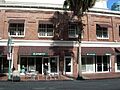
The historic Bryan Building in Fort Lauderdale.
-
The James D. and Alice Butler House in Deerfield Beach.
-
Cap's Place, a unique restaurant in Lighthouse Point.
-
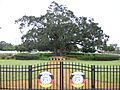
The Council Oak Tree Site, important to the Seminole Tribe.
-
The Croissant Park Administration Building.
-
The old Davie School building.
-
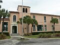
Deerfield Beach Elementary School.
-
The Sam Gilliam House in Fort Lauderdale.
-
The Hammerstein House in Hollywood.
-
The Hillsboro Inlet Light Station.
-
Buildings in the Hollywood Boulevard Historic Business District.
-
The Hollywood Garden Club building.
-
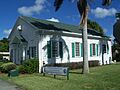
The Hollywood Woman's Club.
-
The Dr. Willard Van Orsdel King House.
-
The Link Trainer Building.
-
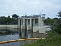
Lock No. 1 on the North New River Canal.
-
The Mai-Kai Restaurant.
-
The historic New River Inn.
-
The Nyberg-Swanson House in Dania Beach.
-
Oakland Park Elementary School.
-

The Old Deerfield School.
-
Old Dillard High School.
-
The Old Seaboard Air Line Railway Station.
-
The Pompano Beach Mound.
-
St. Anthony School.
-
The Sample Estate.
-
The Sample-McDougald House.
-
South Side School.
-
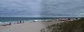
The SS Copenhagen shipwreck underwater.
-
The Stranahan House.
-
The Alfred and Olive Thorpe Lustron House.
-
Villa Providence in Hallandale Beach.
-
The Old West Side Grade School.
-
The Williams House.
-
The Joseph Wesley Young House.
-
The Dr. Kennedy Homes Historic District (former listing).


