
National Register of Historic Places listings in Butte County, South Dakota facts for kids

Welcome to Butte County, South Dakota! Did you know that this county is home to many special places that are important to history? These places are so important that they are listed on the National Register of Historic Places. This is like a special list kept by the United States government to protect and celebrate buildings, sites, and objects that have played a big part in our country's story.
When a place is on this list, it means it's recognized for its historical, architectural, or archaeological importance. It helps make sure these cool spots are preserved for future generations, like you! In Butte County, there are 39 places currently on this list. Some others were once listed but have since been removed. Let's explore some of these amazing historic sites!
Contents
Historic Places in Butte County
Butte County has a rich history, and many of its buildings and sites tell stories of the past. From old schools to important dams, these places show us how people lived, worked, and built communities long ago.
Buildings and Homes with History
Many of the historic places in Butte County are buildings where people lived, worked, or gathered.
- Belle Fourche Band Shell: This cool outdoor stage in Herrmann Park, Belle Fourche, was added to the list in 2016. It's a place where people have enjoyed music and performances for many years.
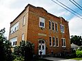
- Belle Fourche Commercial Historic District: This area in Belle Fourche, listed in 1982, includes several old buildings on State Street and 5th Avenue. These buildings show what the town's main street looked like when it was first growing.

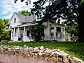
- Charles Bolles House: Located in Belle Fourche, this house was built a long time ago and was added to the list in 1982. It's a great example of the homes from that era.

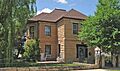
- Butte County Courthouse and Historic Jail Building: The main courthouse for Butte County in Belle Fourche, along with its old jail, became historic landmarks in 1998. These buildings have been central to the county's government and justice system for many years.

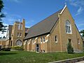
- First Congregational United Church of Christ: This church in Belle Fourche, listed in 2013, is an important part of the community's spiritual and social history.

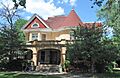
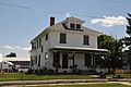
- Thomas Haskins Gay House: Another historic home in Belle Fourche, this house was recognized in 1982.

- Fred S. Harris House: This house in Belle Fourche, listed in 1988, is another example of the early architecture in the area.

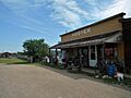
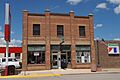
- Hoover Store: Located in Hoover, this old store was listed in 1986. It reminds us of the small general stores that were once vital to rural communities.

- Alexander Hoover House: Also in Hoover, this house was listed in 1986, showing another piece of the town's early life.
- William Johnson House: This historic house in Fruitdale was added to the list in 1986.
- William G. Kenaston House: Located in Newell, this house became a historic site in 1984.
- Lincoln School: This old school building in Belle Fourche, listed in 2001, played a big role in educating generations of local children.

- Newell High School: The high school in Newell was recognized as historic in 1986.
- John Aaron Scotney House: This house in Belle Fourche was listed in 1978.

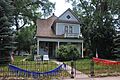
- Charles and Eleanor Small House: This Belle Fourche home was added to the list in 1991.

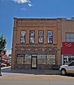
- Tri State Bakery: This bakery building in Belle Fourche, listed in 1993, is a reminder of the businesses that served the community.

- Wide Awake Grocery Building: This old grocery store in Belle Fourche was recognized in 1978.

Important Bridges and Dams
Butte County also has several historic bridges and a significant dam that are on the National Register. These structures were crucial for travel, trade, and farming in the region.
- Belle Fourche Dam: East of Belle Fourche, this large dam was listed in 1977. It's a very important part of the local irrigation system, helping farmers grow crops.

- Hay Creek Bridge: This bridge in Belle Fourche, built over Hay Creek, was listed in 1993.
- Minnesela Bridge: Located over Redwater Creek near Belle Fourche, this bridge was recognized in 1993.
- Newell Depot Bridge: This bridge over Horse Creek in Newell was added to the list in 1999.
- South Dakota Dept. of Transportation Bridge No. 10-109-360: This bridge in the Belle Fourche Irrigation District was listed in 1993.
- South Dakota Dept. of Transportation Bridge No. 10-270-338: Another bridge over Horse Creek near Newell, listed in 2000.
- Stonelake Bridge: This bridge near Newell was recognized in 1986.
- Vale Bridge: This bridge over the Belle Fourche River near Vale was added to the list in 1999.
- Vale Cut Off Belle Fourche River Bridge: Southwest of Newell, this bridge was listed in 1986.
Farms and Ranches
Farming and ranching have always been a huge part of life in Butte County. Some of these historic agricultural sites are also on the National Register.
- Belle Fourche Experiment Farm: Northwest of Newell, this farm was listed in 1976. It was an important place for studying new farming methods and crops.
- Carl Friedrick Gartner Homestead: This historic farm west of Highway 79 near Newell was recognized in 1986. Homesteads like this show how early settlers built their lives in the area.
- Soper-Behymer Ranch: This ranch near Belle Fourche was listed in 1986. Ranches are a big part of South Dakota's heritage.
- Nicholas Augustus Viken Homestead: Another homestead near Newell, this one was added to the list in 1986.
Other Interesting Historic Sites
Butte County also has other unique places that are important to its history.
- Butte-Lawrence County Fairgrounds: Southwest of Nisland, these fairgrounds were listed in 1986. Fairs have always been a fun and important gathering place for communities.
- Ditchrider House: North of U.S. Route 212 near Nisland, this house was listed in 2002. Ditchriders were important people who managed the water flow for irrigation.
- Fruitdale School: This old school in Fruitdale was recognized in 1986, showing the importance of education in early communities.
- Fruitdale Store: The store in Fruitdale, listed in 1986, was a central spot for people to buy supplies and meet.
- Langdon School: Another historic school near Nisland, listed in 1986.
- Snoma Finnish Cemetery: Southeast of Fruitdale, this cemetery was listed in 1985. It's a quiet place that tells the story of the Finnish people who settled in the area.
Former Listings
Sometimes, places that were once on the National Register of Historic Places are removed from the list. This can happen for different reasons, like if a building is changed too much or if it is no longer standing. In Butte County, five properties were once listed but are no longer on the Register.
Images for kids
-
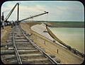
Belle Fourche Dam during construction.
-
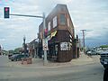
A building in the Belle Fourche Commercial Historic District.
-
The historic Charles Bolles House.
-
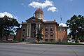
The Butte County Courthouse.
-
The First Congregational United Church of Christ.
-
The Thomas Haskins Gay House.
-
The Fred S. Harris House.
-
The Hoover Store.
-
The Lincoln School.
-
The John Aaron Scotney House.
-
The Charles and Eleanor Small House.
-
The Tri State Bakery building.
-
The Wide Awake Grocery Building.
