
National Register of Historic Places listings in Chaves County, New Mexico facts for kids

Welcome to Chaves County, New Mexico! This area is home to many special places that are listed on the National Register of Historic Places. Think of this register as a very important list of buildings, sites, and objects across the United States that are worth saving. These places tell us stories about the past. They show us how people lived, worked, and built things long ago.
In Chaves County, there are 20 different places on this list. Each one helps us understand the history of New Mexico and the people who lived here. By protecting these sites, we make sure that future generations can learn from them too. It's like having a giant history book spread out across the county!
Contents
Discovering Chaves County's Historic Treasures
Chaves County has many cool spots that are part of the National Register of Historic Places. These places are important because they show us what life was like in the past. They help us understand the history of the area.
Important Buildings and Homes
Some of the historic places are buildings where important things happened or where interesting people lived.
Chaves County Courthouse
The Chaves County Courthouse is a grand building in Roswell. It's where many important decisions for the county have been made over the years. Courthouses are often central to a community's history. This one has stood for a long time, watching the town grow and change.
Louise Massey House
The Louise Massey House is another special home in Roswell. It belonged to Louise Massey, a famous country singer. She was known for her music and for being a pioneer in country and western swing. Imagine living in a house where a music star once created songs!
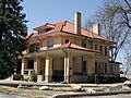
James Phelps White House
The James Phelps White House is also in Roswell. James Phelps White was an important person in the early days of the area. His home is a great example of the architecture from that time. It helps us see how people built their houses many years ago.
Historic Ranches and Farms
Chaves County is known for its wide-open spaces and ranching history. Several ranches and farms are on the National Register.
CA Bar Ranch
The CA Bar Ranch is located west of Mayhill. Ranches like this played a huge role in the development of New Mexico. They show us how people managed land and raised animals in the past.
Diamond A Ranch
The Diamond A Ranch is another historic ranch near Roswell. These large ranches were often like small communities themselves. They were important for the economy and culture of the region.
Flying H Ranch
The Flying H Ranch is also near Roswell. These ranches represent the spirit of the American West. They remind us of the hard work and adventurous lives of early settlers and ranchers.
Special Districts and Landmarks
Sometimes, a whole area or a unique landmark can be historic.
Downtown Roswell Historic District
The Downtown Roswell Historic District includes a large part of the city's center. This area has many old buildings that together tell the story of Roswell's growth. Walking through it is like stepping back in time.
New Mexico Military Institute Historic District
The New Mexico Military Institute Historic District is a significant part of Roswell. This institute is a famous military school. Its historic buildings show its long history of educating young people.
Ozark Trails Marker at Lake Arthur
The Ozark Trails Marker at Lake Arthur is a unique landmark. It marks a historic road system that connected different parts of the country. These markers helped travelers find their way long before modern highways.
Rio Felix Bridge At Hagerman
The Rio Felix Bridge At Hagerman is an old bridge over the Rio Felix. Bridges are important for connecting communities. This one shows us how engineers built structures to cross rivers many years ago.
Images for kids
-
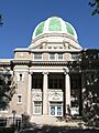
The Chaves County Courthouse in Roswell.
-
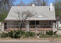
The historic Louise Massey House.
-
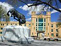
Buildings at the New Mexico Military Institute.
-
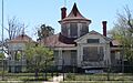
The Saunders-Crosby House.
-
The James Phelps White House, now a historical museum.


