
National Register of Historic Places listings in Chelan County, Washington facts for kids

This article is a list of special places in Chelan County, Washington that are part of the National Register of Historic Places. This register is like a national scrapbook of important buildings, sites, and objects that have played a big role in American history, architecture, archaeology, engineering, or culture. When a place is added to this list, it means it's recognized as important and efforts are made to protect it.
In Chelan County, there are 48 places currently on this list. One other place was on the list but has since been removed.
Contents
Historic Places in Chelan County
Chelan County is home to many interesting historic sites. These places tell stories about the past, from early settlements and mining to important buildings and natural areas.
Old Buildings and Homes
Many buildings in Chelan County have been recognized for their history.
- Black Warrior Mine
* This old mine is located north of Stehekin in the North Cascades National Park. It was added to the list in 1974.
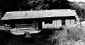
- Bridge Creek Cabin-Ranger Station
* Found near Bridge Creek Campground, this cabin and ranger station were listed in 1989.
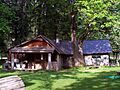
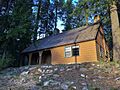
- Buckner Cabin
* This cabin is in the Lake Chelan National Recreation Area near Stehekin. It became a historic place in 1974.
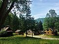
- Buckner Homestead Historic District
* This is a group of historic buildings that make up the Buckner Homestead, also near Stehekin. It was listed in 1989.
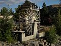
- Burbank Homestead Waterwheel
* Located in Cashmere, this waterwheel from the Burbank Homestead was added to the list in 1973.
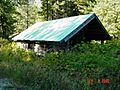
- Chatter Creek Guard Station
* This guard station is in the Wenatchee National Forest near Leavenworth. It was listed in 1986.
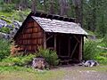
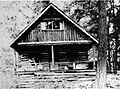
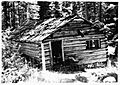
- Courtney Cabin
* Another historic cabin in the Lake Chelan National Recreation Area near Stehekin, listed in 1974.
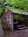
- Flick Creek Shelter
* This shelter is on the east side of Lake Chelan, south of Flick Creek. It was added to the list in 1989.
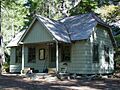
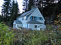
- George Miller House
* This house is on the east side of Lake Chelan on Stehekin Valley Road. It became a historic place in 1989.
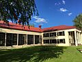
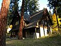
- High Bridge Ranger Station Historic District
* This group of buildings is part of the High Bridge Ranger Station on Stehekin Valley Road. It was listed in 1989.
- High Bridge Shelter
* Located at High Bridge Campground, this shelter was added to the list in 1989.
- Lake Wenatchee Residence No. 1200
* This residence is on the north shore of Lake Wenatchee in the Wenatchee National Forest. It was listed in 1991.
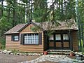
- Leavenworth Ranger Station
* This ranger station is in the Wenatchee National Forest near Leavenworth. It became a historic place in 1986.
- Lucerne Guard Station
* This guard station is on the south shore of Lake Chelan in the Wenatchee National Forest. It was listed in 1991.
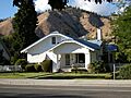
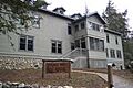
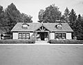
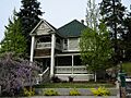
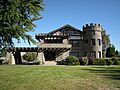
- Michael Horan House
* Located in Wenatchee, this house was added to the list in 1992.
- Purple Point-Stehekin Ranger Station House
* This ranger station house is on the east side of Lake Chelan. It was listed in 1989.
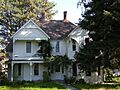
- Richard Hinton Lord House
* This house in Chelan was added to the list in 1999.
- Stehekin School
* This old school building is in the Lake Chelan National Recreation Area. It became a historic place in 1974.
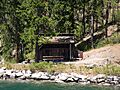
- Steliko Ranger Station
* This ranger station is east of the Entiat River in the Wenatchee National Forest. It was listed in 1991.
- Stevens Pass Guard Station
* Located at Stevens Pass, this guard station was added to the list in 1991.
- Sulphide-Frisco Cabin
* This cabin is on the Bridge Creek Trail, north of Stehekin Valley Road. It was listed in 1989.
- U.S. Post Office and Annex
* This historic post office building in Wenatchee was added to the list in 1977.
- Wells House
* This house in Wenatchee became a historic place in 1973.
- Wenatchee Carnegie Library
* This old library building in Wenatchee was listed in 1982.
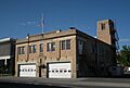
- Wenatchee Fire Station #1
* The first fire station in Wenatchee was added to the list in 2004.
Historic Districts and Areas
Some areas with many historic buildings are listed together as a "historic district."
- Cottage Avenue Historic District
* This district in Cashmere includes several historic buildings on Cottage Avenue, Maple Street, and Parkhill Street. It was listed in 2002.
- Downtown Wenatchee Historic District
* This area in downtown Wenatchee, roughly bounded by Columbia, Mission, N. 1st, and Kittitas Streets, became a historic district in 2008.
- Golden West Lodge Historic District
* This district is located at Stehekin Landing and was listed in 1989.
- Leavenworth Ski Hill Historic District
* This historic ski area at the junction of Ski Hill Drive and Titus Road in Leavenworth was added to the list in 2013.
- Stevens Pass Historic District
* This district is west of Berne on U.S. 2 and was listed in 1976.
Important Bridges
Several bridges in Chelan County are recognized for their engineering and historical importance.
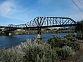
- Columbia River Bridge
* This bridge spans the Columbia River between Wenatchee and East Wenatchee. It was listed in 1982.
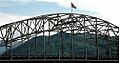
- Senator George Sellar Bridge
* Also known as the George Sellars Bridge, this bridge carries U.S. 2 over the Columbia River in Wenatchee. It was added to the list in 1995.
- Penstock Bridge
* This bridge spans the Wenatchee River north of Leavenworth on U.S. 2. It was listed in 1982.
- Rock Island Railroad Bridge
* This railroad bridge crosses the Columbia River southwest of Rock Island. It became a historic place in 1975.
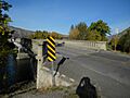
- West Monitor Bridge
* This bridge spans the Wenatchee River near Monitor. It was added to the list in 1982.
Other Unique Historic Sites
Chelan County also has other interesting historic sites.
- Chelan Butte Lookout
* This lookout tower on the summit of Chelan Butte was listed in 1990.
- Leavenworth National Fish Hatchery
* This fish hatchery in Leavenworth was added to the list in 1998.
- Lake Chelan Hydroelectric Power Plant
* This power plant on Lake Chelan was listed in 1988.
- Lucas Homestead
* This homestead southwest of Chelan was added to the list in 1978.
- Ruby Theatre
* This historic theater in Chelan was listed in 1991.
- St. Andrews Episcopal Church
* This church in Chelan became a historic place in 1992.
- Sugarloaf Peak Lookout
* This lookout tower on the summit of Sugarloaf Peak was listed in 1990.
- Tyee Mountain Lookout
* This lookout tower on the summit of Tyee Mountain was added to the list in 1990.
- Wenatchee Flat Site
* This site in Wenatchee was listed in 1973, but its exact address is restricted for protection.
Former Listings
Sometimes, a place is removed from the National Register of Historic Places. This can happen if the building is destroyed or changed so much that it no longer has its historic value.
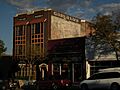
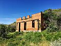
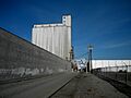
- Centennial Flour Mill
* This flour mill in Wenatchee was listed in 1976 but was removed from the list in 1990.
Images for kids
-

The Blewett Arrastra, an old gold-processing machine.
-
The Bridge Creek Shelter.
-
The Buzzard Cabin at Buckner Homestead.
-
The main residence at Buckner Homestead.
-
The Burbank Homestead Waterwheel in Cashmere.
-
The Chatter Creek Guard Station.
-
The Chelan Butte Lookout.
-
The Columbia River Bridge in Wenatchee.
-
The Senator George Sellar Bridge.
-
A building in the Cottage Avenue Historic District.
-
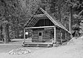
The Courtney Cabin.
-
Garland Apartments in the Downtown Wenatchee Historic District.
-
The Flick Creek Shelter.
-
The Golden West Visitor Center.
-
The High Bridge Ranger Station.
-
The High Bridge Shelter.
-
The Michael Horan House.
-
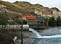
The Lake Chelan Hydroelectric Power Plant.
-
Lake Wenatchee Residence No. 1200.
-
The Leavenworth National Fish Hatchery.
-
The Leavenworth Ranger Station.
-
The Leavenworth Ski Hill.
-
The Richard Hinton Lord House.
-
The Lucas Homestead.
-

The Lucerne Guard Station.
-
The George Miller House.
-
The Penstock Bridge.
-

The Purple Point-Stehekin Ranger Station House.
-
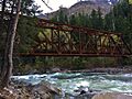
The Rock Island Railroad Bridge.
-

The Ruby Theatre in Chelan.
-
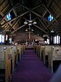
Inside St. Andrews Episcopal Church.
-
The Stehekin School.
-
The Steliko Ranger Station.
-
The Stevens Pass Guard Station.
-
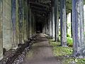
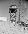
A snowshed at Stevens Pass.
-
The Sulphide-Frisco Cabin.
-

The old U.S. Post Office and Annex in Wenatchee.
-
The Wells House in Wenatchee.
-

The Wenatchee Carnegie Library.
-
Wenatchee Fire Station #1.
-

Image for a restricted address site.
-
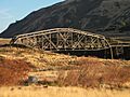
The West Monitor Bridge.
-
The Centennial Flour Mill (formerly listed).


