
National Register of Historic Places listings in Chippewa County, Michigan facts for kids

Chippewa County in Michigan is home to many amazing places that are listed on the National Register of Historic Places. This special list includes buildings, sites, and objects that are important to American history, architecture, archaeology, engineering, and culture. Think of it like a hall of fame for historic spots!
These places are recognized because they tell important stories about the past. In Chippewa County, there are 28 such places. Let's explore some of these cool historic sites!
Contents
Historic Buildings in Sault Ste. Marie
Sault Ste. Marie, often called "the Soo," has many old and interesting buildings.
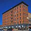
Adams Building

The Adams Building was built in 1903 by Robert N. Adams. It was first used for businesses and offices. Part of the first floor was even a bank called Central Savings Bank until 1975. Today, this building and the one next to it, the Gowan Block, are part of a big project called Park Place City Center. It has both shops and homes.
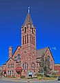
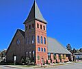
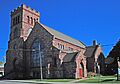
Central United Methodist Church

This beautiful church was built between 1892 and 1894. It's made from local red sandstone, which was dug up for a canal project that didn't happen. Even though the church has had three fires over the years, its outside looks almost exactly the same as when it was first built. It's a great example of old-style architecture.
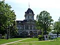
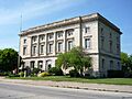
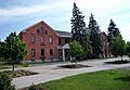
Chippewa County Courthouse

The Chippewa County Courthouse is a large, three-story building made of cut stone. It was designed by an architect from Detroit and built in 1877. Later additions in 1904 and around 1930 matched the original style perfectly. This courthouse is one of the oldest ones in Michigan that is still being used today!
Old Federal Building

This building, made of limestone, was constructed between 1909 and 1910. It used to be a post office and a courthouse until 1941. In 1992, a group bought the building and turned it into the River of History Museum. It's a great place to learn about the area's history.
First United Presbyterian Church

The First United Presbyterian Church has a long history in Sault Ste. Marie, going back to 1823. The current large church building was built in 1902-1903 using special Jacobsville Sandstone. Sadly, this church was destroyed by fire in 2000 but was rebuilt in 2002.
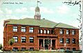
Garfield School

The Garfield School is another historic building in Sault Ste. Marie. It was added to the National Register in 2022, showing its importance to the community's history.
Gowan Block

The Gowan Block was built in 1901 as a place for businesses and meetings. It was used by a hardware store and a local Masonic Lodge. Like the Adams Building, it's now part of the Park Place City Center, a modern development with shops and homes.
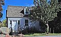
John Johnston House

The original part of this house was built in 1815 by John Johnston, a fur trader and an early settler of Sault Ste. Marie. He built it after his first house was burned during the War of 1812. In 1822, he added a section for his daughter Jane and her husband, Henry Rowe Schoolcraft. In 1910, a tree fell on the house, destroying the oldest part. Only the 1822 addition remains today.
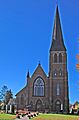
Saint James' Episcopal Church

Saint James' Episcopal Church is a beautiful church built in 1902-1903. It's made of red-brown sandstone and has a special cross-shaped design. The church is still used by the Episcopal community today.
St. Mary's Pro-Cathedral

Holy Name of Mary Pro-Cathedral is the main church for the Catholic Diocese of Marquette. The current church building, which is the fifth one for this church group, was built in 1881. It was designed by a Canadian architect in a style that looks like old Gothic churches.
Important Sites on Sugar Island
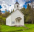
Church of Our Saviour, Friend of Children

This church, also known as Holy Angels Roman Catholic Church, was built in 1856-57. Regular church services were held here until 1953. Since 1982, summer services have been held. This church is the last building left from an old settlement called Payment Settlement.
Philetus S. Church House

This house is the last building from Church's Landing, which was a trading post and steamboat stop started by Philetus S. Church in 1846. Church sold many things, like furs, maple syrup, vegetables, and even tons of raspberry jam! His son built this house for him in 1862. After Church retired and passed away, the settlement slowly disappeared.
Lighthouses and Bridges
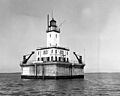
DeTour Reef Light Station

A lighthouse was first put at the southern entrance of the DeTour Passage in 1847. The lighthouse you see today was built in 1931 right on top of DeTour Reef. It became automatic in 1974, meaning it didn't need a person to operate it anymore. A special group now owns and takes care of the lighthouse.
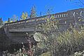
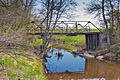
M-28 – Tahquamenon River Bridge

This bridge over the Tahquamenon River was built in 1926. It's special because it's one of only two bridges in Michigan that has concrete covering all its support beams. It was a kind of "prototype" for many other bridges built in Michigan over the next ten years.
Parker Road – Charlotte River Bridge

This bridge, also known as the 10 Mile Road – Charlotte River Bridge, was built in 1914. It's a type of truss bridge, which means it uses a framework of triangles to make it strong. What's interesting is that its parts are made of pairs of steel angles, which made it cheaper to build.
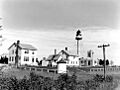
Point Iroquois Light Station

The first lighthouse at Point Iroquois was built in 1855-57, but it wasn't good enough. The current lighthouse was built in 1870 and was used until 1962. It was renovated in 1993 and is a great place to visit.
Whitefish Point Lighthouse

First lit in 1849, the Whitefish Point Light was one of the very first lighthouses on Lake Superior. It's also the oldest active lighthouse on the lake! The current lighthouse, built in 1861, looks modern but is actually a Civil War-era structure. Its iron frame was designed to stand strong against high winds.
Other Notable Historic Places
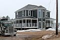
Birch Lodge

Birch Lodge was built in 1912. It started as a mix of a summer resort and a place for people with tuberculosis to get better. It had some financial problems early on, but by 1926, it became a resort. It stayed open until 2006 and then reopened in 2010. It's a great example of what resorts looked like in the early 1900s.
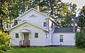
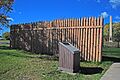
Kinross Township Hall and School

The Kinross Township Hall and School was built in 1905. It used to be an important building for the township and a school. It's no longer used by the township and was sold to a private owner in 2010.
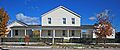
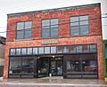
Lipsett Hardware Building

The Lipsett Hardware Building was built in 1912 and was a hardware store until 1982. In 2001, the Pickford Area Historical Society bought the building. They fixed up the front of the building, and now it's a museum! The first floor still has its original, beautiful tin ceiling.
Fort Drummond

After the War of 1812, British soldiers had to leave Fort Mackinac. In 1815, they moved to Fort Drummond on Drummond Island, thinking it was still British land. They built a settlement there. But in 1822, it was decided that Drummond Island was actually part of the United States! The British stayed until 1828, and then the settlement was left empty. Today, you can still see some old chimneys and hearths.
Naomikong Point Site
The Naomikong Point Site is a very old archaeological site. It's where people lived a long, long time ago during the Late Woodland period. More than 100,000 pieces of pottery were found here, showing that many different pots were used.
New Fort Brady

New Fort Brady was built in 1893 on a hill above the older Fort Brady. It was an Army fort until 1946. Today, the land and buildings are the main part of Lake Superior State University.
Old Fort Brady

In 1822, Colonel Hugh Brady started Fort Brady in Sault Ste. Marie to protect against British attacks from Canada. No more fighting happened there, so the Army left the original fort. But they came back and rebuilt it in 1866 to protect the nearby Soo Locks and canals. In 1893, the soldiers moved to the new site, which is now Lake Superior State University.
Sault Ste. Marie Historic Commercial District

This district includes several streets in Sault Ste. Marie that are important for their history of businesses and trade. It shows how the city grew and developed over time as a center for commerce.
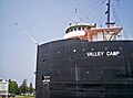
S.S. Valley Camp

The S.S. Valley Camp is a large freighter boat that was launched in Ohio in 1917. It's about 550 feet long! This ship worked on the Great Lakes for almost 50 years. In 1968, it was turned into a museum ship, so people can now visit it and learn about life on a Great Lakes freighter.
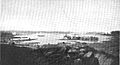
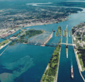
St. Mary's Falls Canal (Soo Locks)

The St. Mary's Falls Canal, also known as the Soo Locks, is a very important canal that helps ships travel between Lake Superior and Lake Huron. The first locks were finished in 1855. They were run by Michigan until the U.S. Army took over in 1881. The locks you see today were built between 1895 and 1943 and are a marvel of engineering!
Images for kids
-
The Adams Building in Sault Ste. Marie
-
Birch Lodge
-
The Central United Methodist Church
-
The Chippewa County Courthouse
-
The Church of Our Saviour, Friend of Children on Sugar Island
-
The Philetus S. Church House
-
The DeTour Reef Light Station
-
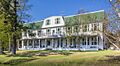
Elmwood, also known as the Schoolcraft House
-
The Old Federal Building, now the River of History Museum
-
The First United Presbyterian Church
-
An illustration of Fort Drummond
-
The Garfield School building
-

The Gowan Block
-
The John Johnston House
-
The Old Kinross Township Hall
-
The Lipsett Hardware Building
-
The M-28 bridge over the Tahquamenon River
-
South Hall at Lake Superior State University, part of New Fort Brady
-
Old Fort Brady
-
The Parker Road – Charlotte River Bridge
-

The Point Iroquois Light Station
-
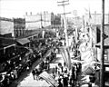
Sault Ste. Marie Canal celebration around 1905
-
The bow of the S.S. Valley Camp
-
Saint James' Episcopal Church
-
The Soo Locks
-
St. Mary's Pro-Cathedral
-
The Whitefish Point Lighthouse

