
National Register of Historic Places listings in Claiborne County, Tennessee facts for kids

Welcome to Claiborne County, Tennessee! This special place is home to many buildings and areas that are super important to American history. These sites are so valuable that they've been added to the National Register of Historic Places. Think of it like a national hall of fame for historic buildings, districts, and sites!
The National Register of Historic Places is a list kept by the United States government. It helps protect and celebrate places that tell us about the past. In Claiborne County, there are 12 different places on this list. Two other places were once listed but are not anymore. Let's explore some of these amazing historic spots!
Historic Places in Claiborne County
Big Spring Union Church: A Place of Worship

The Big Spring Union Church is a beautiful old church located off State Route 32 in Springdale. It's also known as the Big Springs Primitive Baptist Church. This church has been a central part of the community for a very long time, offering a place for people to gather and worship. It was added to the National Register in 1975.
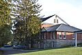
Claiborne County Jail: A Look at the Past

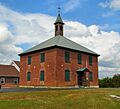
In Tazewell, you can find the old Claiborne County Jail at the corner of State Route 33 and U.S. Route 25E. This building served as the county jail for many years. It stands as a reminder of how law and order were managed in the past. It became a historic landmark in 2007.
Cumberland Gap: A Famous Mountain Pass


The Cumberland Gap is one of the most famous places in American history! It's a natural pass through the Appalachian Mountains. For hundreds of years, Native Americans used this path. Later, pioneers like Daniel Boone used it as part of the Wilderness Road to settle new lands in Kentucky and beyond.
There are a few important historic listings related to Cumberland Gap:
- The Cumberland Gap Historic District in the town of Cumberland Gap, Tennessee, protects the historic buildings and streets of this important town. It was listed in 1990.
- The larger Cumberland Gap Historic District covers the actual mountain pass itself. This huge area stretches across Tennessee, Kentucky, and Virginia. It was recognized in 1980 for its role in American expansion.
- The Cumberland Gap National Historical Park is a national park that protects this entire historic area. It was established to preserve the natural beauty and rich history of the gap. It became a National Historical Park in 1966.
Graham-Kivette House: An Old Home in Tazewell

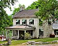
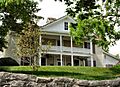
The Graham-Kivette House is a very old home in Tazewell, found at the junction of Main Street and Old Knoxville Road. It was built around 1810 by William Graham. Later, the Kivett family lived there for many years. This house gives us a peek into what homes looked like over 200 years ago! It joined the National Register in 1975.
Grant-Lee Hall: A University Landmark

On the campus of Lincoln Memorial University in Harrogate, you'll find Grant-Lee Hall. This important building is a key part of the university's history. Universities often have historic buildings that have seen many generations of students pass through their doors. Grant-Lee Hall was added to the National Register in 1978.
Historic Homes in Speedwell
Speedwell, Tennessee, is home to several historic houses that tell stories of early settlers and families.
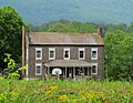
- The Kincaid House (also known as the Kincaid-Russell House) is northeast of Speedwell on Russell Lane. It was built around 1840 by John Kincaid II for his brother. It was listed in 1982.
- The Kincaid-Ausmus House is another Kincaid family home, built in 1851 by John Kincaid II for his son, John Kincaid III. It's northeast of Speedwell off State Route 63 and was listed in 1975.
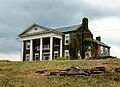
- The McClain-Ellison House is west of Speedwell, off State Route 63. This house is even older, built in the 1790s by Thomas McClain! The Ellison family lived there in the 20th century. It became a historic site in 1975.
Powell Valley Male Academy: An Early School

Also in Speedwell, at the junction of Old State Route 63 and Academy Road, is the Powell Valley Male Academy. This building, also known as Speedwell Academy, was built in 1827. It was an early school for boys, showing how important education was to the communities back then. It was added to the National Register in 1995.
Images for kids
-
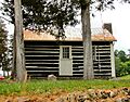
Big Spring Union Church
-
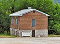
The historic Claiborne County Jail
-
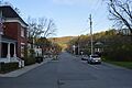
Colwyn Avenue in the Cumberland Gap Historic District
-
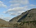
The historic Cumberland Gap
-

Cumberland Gap National Historical Park
-
The historic Graham-Kivette House
-
Grant-Lee Hall at Lincoln Memorial University
-
The historic Kincaid House in Speedwell
-
The historic Kincaid-Ausmus House
-
The historic McClain-Ellison House
-
The historic Powell Valley Male Academy


