
National Register of Historic Places listings in East and Northeast Baltimore facts for kids
The National Register of Historic Places is an official list of places in the United States that are important to American history. These places can be buildings, sites, structures, objects, or even entire neighborhoods. When a place is added to this list, it means it's recognized for its special historical or architectural value. This list focuses on some of these amazing historic places found within the city of Baltimore, Maryland. It's important to know that Baltimore is a special city that isn't part of any county, even though it's surrounded by Baltimore County.
Contents
Discovering Baltimore's Historic Treasures
Baltimore is a city full of history, and many of its old buildings and areas are protected. These places tell stories about how people lived, worked, and built the city over many years. Let's explore some of these cool spots that are on the National Register of Historic Places.
Historic Buildings with Unique Stories
Many buildings in Baltimore have been saved because they are so special. They show us different styles of architecture and how the city grew.
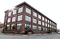
The American Brewery
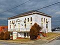
The American Brewery building, located at 1701 N. Gay St., is a great example of old industrial architecture. It was built in 1887 and used to be a place where beer was made. Today, it has been beautifully restored and is used for offices. It's a reminder of Baltimore's past as a busy manufacturing city.

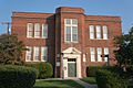
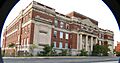
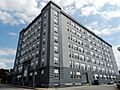
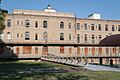
Baltimore City College
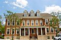
Baltimore City College is a very old and famous public high school. Its building at 3320 The Alameda was built in 1928. It looks like a grand castle and is known for its beautiful Gothic Revival style. Many important people have studied here, making it a significant part of Baltimore's educational history.
.jpg)
Engine House No. 6
Engine House No. 6 at 416 N. Gay St. is an old fire station. It was built in 1853 and is one of the oldest firehouses in the city. It shows how fire departments used to operate and how important they were for keeping the city safe. It's a cool piece of Baltimore's public service history.

Old Town Savings Bank
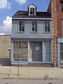
The Old Town Savings Bank at 353 N. Gay St. is a beautiful building known for its cast-iron front. Cast-iron architecture was popular in the 1800s because it allowed buildings to have large windows and decorative details. This bank building is a great example of this unique style in Baltimore.

Public School No. 99
Public School No. 99 at E. North Ave. and N. Washington St. is another historic school building. It was built in 1890 and is a good example of the large, impressive schools built in Baltimore during that time. These schools were important for educating many generations of Baltimore's children.

Green Spaces and Quiet Places
Not all historic places are buildings. Some are parks, cemeteries, or even parts of neighborhoods that have kept their original look and feel.
Bohemian National Cemetery
The Bohemian National Cemetery at 1300 Horners Lane is a historic burial ground. It was established in 1886 by the Bohemian community in Baltimore. Cemeteries like this are important because they show us how different groups of people settled in the city and how they honored their loved ones.

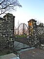
Clifton Park
Clifton Park is a large, historic park in Baltimore. It was once the estate of a wealthy merchant and politician named Johns Hopkins. The park includes beautiful landscapes and historic structures like the Clifton Mansion. It's a wonderful place for recreation and to learn about Baltimore's past.

Green Mount Cemetery
Green Mount Cemetery is a famous historic cemetery bounded by North and Greenmount Aves. It was founded in 1838 and is known for its beautiful monuments and famous people buried there. Many important figures from Baltimore's history rest here, making it a significant historical site.

Historic Neighborhoods and Districts
Sometimes, an entire area or neighborhood is considered historic because it has many old buildings that together tell a story.
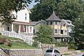
Arcadia-Beverly Hills Historic District
The Arcadia-Beverly Hills Historic District is a neighborhood recognized for its unique character. It includes homes and streets that show how Baltimore grew in the early 20th century. Walking through this district is like taking a step back in time to see how people lived in those days.

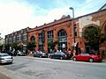
Brewers Hill Historic District
The Brewers Hill Historic District is named for the old breweries that used to be in the area, like the famous National Bohemian Brewery. This district shows the industrial past of Baltimore and how old factory buildings can be given new life. It's a vibrant area with a lot of history.

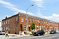
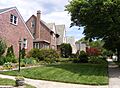
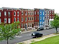
Old East Baltimore Historic District
The Old East Baltimore Historic District is a large area with many historic homes and buildings. It shows the typical rowhouse style that Baltimore is famous for. This district tells the story of how many working-class families lived and built communities in the city.

These are just a few examples of the many historic places in Baltimore that are listed on the National Register. Each one helps us understand the rich and diverse history of this amazing city.
Images for kids
-
The Clifton Park Valve House.
-
The historic Clifton School building.
-
The former Coca-Cola Bottling Company building.
-
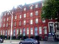
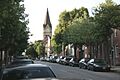
A street view in the East Monument Historic District.
-
The peaceful Friends Burial Ground.
-
The Gompers School building.
-
The L. Grief and Bro., Inc. Manufactory building.
-
The Gunther Brewing Company complex.
-
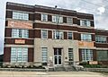
The Industrial Building.
-
A street in the Lauraville Historic District.
-
Homes in the Mayfield Historic District.
-
A street scene in the North Central Historic District.
-
The Null House.
-
Another view of the Old East Baltimore Historic District.
-
The Old Hamilton Library.
-
Public School No. 37.
-
Historic rowhouses on East North Avenue.
-
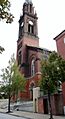
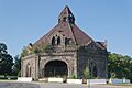
St. James the Less Roman Catholic Church.
-
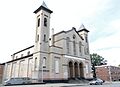
St. John the Evangelist Roman Catholic Church.
-
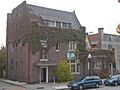
The Hans Schuler Studio and Residence.
-
Sydenham Hospital for Communicable Diseases.
-
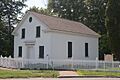
Taylor's Chapel.
-
A building in the Upper Fells Point Historic District.


