
National Register of Historic Places listings in Fergus County, Montana facts for kids

Welcome to Fergus County, Montana! This page is about special places in the county that are listed on the National Register of Historic Places. This is an official list in the United States that helps protect important buildings, sites, and objects. These places are special because they tell us about the history of Fergus County and the whole country.
When a place is on this list, it means it's recognized for its historical, architectural, or archaeological importance. It's like giving a medal to a building or a site for being a part of history! There are 45 such places in Fergus County. You can even see some of these places on a map if their exact location is shared.
Contents
Discovering Fergus County's Historic Gems
Fergus County is home to many fascinating historic places. These sites include old homes, schools, churches, and even entire neighborhoods! Each one has a unique story to tell about the people who lived and worked here long ago. Protecting these places helps us remember the past and learn from it.
Historic Homes and Buildings
Many of the listed places are old houses and important buildings in Lewistown, the county seat. These buildings show us how people lived and what kind of architecture was popular in the past.
- Anderson House (Lewistown): Added to the list in 1993.
- Ayers House (Lewistown): Recognized in 1986.
- Bright House (Lewistown): Became historic in 1993.
- Clark-Cardwell House (Lewistown): Listed in 1986.
- Culver Studio (Lewistown): This studio was added in 1980.
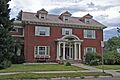
- Fergus County High School (Lewistown): This school building was listed in 1985. It's a place where many generations of students have learned.
- Fergus County Improvement Corporation Dormitory (Lewistown): Listed in 1980.
- Abraham and Mary Walton Hogeland House (Lewistown): This house was added in 2007.
- Huntoon Residence (Lewistown): Recognized in 1985.
- Lewis House (Lewistown): Became historic in 1993.
- Lewistown Mercantile Company (Lewistown): Listed in 1986.
- Mill House (Lewistown): This house, located southeast of Lewistown, was added in 1993.
- Schroeder Hospital (Lewistown): Listed in 1993.
- Stafford's Grocery (Winifred): This old grocery store was added in 2016.
- US Post Office and Federal Building-Lewistown (Lewistown): This important government building was listed in 1986.
_-_Fergus_County,_Montana.png)
Houses with Specific Addresses
Several houses are listed by their addresses, showing how many different homes have historical value:
- House at 301 Eighth Avenue, South (Lewistown): Listed in 1986.
- House at 324 W. Corcoran (Lewistown): Added in 1993.
- House at 618 West Janeaux (Lewistown): Recognized in 1986.
- House at 805 W. Watson (Lewistown): Became historic in 1993.
- House at 809 W. Watson (Lewistown): Listed in 1993.
- House at 813 W. Watson (Lewistown): Added in 1993.
Important Churches
Churches are often central to a community's history and architecture. Fergus County has several historic churches:
- First Presbyterian Church (Lewistown): This church was listed in 1986.
- St. James Episcopal Church and Parish House (Lewistown): Recognized in 1978.
- St. Joseph's Hospital (Lewistown): This hospital was added in 1978.
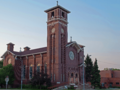
- St. Leo's Catholic Church (Lewistown): Listed in 1982.
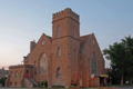
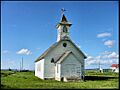
- St. Wenceslaus Catholic Church (Danvers): This church in Danvers was added to the list in 2014.
_-_Fergus_County,_Montana.png)
_-_Fergus_County,_Montana.png)
Historic Districts and Areas
Sometimes, not just one building, but a whole area or group of buildings is considered historic. These are called "historic districts."
- Judith Landing Historic District (Winifred): This district, partly in Chouteau County, was listed in 1975.
- Judith Place Historic District (Lewistown): Recognized in 1988.
- Lewistown Central Business Historic District (Lewistown): This area, the heart of Lewistown's business, was listed in 1985.
- Lewistown Courthouse Historic District (Lewistown): This district around the courthouse was added in 1985.
- Lewistown Satellite Airfield Historic District (Lewistown): Listed in 2000.
- Lewistown Silk Stocking District (Lewistown): This residential area was recognized in 1985.
- Naylor Brothers Ranch Historic District (Buffalo): This ranch district was added in 2008.


Other Notable Historic Sites
Beyond homes and districts, other unique places in Fergus County have made the historic register.
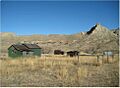
- Frank Hagadone Homestead (Winifred): This homestead, a historic farm or ranch, was listed in 2009.
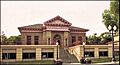
- Lewistown Carnegie Library (Lewistown): This library, built with money from Andrew Carnegie, was added in 1980. Carnegie libraries were built all over the country to help communities have access to books.
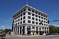
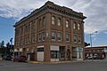
- Masonic Temple (Lewistown): This building, used by the Masonic fraternity, was listed in 1979.
- N-Bar Ranch (Grass Range): This historic ranch was recognized in 1991.
- Gus Nelson Homestead (Cow Island vicinity): This homestead along the Missouri River was added in 2011.
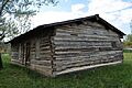
- Reed and Bowles Trading Post (Lewistown vicinity): This old trading post was listed in 2010. Trading posts were important places where people could trade goods and supplies.
- Reed's Fort Post Office (Lewistown): This historic post office was added in 2010.
- Fred Robinson Bridge (Lewistown vicinity): This bridge, an important part of transportation history, was listed in 2012. It also extends into Phillips County.
- Rocky Point (Landusky): This site in the Charles M. Russell National Wildlife Refuge was recognized in 1975.


These places help us understand the rich history of Fergus County, from early settlements and ranches to the growth of towns and important community buildings.
Images for kids
-

Fergus County High School in Lewistown.
-
The First Presbyterian Church in Lewistown.
-
The Frank Hagadone Homestead.
-
The Lewistown Carnegie Library.
-
A view of the Lewistown Central Business Historic District.
-

The Lewistown Courthouse Historic District.
-
A street view in the Lewistown Silk Stocking District.
-
The Masonic Temple in Lewistown.
-
St. Leo's Catholic Church in Lewistown.
-
St. Wenceslaus Catholic Church in Danvers.
-
The Reed and Bowles Trading Post.

