
National Register of Historic Places listings in Flagler County, Florida facts for kids

Hey there! Did you know that Flagler County, Florida, is home to some really cool and important historical places? These spots are so special that they've been added to the National Register of Historic Places. This is like a special list kept by the United States government to protect and celebrate buildings, sites, and objects that are important to our country's history.
There are 12 amazing places in Flagler County on this list. Each one tells a unique story about Florida's past, from old plantations to early roads and even a famous marine park! Let's explore some of these fascinating sites.
Contents
Discover Flagler County's Historic Treasures
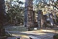
Bulow Plantation Ruins
Imagine a huge sugar plantation from the early 1800s! The Bulow Plantation Ruins are what's left of a large sugar mill and other buildings. This plantation was once a busy place, growing sugar cane, cotton, and indigo. Sadly, it was destroyed during the Second Seminole War in 1836. Today, you can visit the ruins and see the remains of the mill, a spring house, and a well. It's a great place to learn about Florida's plantation history and the challenges faced by early settlers. It was added to the National Register on September 29, 1970.
Cherokee Grove
The Cherokee Grove is a historic area located near Pellicer Creek. It's a beautiful natural spot that holds clues to the past. This area was once part of a large land grant and has been important for different groups of people throughout history. It's a quiet place where you can imagine what Florida looked like centuries ago. This site was recognized on May 2, 1997.
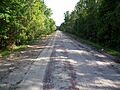
Dixie Highway - A Historic Road
Have you ever heard of the Dixie Highway? It was one of the earliest major highways in the United States, built in the early 1900s to connect the Midwest to the South. A section of this historic road, stretching from Espanola in Flagler County into St. Johns County, is on the National Register. This part of the road shows how people traveled long distances before modern highways like Interstate 95 existed. It's a reminder of how transportation has changed over time. This section was listed on April 20, 2005.
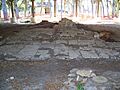
Mala Compra Plantation Archeological Site
The Mala Compra Plantation Archeological Site is another fascinating look into Florida's plantation past. This site is not about standing buildings, but about what lies beneath the ground! Archeologists study this area to uncover artifacts and learn about the lives of the people who lived and worked on this plantation. It helps us understand the daily routines and challenges of the past. This important site was added to the National Register on March 5, 2004.
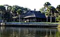
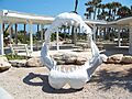
Marineland of Florida
Get ready for some marine history! Marineland of Florida, also known as Marine Studios, was one of the world's first oceanariums. Opened in 1938, it was originally designed as a huge underwater film studio where movies could be made with marine animals. Later, it became a popular tourist attraction, allowing people to see dolphins, whales, and other sea creatures up close. It played a big role in marine research and conservation. Marineland was listed on April 14, 1986.
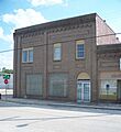
Old Bunnell State Bank Building
The Old Bunnell State Bank Building is a cool historic building right in Bunnell. Built in the early 20th century, this building shows the architectural style of its time and represents the growth of the town. Banks were very important for local businesses and families, and this building was a central part of Bunnell's community life for many years. It was added to the National Register on June 25, 1992.
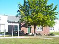
Vocational Agriculture Building
The Vocational Agriculture Building in Bunnell is another important historic structure. Built as part of the "New Deal" programs during the Great Depression, this building helped teach young people important skills in agriculture. It shows how communities worked to educate and support their citizens during tough economic times. This building was recognized on February 21, 2007.
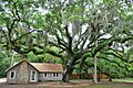
Washington Oaks Historic District
The Washington Oaks Historic District is part of the beautiful Washington Oaks Gardens State Park. This area includes historic elements of the park, which was once a private estate. It's known for its stunning gardens, ancient oaks, and a unique coquina rock formation along the ocean. The district tells the story of how people shaped the landscape and created a place of beauty and relaxation. It was added to the National Register on September 30, 2009.
Images for kids
-
Bulow Plantation Ruins
-
Cherokee Grove
-
Dixie Highway-Hastings, Espanola and Bunnell Road
-
Mala Compra Plantation Archeological Site
-
Marineland of Florida
-
Old Bunnell State Bank Building
-
Vocational Agriculture Building
-
Washington Oaks Historic District


