
National Register of Historic Places listings in Florence County, South Carolina facts for kids

Welcome to Florence County, South Carolina! This article is about special places in the county that are listed on the National Register of Historic Places. Think of this register as a very important list of buildings, sites, and objects across the United States that are worth saving because of their history. These places tell us stories about the past and help us understand how people lived long ago.
In Florence County, there are 29 places on this list. One of them is extra special and is called a National Historic Landmark. Let's explore some of these amazing historic spots!
Contents
What is the National Register of Historic Places?
The National Register of Historic Places is the official list of the nation's historic places that are considered worthy of preservation. It's like a hall of fame for buildings and sites! When a place is added to this list, it means it's important to the history of a community, a state, or even the whole country.
Being on the National Register helps protect these places. It also encourages people to learn about them and keep them safe for future generations. These sites can be anything from old houses and churches to entire neighborhoods or even battlefields.
Why are these places important?
These historic places are like time capsules. They show us how people lived, worked, and played in the past. They can teach us about different cultures, important events, and how our communities grew over time. By visiting or learning about these sites, you can connect with history in a real way.
Historic Places in Florence County
Florence County has many interesting places on the National Register. Let's look at a few examples that tell different parts of the county's story.
Browntown: A Glimpse into the Past
Browntown is a historic district near Johnsonville. It's a great example of a rural community from long ago. One of the notable features here is the Browntown Cotton Gin. Cotton gins were machines that separated cotton fibers from their seeds. They were very important in the South's history, especially for farming and the economy. This site helps us understand how agriculture shaped life in Florence County.
.jpg)
Florence National Cemetery: Honoring Heroes
The Florence National Cemetery is a special place where military veterans are buried. It's a quiet and respectful site that honors the men and women who served our country. National cemeteries are important reminders of the sacrifices made for freedom and peace. This cemetery in Florence is a place for reflection and remembrance.

Florence Downtown Historic District: City's Heartbeat
The Florence Downtown Historic District includes many old buildings in the heart of Florence city. These buildings show different styles of architecture from various time periods. Walking through this district is like taking a trip back in time, seeing how the city grew and changed. It includes parts of W. Evans, N. Dargan, and S. Dargan Streets.
Mt. Zion Rosenwald School: Education for All
The Mt. Zion Rosenwald School is a significant site because it represents an important part of education history. Rosenwald Schools were built in the early 20th century to provide better education for African American children in the rural South. These schools were funded by Julius Rosenwald, who was the president of Sears, Roebuck and Company, along with local communities. This school shows a time when communities worked together to improve education for everyone.
Snow's Island: A National Historic Landmark
Snow's Island is a very important place, so important that it's a National Historic Landmark! This means it has exceptional national historical significance. Snow's Island is located along the Pee Dee River, east of Johnsonville. During the American Revolutionary War, it was a secret camp and base for General Francis Marion, also known as the "Swamp Fox." He used the island's swampy terrain to hide from British forces and launch surprise attacks. This site is a powerful reminder of the bravery and cleverness of those who fought for America's independence.
Slave Houses, Gregg Plantation: A Difficult Past
The Slave Houses at Gregg Plantation are located on the campus of Francis Marion University. These structures are a somber reminder of the difficult history of slavery in the United States. They help us understand the lives of enslaved people and the challenges they faced. Preserving these sites is important for remembering and learning from all parts of our history.
Other Notable Listings
Many other places in Florence County are also on the National Register. These include:
- W.T. Askins House in Lake City.
- Blooming Grove in Florence.
- Bonnie Shade in Florence.
- Christ Episcopal Church in Florence.
- Claussen House in Florence.
- Florence Public Library in Florence.
- Gregg-Wallace Farm Tenant House in Mars Bluff.
- Hopewell Presbyterian Church and Hopewell Cemetery in Florence.
- Lake City Downtown Historic District in Lake City.
- Poynor Junior High School in Florence.
- Rankin-Harwell House in Florence.
- Red Doe in Florence.
- Roseville Plantation in Florence.
- Smith-Cannon House in Timmonsville.
- U.S. Post Office in Florence.
- Young Farm in Florence.
These places, whether they are homes, churches, or public buildings, all contribute to the rich history of Florence County. They are important parts of our shared heritage.
Images for kids
-
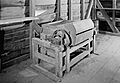
The historic Browntown Cotton Gin.
-
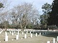
A view of the Florence National Cemetery.
-
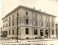
The U.S. Post Office in Florence, South Carolina, in 1938.
_1938.jpg)
