
National Register of Historic Places listings in Franklin County, Kentucky facts for kids

Welcome to Franklin County, Kentucky! This page is all about special places in the county that are listed on the National Register of Historic Places. Think of this register as a very important list of buildings, sites, and objects that are worth saving because of their history, architecture, or what they mean to our country.
In Franklin County, there are 56 places on this list. Three of them are even more special and are called National Historic Landmarks. These landmarks are recognized as being important to the entire United States! You can see where some of these places are on a map if their exact location is shared.
Contents
Historic Buildings and Homes
Franklin County is home to many old and beautiful buildings. These places tell us stories about the past.
Important Houses
- Col. R.T.P. Allen House: This historic home is located south of Frankfort. It was added to the list in 1979.
- Beeches: Another historic house in Frankfort, added in 1979.
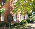
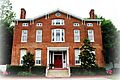
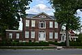
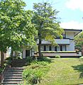
- George F. Berry House: Found at 700 Louisville Road in Frankfort, this house was listed in 2002.
- Blanton-Crutcher Farm: This farm, located southeast of Frankfort, has been on the register since 1975.
- Brown-Henry House: An interesting home at 818 Fields Avenue in Frankfort, added in 2014.
- Giltner-Holt House: This house is about 5 miles north of Frankfort and was listed in 1978.
- Glen Willis: Located on Leestown Pike in Frankfort, this site was recognized in 1972.
- Gooch House: You can find this house at 104 2nd Street in Frankfort. It became a historic place in 1980.
- Knight-Taylor-Hockensmith House: This house is at 4350 Peaks Mill Road in Frankfort, added in 2013.
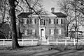
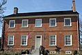
- Charles S. Morehead House: This was the home of Governor Charles S. Morehead, located at 217 Shelby Street in Frankfort. It was listed in 1974.
- Old Governor's Mansion: Located at 420 High Street in Frankfort, this was an earlier home for Kentucky's governors. It was added to the register in 1971.
- Charles Patterson House: This house is on KY 1689 in Frankfort and was listed in 1983.
- Penn-Marshall Stone House: East of Harvieland, this stone house near the Kentucky River was listed in 1975.
- Point Breeze: Found at 219 Riverview Street in Frankfort, this property was added in 2014.
- Scotland: About 5 miles east of Frankfort on Versailles Road, this historic site was listed in 1976.
- Robert Todd Summer Home: Located on U.S. Route 421 in Frankfort, this summer home was added in 1983.
- Andrew Trumbo Log House: East of Frankfort on Glenns Creek Road, this log house was listed in 1977.
- Weehawken: This historic place is at 1 Weehawken Lane in Jett, listed in 2007.
- Jesse R. Zeigler House: Located at 509 Shelby Street in Frankfort, this house was added in 1976.
Government and Public Buildings
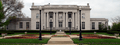
- Kentucky Governor's Mansion: This beautiful mansion is the official home of Kentucky's governor. It's on the Capitol grounds in Frankfort and was listed in 1972.
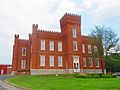
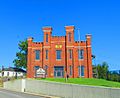
- Kentucky State Arsenal: An important building for storing weapons and supplies, located on Main Street at Capital Avenue in Frankfort. It was listed in 1973.
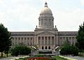
- Kentucky State Capitol: The main building where Kentucky's laws are made. It's a grand building on the Capitol grounds in Frankfort, listed in 1973.
- Old United States Courthouse and Post Office: This historic building at 305 Wapping Street in Frankfort served as a courthouse and post office. It was listed in 1974.
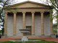
- Old State Capitol: This building, on Broadway in Frankfort, was Kentucky's state capitol before the current one was built. It's a National Historic Landmark, recognized in 1971.
Schools and Institutions
- Bridgeport School: This old school building at 555 Bridgeport Road in Bridgeport was listed in 2014.
- E.E. Hume Hall: Located on the Kentucky State University campus in Frankfort, this hall was added to the register in 1983.
- Jackson Hall, Kentucky State University: Another important building on the Kentucky State University campus in Frankfort, listed in 1973.
- Stewart Home School: This school, about 5.5 miles south of Frankfort, has been on the register since 1976.
Historic Districts and Sites
Some areas have many historic buildings close together, forming a "historic district." Other sites are important for different reasons, like ancient history or monuments.
Historic Districts
- Central Frankfort Historic District: This large area in Frankfort includes many historic buildings and streets, bounded by different roads and the Kentucky River. It was listed in 2009.
- Corner in Celebrities Historic District: This district in Frankfort is roughly bounded by the Kentucky River, St. Clair, and Main Streets. It was recognized in 1971.
- Frankfort Barracks District: This area in Frankfort, bounded by New, Shelby, and Coke Streets, and Woodland Avenue, was listed in 1975.
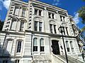
- Frankfort Commercial Historic District: This district includes both sides of the Kentucky River at Bridge Street in Frankfort, important for its business history. It was listed in 1979.
- Old Statehouse Historic District: This area around the Old State Capitol in Frankfort is also a historic district, listed in 1980.
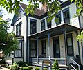
- South Frankfort Neighborhood Historic District: This neighborhood in Frankfort, roughly bounded by U.S. Route 60, Rockland Court, and the Kentucky River, was listed in 1982.
Archaeological Sites
Several sites in Franklin County are important for their archaeological findings, meaning they contain clues about ancient human life. These locations are often kept secret to protect them.
- Archeological Site 15 Fr 26: Near Harvieland, listed in 1978.
- Archeological Site 15 Fr 34: In Frankfort, listed in 1978.
- Archeological Site 15 Fr 52: Near Harvieland, listed in 1978.
- Archeological Site 15 FR 368 (Fort Hill): This site in Frankfort is a Civil War fort, listed in 1985.
- Dills Site: In Frankfort, listed in 1978.
- Hutcherson Site: In Polsgrove, listed in 1978.
- Risk Brothers Site: In Frankfort, listed in 1978.
- Valley Farm Ruins: In Frankfort, listed in 1975.
Other Notable Sites
- Arrowhead: Located on U.S. Route 60 south of Hanley Lane in Frankfort, this site was listed in 1989.
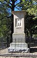
- Colored Soldiers Monument in Frankfort: This monument honors African American soldiers and is located in Greenhill Cemetery in Frankfort. It was listed in 1997.
- Confederate Monument in Frankfort: This monument is at 215 East Main Street in Frankfort and was listed in 1997.
- Frankfort Cemetery: This historic cemetery at 215 East Main Street in Frankfort, including its chapel, was listed in 1974. It is the burial place of many important Kentuckians, including Daniel Boone.
- Frankfort Greenhouses: These greenhouses at 210, 212, and 216 East Main Street in Frankfort were listed in 1997.
- Frankfort Storage Building-Armory: This building at 208 Maryland Avenue in Frankfort was listed in 2002.
- Haggin Farm: Located on KY 1685 near Midway, this farm was listed in 1983.
- Andrew Hearn Log House and Farm: About 3 miles southwest of Jett, this log house and farm were listed in 1976.
- Julian Farm: On the southern side of U.S. Route 60 in Bridgeport, this farm was listed in 1988.
- Liberty Hall: Located at 218 Wilkinson Street in Frankfort, this is a National Historic Landmark, recognized in 1971. It's a very important historic home.
- Old Stone Tavern: Found at Scruggs Lane and Leestown Pike in Frankfort, this old tavern was listed in 1983.
- George T. Stagg Distillery: Located at 1001 Wilkinson Boulevard in Frankfort, this distillery is a National Historic Landmark, recognized in 2001. It's known for its historic buildings related to making spirits.
- Switzer Covered Bridge: This beautiful old covered bridge crosses North Elkhorn Creek off Rocky Branch Road in Switzer. It was listed in 1974.
Images for kids
-
The George F. Berry House in Frankfort.
-
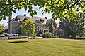
A view of the Old Statehouse Historic District.
-
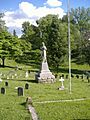
The Colored Soldiers Monument in Frankfort.
-
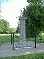
The Confederate Monument in Frankfort.
-
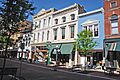
A scene from the Corner in Celebrities Historic District.
-
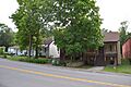
Shelby Street in the Frankfort Barracks District.
-
The grave of Daniel and Rebecca Boone in Frankfort Cemetery.
-
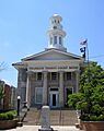
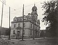
The Franklin County Courthouse, part of the Frankfort Commercial Historic District.
-
Glen Willis, a historic home in Frankfort.
-
The Gooch House, also serving as a Visitor Center.
-
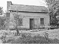
The Andrew Hearn Log House and Farm.
-
Jackson Hall at Kentucky State University.
-
The Kentucky Governor's Mansion.
-
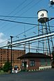
The Kentucky State Arsenal.
-
The Kentucky State Capitol building.
-
Liberty Hall in Frankfort.
-
The Charles S. Morehead House.
-
The Old Kentucky Governor's Mansion.
-
The Old State Capitol of Kentucky.
-
The Old Capitol Annex in Frankfort.
-
The Old U.S. Courthouse and Post Office.
-
The George T. Stagg Distillery.
-
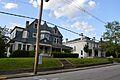
A street view in the South Frankfort Neighborhood Historic District.
-
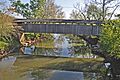
The Switzer Covered Bridge.
-
The Jesse R. Zeigler House.


.jpg)


