
National Register of Historic Places listings in Gadsden County, Florida facts for kids

Welcome to Gadsden County, Florida! This special place is home to many historic buildings and sites. These aren't just any old buildings; they are listed on the National Register of Historic Places. This is an official list kept by the United States government. When a place is on this list, it means it's important to the history of the country, the state of Florida, or even just Gadsden County.
These historic places help us learn about the past. They show us how people lived, worked, and built things many years ago. In Gadsden County, there are 18 properties and areas that are part of this important list. Let's explore some of them!
Contents
Historic Buildings in Gadsden County
Gadsden County has many fascinating old buildings. Each one tells a story about the past.
Homes with History
Many of the places on the National Register are old homes. Imagine living in a house that's been around for over a hundred years!
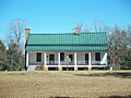
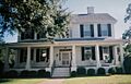
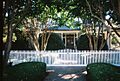
Joshua Davis House
The Joshua Davis House is a beautiful old home located near Mount Pleasant. It was added to the National Register in 1975. This house gives us a peek into what homes looked like in the past.

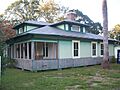
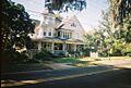
Dezell House
In Greensboro, you can find the Dezell House at 328 East 8th Street. This house became a historic listing in 2006. It's a great example of the architecture from its time.

Willoughby Gregory House
The Willoughby Gregory House is in Quincy, at the corner of Highway 274 and Krausland Road. It joined the National Register in 1983. This house has stood for many years, watching history unfold around it.

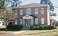
E. C. Love House
Also in Quincy, the E. C. Love House is located on North Jackson Street. It was listed in 1974. This house is a reminder of the people who shaped Quincy's early days.

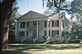
John Lee McFarlin House
Another historic home in Quincy is the John Lee McFarlin House on East King Street. It was added to the list in 1974. These old homes help us understand how families lived long ago.

Dr. Malcolm Nicholson Farmhouse
Near Havana, you'll find the Dr. Malcolm Nicholson Farmhouse. It's on the north side of State Road 12. This farmhouse became a historic site in 1994. It shows us what farm life was like in the area.

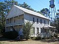
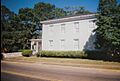
E. B. Shelfer House
The E. B. Shelfer House is another historic home in Quincy, on North Madison Street. It was listed in 1975. Many of these old houses are still standing and cared for today.

Stockton-Curry House
Also in Quincy, the Stockton-Curry House is on North Duval Street. It joined the National Register in 1974. These homes are like living museums, showing us the past.

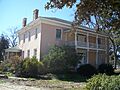
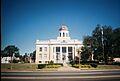
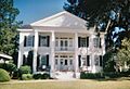
Judge P. W. White House
The Judge P. W. White House is in Quincy on North Madison Street. It was one of the first Gadsden County sites listed, back in 1972. It's a great example of older architecture.

Important Public Buildings and Areas
Not just homes, but also schools, churches, and even whole neighborhoods can be historic.
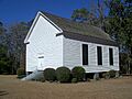
Gretna School
The Gretna School on Church Street in Gretna is a historic building. It was added to the list in 2008. Old schools like this remind us how education has changed over time.

Old Philadelphia Presbyterian Church
Five miles north of Quincy, off State Road 65, stands the Old Philadelphia Presbyterian Church. This church became a historic site in 1975. Churches often play a big role in a community's history.

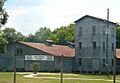
Planter's Exchange, Inc.
In Havana, the Planter's Exchange, Inc. building on Second Street Northwest is a historic spot. It was listed in 1999. This building likely played a part in the local economy many years ago.

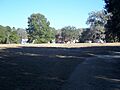
Quincy Historic District
The Quincy Historic District is not just one building, but a whole area in Quincy! It's roughly bounded by Sharon, Clark, Stewart, and Corry Streets. This district was added to the National Register in 1978. It means that many buildings in this area are important together, showing how a town grew.

Quincy Library
The Quincy Library on North Adams Street is another important building in Quincy. It was listed in 1974. Libraries are often central to a community's learning and history.

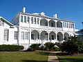
Quincy Woman's Club
The Quincy Woman's Club on North Calhoun Street became a historic site in 1975. Clubs like this often played a big role in social life and community improvements.

U.S. Arsenal-Officers Quarters
In Chattahoochee, within the Florida State Hospital grounds, you can find the U.S. Arsenal-Officers Quarters. This site was listed in 1973. An "arsenal" is a place where weapons or military supplies are made or stored. These quarters were where officers lived, showing a military past for the area.

Former Listings
Sometimes, a historic place might be removed from the National Register. This can happen if the building is changed too much, or if it is unfortunately destroyed.
Malachi Martin House
The Malachi Martin House near Chattahoochee was once on the list, added in 1976. However, it was removed in 1989. Even if a place is no longer on the list, it can still be a part of local history.
Images for kids
-
The historic Joshua Davis House.
-
The Dezell House in Greensboro.
-
The Willoughby Gregory House.
-
The historic Gretna School.
-
The E. C. Love House.
-
The John Lee McFarlin House.
-
The Dr. Malcolm Nicholson Farmhouse.
-
The Old Philadelphia Presbyterian Church.
-
The Planter's Exchange, Inc. building.
-
A building within the Quincy Historic District.
-
The historic Quincy Library.
-
The Quincy Woman's Club.
-
The E. B. Shelfer House.
-
The Stockton-Curry House.
-
The U.S. Arsenal-Officers Quarters.
-
The Judge P. W. White House.
