
National Register of Historic Places listings in Grant County, New Mexico facts for kids

Welcome to Grant County, New Mexico! This area is home to many amazing places that are super important to American history. These special spots are listed on something called the National Register of Historic Places. Think of it like a Hall of Fame for historic buildings, sites, and objects across the United States.
In Grant County, there are 45 different properties and areas that have made it onto this important list. One of them is even a National Historic Landmark, which is an extra special title! All these places are also recognized by the New Mexico State Register of Cultural Properties, meaning they're important to both the state and the whole country. Let's explore some of these cool historic places!
Contents
What is the National Register of Historic Places?
The National Register of Historic Places is the official list of places in the United States that are worth saving. It includes buildings, structures, objects, sites, and districts. These places are chosen because they tell important stories about American history, architecture, archaeology, engineering, or culture.
Why are these places important?
When a place is added to the National Register, it means it's recognized for its historical value. This helps protect it and makes people aware of its importance. It also helps make sure these places can be enjoyed and learned from by future generations. It's like a big scrapbook of America's past, and Grant County has many pages in it!
Historic Places in Grant County
Grant County is full of history, from old homes and schools to important military sites. Here are a few examples of the cool places you can find on the National Register in this area.
Fort Bayard Historic District

One of the most important places in Grant County is the Fort Bayard Historic District. This site is so special that it's been named a National Historic Landmark! Fort Bayard was originally a military fort built in 1866. It played a big role in the Apache Wars. Later, it became a hospital for soldiers, especially those with tuberculosis. Today, it's a reminder of military history and medical care in the past. You can find it north of the junction of U.S. Route 180 and State Road 152.
Silver City Historic District

The heart of Silver City is its historic district, which is also on the National Register. This area is roughly bounded by Black, College, Hudson, and Spring Streets. Walking through this district is like stepping back in time! You can see many old buildings that show what the town looked like long ago. These buildings tell the story of Silver City's past, from its mining days to its growth as a community. A part of this district was even expanded in 2013 to include more historic spots.
Chihuahua Hill Historic District

Another interesting area in Silver City is the Chihuahua Hill Historic District. This neighborhood is bounded by Cooper, Spring, Bullard, and Chihuahua Streets. It's known for its unique architecture and its history as a vibrant community. Many of the homes and buildings here have a distinct style that reflects the people who lived and worked there. It's a great place to see how different parts of Silver City grew over time.
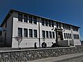
Western New Mexico University Buildings
Several buildings on the campus of Western New Mexico University (WNMU) in Silver City are also historic. These include:
- Bowden Hall: Located northeast of Light Hall, this building is an important part of the university's history.
- Fleming Hall: Found on 10th Street, northeast of Bowden Hall, Fleming Hall has been a key part of the campus for many years.
- Graham Gymnasium: On Florida Street, this gym has seen many student activities and sports events over the years.
- Heating Plant: Also on 10th Street, this building was essential for keeping the university warm.
- Light Hall: On the northern side of College Avenue, Light Hall is a central building on the WNMU campus.
- Ritch Hall: Southeast of Fleming Hall on 10th Street, Ritch Hall also contributes to the historic feel of the university.
These buildings show the growth and development of education in Grant County.
Other Notable Historic Places
Grant County has many other individual buildings and sites that are important. Here are just a few:
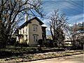
- H. B. Ailman House: This historic house at 314 W. Broadway in Silver City gives us a peek into how people lived in the past.
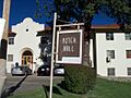
- Bullard Hotel: Located at 102 S. Bullard Street in Silver City, this old hotel tells stories of travelers and visitors from long ago.
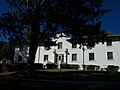
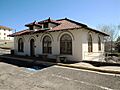
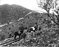
- L.C. Ranch Headquarters: Found off U.S. Route 260 in Gila, this ranch headquarters is a reminder of the area's ranching history.
- Pinos Altos Historic District: In the town of Pinos Altos, this district includes Gold Avenue and Cherry, Main, Church, and Silver Streets. It shows the history of this old mining town.
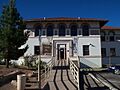
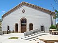
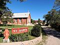
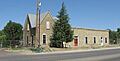
- St. Mary's Academy Historic District: At 1813 N. Alabama Street in Silver City, this district highlights the history of education and religious institutions in the area.
- Silver City Water Works Building: On Little Walnut Road in Silver City, this building was important for providing water to the town.
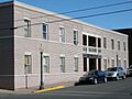
- Silver City Woman's Club: Located at 411 Silver Heights Boulevard, this club building shows the history of women's groups and community efforts.
- San Lorenzo Historic District: This district, roughly Galaz Street between C and H Streets, preserves the history of the community of San Lorenzo.
- Reeds Peak Lookout Tower: Found at Squeaky Spring in the Gila National Forest, this tower was used to spot wildfires and is an interesting piece of forest service history.
These are just some of the many places in Grant County that are recognized for their historical importance. Each one has a unique story to tell about the past!
Images for kids
-
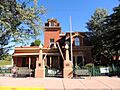
The H.B. Ailman House in Silver City.
-
Bowden Hall at Western New Mexico University.
-
The historic Bullard Hotel.
-

Some historic sites have restricted addresses for protection.
-
Fleming Hall on the WNMU campus.
-
Graham Gymnasium at WNMU.
-
The Heating Plant at WNMU.
-
The L.C. Ranch Headquarters.
-
Light Hall at WNMU.
-
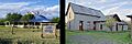
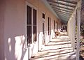
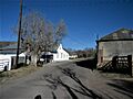
Historic houses in the Mimbres area.
-
A historic building in Pinos Altos.
-
Ritch Hall at WNMU.
-
St. Mary's Academy in Silver City.
-
The San Lorenzo Historic District.
-
A building in the Silver City North Addition Historic District.
-
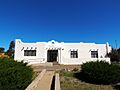
The Silver City Water Works Building.
-
The Silver City Woman's Club building.


