
National Register of Historic Places listings in Grant County, South Dakota facts for kids

Have you ever wondered about the old buildings and places in your town? Some of them are so special that they are put on a list called the National Register of Historic Places! This list is like a hall of fame for important buildings, sites, and objects across the United States. When a place is added to this list, it means it has a unique story to tell about our history, architecture, or culture.
In Grant County, South Dakota, there are 15 amazing places that have earned a spot on this special list. These historic treasures help us understand what life was like long ago and make sure these important parts of our past are protected for everyone to enjoy and learn from in the future. You can even see where some of these places are on a map!
Contents
Discovering Grant County's Historic Places
Grant County is home to many fascinating historic sites, from old churches and banks to unique homes and farm buildings. Each one tells a piece of the county's story. Let's explore some of these special places!
Important Buildings in Big Stone City
Big Stone City has a few buildings that are recognized for their history.
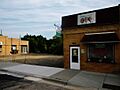
Big Stone City Hall
The Big Stone City Hall is a significant building located right on Main Street. It was added to the National Register in 2004. City halls are often important because they are where local government decisions are made, and they can be beautiful examples of older architecture.
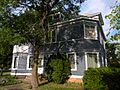
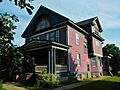
James A. and Ida Bell Gold House
The James A. and Ida Bell Gold House is another historic spot in Big Stone City. This house, built long ago, was added to the list in 2008. Old homes like this can show us how people lived and what styles were popular in the past.
Historic Spots in Milbank
Milbank, the county seat of Grant County, has several buildings that are part of the National Register.
First Congregational Church of Milbank
The First Congregational Church of Milbank was recognized in 1978. Churches are often central to a community's history, serving as places of worship and gathering for many years.
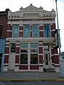
First National Bank of Milbank
Also listed in 1978, the First National Bank of Milbank building on South Main Street is a reminder of the county's economic past. Banks played a huge role in the growth of towns and cities.
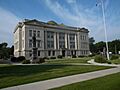
Grant County Courthouse
The Grant County Courthouse is a very important building, listed in 1993. Courthouses are usually grand buildings where legal matters are handled and local government operates. They often stand as symbols of a county's identity.
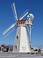
Hollands Grist Mill
The Hollands Grist Mill, located near U.S. Route 12, was added to the list in 1981. Grist mills were essential in the past for grinding grain into flour, helping feed communities. This mill shows us how people used to process food.
Emil and Hannah Johnson House
The Emil and Hannah Johnson House in Milbank was recognized in 2008. Like the Gold House, it offers a glimpse into the residential architecture and family life of earlier times.
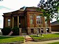
Milbank Carnegie Library
The Milbank Carnegie Library joined the National Register in 1978. Carnegie libraries were built all over the United States with money from Andrew Carnegie, a famous businessman. These libraries were incredibly important for providing education and books to communities.
Other Notable Historic Places
Grant County's historic sites are spread across different towns and rural areas.
Brown Earth Presbyterian Church
Northeast of Stockholm, the Brown Earth Presbyterian Church was listed in 1984. This church is a significant part of the history of the Stockholm area.
First State Bank Building in Revillo
The First State Bank Building on Main Street in Revillo was added to the list in 1987. This building represents the early financial history of the town of Revillo.
Herman Friewald Barn
Near Big Stone City, the Herman Friewald Barn was recognized in 2008. Barns and farm buildings are crucial for understanding the agricultural history of a region, showing how farming was done in the past.
George and Mary Koch Farm
The George and Mary Koch Farm near Twin Brooks was listed in 2008. This farm is important because it shows how farms were set up and operated, giving us clues about rural life and farming practices.
Lebanon Lutheran Church
About eight miles southwest of Summit, the Lebanon Lutheran Church was added to the National Register in 1977. This church served as a spiritual and community center for people living in the rural areas around Summit.
Ole Nelson Barn
Another historic barn, the Ole Nelson Barn, is located near Summit and was recognized in 2008. It's another great example of the agricultural heritage of Grant County.
Swedish Lutheran Church of Strandburg
The Swedish Lutheran Church of Strandburg on Main Street was listed in 1978. Many early settlers in South Dakota came from Scandinavian countries like Sweden, and their churches are important cultural landmarks.
Images for kids
-
Big Stone City Hall
-

First Congregational Church of Milbank
-
First National Bank of Milbank
-
James A. and Ida Bell Gold House
-
Grant County Courthouse
-
Hollands Grist Mill
-
Emil and Hannah Johnson House
-
Milbank Carnegie Library


