
National Register of Historic Places listings in Greene County, Georgia facts for kids

Greene County, Georgia, is home to many special places that are listed on the National Register of Historic Places (NRHP). This list includes buildings, homes, and even entire neighborhoods that are important because of their history. These places help us remember the past and understand how people lived long ago in Greene County.
Contents
What is the National Register of Historic Places?
The National Register of Historic Places is like a special list kept by the United States government. It names buildings, sites, objects, and districts that are important in American history, architecture, archaeology, engineering, or culture. When a place is added to this list, it means it is recognized as a valuable part of our country's heritage. It also helps protect these places for future generations.
Historic Places in Greene County
Greene County has many fascinating places on the National Register. These sites tell stories about the people and events that shaped this area. From old churches to grand homes and busy town centers, each place has a unique history to share.
Important Buildings and Homes
Many individual buildings in Greene County have been recognized for their historical value. These include places where people lived, worshipped, or gathered.
Bethesda Baptist Church and Cemetery
The Bethesda Baptist Church and its cemetery are located near Union Point. This site was added to the National Register in 1998. It is an important example of early religious life in the county. The church and its burial ground show us how communities grew around their places of worship.
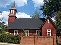
Church of the Redeemer
In Greensboro, you can find the Church of the Redeemer. This beautiful church was listed in 1987. It stands at the corner of Main and North Streets. The church's design and history reflect the architecture and community spirit of its time.
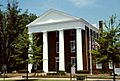
Greene County Courthouse
The Greene County Courthouse, located in Greensboro, is a very important building. It was added to the National Register in 1980. Courthouses are often the center of a county's government and community life. This building has seen many important decisions and events over the years.
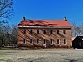
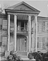
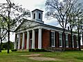
Jefferson Hall
Jefferson Hall is a historic home located in Union Point. It was listed in 1989. This grand building gives us a glimpse into the past. It shows the style of homes built in the area many years ago.
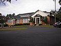
Siloam Junior High School
The old Siloam Junior High School in Siloam is also on the list, added in 2002. Schools are vital parts of any community's history. This building reminds us of how education has changed and grown in Greene County.
Special Historic Areas
Sometimes, an entire area or neighborhood is considered historically important. These are called historic districts. They often include many buildings that together tell a bigger story.
Penfield Historic District
The Penfield Historic District, north of Greensboro, was recognized in 1976. Penfield was once a very important town. It was home to Mercer University in its early years. This district preserves the look and feel of a historic Georgia town.
Siloam Historic District
The town of Siloam also has its own historic district, listed in 2001. This district includes many buildings centered around Main Street, Union Point Highway, and Church Street. It shows the development of a small town in rural Georgia.
Greensboro Historic Districts
Greensboro has several historic districts that are on the National Register. These include the Greensboro Commercial Historic District, the North Street-East Street Historic District, and the South Street-Broad Street-Main Street-Laurel Street Historic District. These areas show how the town grew and changed over time. They include old shops, homes, and public spaces that tell the story of Greensboro's past.
Why are these places important?
These historic places are important for many reasons. They help us learn about the past, understand different architectural styles, and appreciate the lives of people who came before us. Protecting these sites means we can keep their stories alive and share them with future generations. They are like open-air museums that teach us about our heritage.
Images for kids
-
Bethesda Baptist Church
-
Church of the Redeemer
-
Greene County Courthouse
-
Jefferson Hall
-
Mercer Chapel in the Penfield Historic District
-
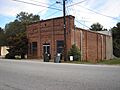
A building in the Siloam Historic District
-
Siloam Junior High School


