
National Register of Historic Places listings in Guadalupe County, Texas facts for kids

Guadalupe County, Texas, is home to many amazing places that are important to history! These special spots are listed on the National Register of Historic Places. This list helps protect buildings, structures, and areas that tell us about the past. It's like a hall of fame for historic sites across the United States.
Contents
What is the National Register of Historic Places?
The National Register of Historic Places is an official list kept by the United States government. It includes places that are important because of their history, architecture, or what they represent. When a place is on this list, it means it's recognized as a valuable part of our country's story. This helps people understand and protect these sites for future generations.
Why are these places important?
These historic places help us learn about how people lived long ago. They show us different styles of buildings, how towns grew, and what kind of work people did. Visiting these sites can feel like stepping back in time! They are like giant history books you can walk through.
Historic Homes and Buildings in Guadalupe County
Many of the historic places in Guadalupe County are old homes and important buildings. These structures often show unique building styles from different time periods.
Famous Houses
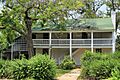
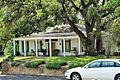
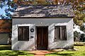
Several houses in Seguin and nearby areas are on the list. For example, the Erskine House No. 1 and the Robert Hall House in Seguin are recognized for their history. The Joseph F. Johnson House is another beautiful old home. These houses give us a peek into the lives of early residents.
The Sebastopol House State Historic Site in Seguin is very special. It was built in the 1850s using a unique concrete method. This makes it one of the earliest concrete buildings in Texas! It's now a museum where you can learn about its past.
Near Kingsbury, you can find the Dublin Plantation. This historic property reminds us of the large farms that were once common in this area. Another interesting home is the Edward and Texanna Tewes House, which tells a story of a family's life in the county.
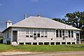
Other Important Structures
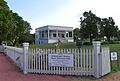
The Park Hotel in Seguin is another historic building. Hotels were once central gathering places for travelers and locals. This hotel shows us what life was like when people traveled by horse and buggy or early cars.
The Sweet Home Vocational and Agricultural High School is also on the list. This school played a big role in educating young people in the area. It taught them important skills for farming and other trades.
Unique Historic Sites
Not all historic places are buildings. Some are structures or even entire areas that have historical value.
Saffold Dam
The Saffold Dam near Seguin is a cool example of a historic structure. Dams are built to control water flow, and this one has been important to the local community for a long time. It shows how people used engineering to manage natural resources.
Historic Districts
Sometimes, a whole area or group of buildings is considered historic. The Seguin Commercial Historic District is one such place. This district includes many buildings in downtown Seguin that were built between 1875 and 1949. Walking through it, you can imagine what the town looked like many years ago, with shops and businesses bustling with activity.
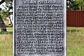
Another interesting site is the Wilson Utility Pottery Kilns Archeological District. This area, near Capote, holds the remains of old pottery kilns. It tells us about the early industries and crafts in Guadalupe County. Archeological sites like this help us understand how people made things and lived in the past.
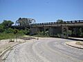
Historic Bridges
Bridges can also be historic! The State Highway 3-A Bridge at Cibolo Creek is an example. This bridge, located at the county line, is important because of its design and how it helped connect different areas. Bridges are vital parts of transportation history.
These historic places in Guadalupe County are like treasures. They help us connect with the past and understand the rich history of Texas.
Images for kids
-
Erskine House No. 1
-
Robert Hall House
-

Joseph F. Johnson House
-
Los Nogales
-

Park Hotel
-

Saffold Dam
-
Sebastopol House State Historic Site
-

Seguin Commercial Historic District
-
State Highway 3-A Bridge at Cibolo Creek
-
Sweet Home Vocational and Agricultural High School
-

Edward and Texanna Tewes House
-
Wilson Utility Pottery Kilns Archeological District historical marker


