
National Register of Historic Places listings in Hall County, Nebraska facts for kids

Hall County, Nebraska, is home to many special places that are listed on the National Register of Historic Places. This is an official list kept by the United States government. It helps to protect buildings, sites, and objects that are important to American history, architecture, archaeology, engineering, or culture. When a place is on this list, it means it's recognized for its unique value and efforts are made to preserve it for future generations.
In Hall County, there are 28 different properties and areas that have earned a spot on this important list. These places tell stories about the people who lived here, the buildings they built, and the events that shaped the area. Let's explore some of these fascinating historic sites!
Historic Buildings and Homes
Many of the places on the National Register in Hall County are old buildings, including beautiful homes, churches, and public buildings. These structures often show us how people lived and worked in the past.
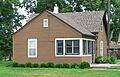
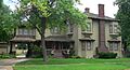
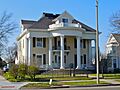
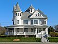
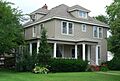
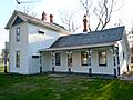
H.J. Bartenbach House
The H.J. Bartenbach House is a historic home located in Grand Island. It was built a long time ago and is recognized for its special design and history. It's a great example of the kind of homes people built in the late 1800s.
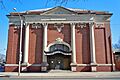
Cathedral of the Nativity of the Blessed Virgin Mary
This beautiful church in Grand Island is also on the list. Cathedrals are usually very large and important churches, and this one has been a significant landmark in the community for many years. Its architecture is quite impressive.
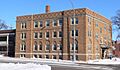
Grand Island Carnegie Library
Libraries are places where people can learn and read, and the Grand Island Carnegie Library has a special history. It was built with money donated by Andrew Carnegie, a famous businessman who helped fund many libraries across the country. This building has served as a center for learning and community gatherings for a very long time.
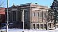
Hall County Courthouse
The Hall County Courthouse in Grand Island is where many important government decisions for the county are made. Courthouses are often grand buildings that show the importance of law and order in a community. This one has stood for many years, witnessing much of Hall County's history.
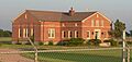
The Hotel Yancey
The Hotel Yancey in Grand Island was once a busy place where travelers and visitors would stay. Hotels like this were important hubs for social life and business in the past. It tells a story about how people traveled and interacted in earlier times.
Important Sites and Structures
Beyond buildings, the National Register also includes other types of historic sites, like old roads, bridges, and even places where important events happened.
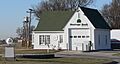
Burlington Railroad Depot
The Burlington Railroad Depot in Grand Island was a train station. Train depots were once very busy places, as trains were a main way for people and goods to travel across the country. This depot played a big role in connecting Grand Island to other places.
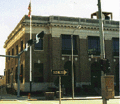
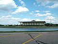
Grand Island FCC Monitoring Station
This site in Grand Island is a bit different! The FCC Monitoring Station was used by the government to listen to radio signals. It played a part in making sure radio communications were clear and safe, which was very important for national security and communication.
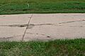
Lincoln Highway-Grand Island Seedling Mile
The Lincoln Highway was one of the first transcontinental highways in the United States, meaning it stretched all the way across the country. The "Seedling Mile" in Grand Island is a special section of this old road. It shows how early roads were built and how they helped people travel long distances by car.
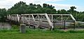
Nine Bridges Bridge
Near Doniphan, the Nine Bridges Bridge is an interesting piece of engineering. Bridges are vital for connecting places, and this one has a unique design or history that makes it special enough to be on the National Register. It crosses the Middle Channel of the Platte River.
Stolley Homestead Site
The Stolley Homestead Site in Grand Island is a place where early settlers, like the Stolley family, built their homes and started new lives. Homesteads are important because they show us how pioneers lived and worked the land when Nebraska was first being settled.
Stuhr Museum of the Prairie Pioneer
The Stuhr Museum is a place dedicated to preserving and sharing the history of pioneers who settled the prairie. It's not just one building, but a whole museum complex that helps people understand what life was like for early settlers in Nebraska. It's a living history museum where you can see how things were done in the past.
Images for kids
-

The H.J. Bartenbach House.
-
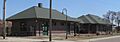
The Burlington Railroad Depot.
-
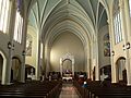
Inside the Cathedral of the Nativity of the Blessed Virgin Mary.
-
The Evangelische Lutherische Dreienigkeit Kirche.
-
The Heinrich Giese House.
-
The Glade-Donald House.
-
The Gloe Brothers Service Station.
-
The Grand Island Carnegie Library.
-
The Grand Island FCC Monitoring Station.
-
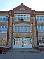
The Grand Island Senior High School.
-
The Grand Island United States Post Office and Courthouse.
-
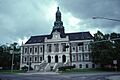
The Hall County Courthouse.
-
The Hamilton-Donald House.
-
The Andrew M. Hargis House.
-
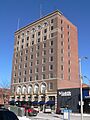
The Hotel Yancey.
-
A building from the Lee Huff Apartment Complex.
-
The Liederkranz building.
-
A section of the Lincoln Highway-Grand Island Seedling Mile.
-
The Nine Bridges Bridge.
-
The Oscar Roeser House.
-
The Shady Bend Gas Station, Grocery, and Diner.
-
The Stolley Homestead Site.
-
The Stuhr Museum of the Prairie Pioneer.
-
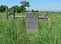
A marker at the Townsley-Murdock Immigrant Trail Site.

_cathedral_interior_1.JPG)


_4.jpg)


