
National Register of Historic Places listings in Hancock County, Kentucky facts for kids

Did you know that some buildings and places are so important to history that they get a special spot on a national list? This list is called the National Register of Historic Places. It helps protect old buildings, sites, and objects across the United States. These places tell us stories about the past and how people lived long ago.
In Hancock County, Kentucky, there are 12 special places listed on the National Register. These include old houses, a courthouse, a church, and even a whole historic neighborhood! By learning about them, we can understand more about the history of Hancock County and the people who lived there.
Contents
- Historic Places in Hancock County
- Robert C. Beauchamp House
- Hancock County Courthouse
- Hawesville Historic District
- Isaac R. Hayden House
- Tom Henderson House
- Immaculate Conception Church
- Jeffry Cliff Petroglyphs (15HA114)
- Lewisport Masonic Lodge
- Samuel Pate House
- Horace Patterson House
- Joe Pell Building
- J.B. Taylor and Son Feed Store
- Images for kids
Historic Places in Hancock County
Here are some of the interesting historic places you can find in Hancock County:
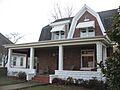
Robert C. Beauchamp House
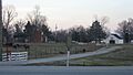
This historic house is located northwest of Hawesville along U.S. Route 60. It was added to the National Register of Historic Places on July 6, 1976. This old home gives us a peek into how people lived in the past.
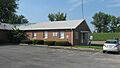
Hancock County Courthouse
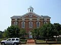
The Hancock County Courthouse is right in the center of Hawesville, on Courthouse Square. This important building was listed on June 18, 1975. Courthouses are often very old and have seen many important events happen over the years.
Hawesville Historic District
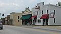
A "historic district" is not just one building, but a whole area with many old and important buildings. The Hawesville Historic District includes parts of Main, River, Main Cross, and Clay Streets in Hawesville. This district was recognized on April 12, 1984. It helps preserve the historic look and feel of the town.
Isaac R. Hayden House
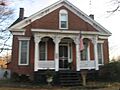
You can find the Isaac R. Hayden House on Pell Street in Lewisport. This house became a historic listing on August 1, 1984. It's another example of the beautiful old homes in the county.
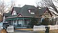
Tom Henderson House
The Tom Henderson House is located on 4th Street in Lewisport. It was also added to the National Register on August 1, 1984. Imagine the families who lived here and the stories these walls could tell!
Immaculate Conception Church
The Immaculate Conception Church was once on River Street in Hawesville. It was listed on June 18, 1975. Sadly, this historic church has since been destroyed.
Jeffry Cliff Petroglyphs (15HA114)
This is a very unique historic site! Petroglyphs are ancient drawings or carvings made on rocks. These specific ones are found near Indian Lake. They were added to the National Register on September 8, 1989. Because they are so old and special, their exact location is kept secret to protect them.
Lewisport Masonic Lodge
The Lewisport Masonic Lodge is on 4th Street in Lewisport. It was listed on August 1, 1984. Lodges like this were often important meeting places for community groups in the past.
Samuel Pate House
The Samuel Pate House is located east of Lewisport, off Kentucky Route 334. This historic home was added to the list on December 21, 1978.
Horace Patterson House
Another historic home, the Horace Patterson House, is on Market Street in Lewisport. It was listed on August 1, 1984.
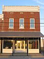
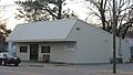
Joe Pell Building
The Joe Pell Building can be found on Pell Street in Lewisport. This building was recognized as historic on August 1, 1984. Old buildings like this often housed businesses or shops that were important to the town.
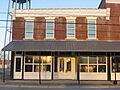
J.B. Taylor and Son Feed Store
The J.B. Taylor and Son Feed Store is located at 307 4th Street in Lewisport. It was added to the National Register on August 1, 1984. This old feed store reminds us of a time when local businesses were central to daily life.
Images for kids
-
The Robert C. Beauchamp House
-
The Hancock County Courthouse
-
Buildings in the Hawesville Historic District
-
The Isaac R. Hayden House
-
The Tom Henderson House
-
The former Immaculate Conception Church building
-
The Lewisport Masonic Lodge
-
The Horace Patterson House
-
The Joe Pell Building
-
The J.B. Taylor and Son Feed Store


