
National Register of Historic Places listings in Hancock County, Maine facts for kids

Welcome to Hancock County, Maine! This area is full of amazing historical places that are so important, they've been added to a special list called the National Register of Historic Places. Think of it like a hall of fame for buildings, sites, and objects that tell us about America's past.
In Hancock County, there are 130 places on this list, including two very special ones called National Historic Landmarks. These landmarks are extra important because they represent big moments in American history. A few other places were once on the list but have since been removed, often because they were changed or no longer exist. Let's explore some of these cool historic spots!
Contents
Historic Places in Hancock County
Bar Harbor Area
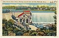
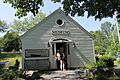
- Robert Abbe Museum of Stone Antiquities: This museum in Bar Harbor shows us ancient tools and artifacts made of stone. It helps us learn about the people who lived here long, long ago.
- Blackwoods Campground: Located in Acadia National Park, this campground is a historic spot. It was designed to help people enjoy nature and has been a popular place for camping for many years.
- Church of Our Father: Found north of Crooked Road, this church is a historic building that has served the community for a long time.
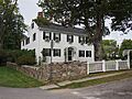
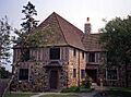
- Cleftstone: This historic building on Eden Street in Bar Harbor is a significant part of the town's past.
- Cover Farm: This farm, located off State Route 3, is a historic district that shows how farms used to look and operate in the area.
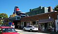
- Criterion Theatre: On Cottage Street, this old theater is a beautiful example of classic movie houses. It has been a place for entertainment for decades.
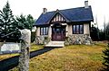
- Eegonos: This unique building on Eden Street in Bar Harbor is another historic property.
- The Farm House: Located on Highbrook Road, this house is a historic part of Bar Harbor's architecture.
- Highseas: Built in 1912, this grand building on Schooner Head Road was once a private summer home. Today, it's a residence hall for The Jackson Laboratory, a famous research center.
- Hulls Cove High School: This former high school building on State Route 3 is a historic landmark in Hulls Cove.
- Jesup Memorial Library: On Mt. Desert Street, this library is a beautiful and historic building that has been a center for learning and community for many years.
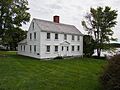
- John Innes Kane Cottage: This cottage on Hancock Street is a historic home that tells a story about the area's past residents.
- Nannau: Located on Lower Main Street, Nannau is another historic property in Bar Harbor.
- Harbor Lane-Eden Street Historic District: This area includes parts of Harbor Lane and Eden Street, featuring many historic buildings that show the old style of Bar Harbor.
- Redwood: This historic property on Barberry Lane is another important part of Bar Harbor's heritage.
- Reverie Cove: On Harbor Lane, Reverie Cove is a historic property that adds to the charm of Bar Harbor.
- St. Edward's Convent (Former): This building on Ledgelawn Avenue was once a convent and is now recognized for its historical importance.
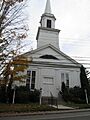
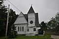
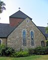
- Saint Saviour's Episcopal Church and Rectory: On Mt. Desert Street, this church and its rectory are historic buildings with beautiful architecture.
- Sproul's Cafe: Located on Main Street, Sproul's Cafe is a historic spot that has been a part of Bar Harbor's downtown for a long time.
- Stone Barn Farm: At the junction of Crooked Road and Norway Drive, this farm in Salsbury Cove is a historic district.
- The Turrets: This building on Eden Street is known for its unique architecture, featuring turret-like towers.
- US Post Office-Bar Harbor Main: On Cottage Street, this post office building is a historic example of public architecture.
- West Street Historic District: This district includes West Street between Billings Avenue and Eden Street, showcasing many historic buildings.
Blue Hill Area
- Barncastle: Located on South Street in Blue Hill, this building is a historic property.
- Blue Hill Historic District: This district includes areas around State Routes 15, 172, 176, and 177. It's a collection of historic buildings that show the town's past.
- Jonathan Fisher Memorial: Southwest of Blue Hill on State Route 15, this memorial honors Jonathan Fisher, an important historical figure in the area.
- East Blue Hill Library: On Milliken Road, this library is a historic building that has served the East Blue Hill community.
- East Blue Hill Post Office: Located on Curtis Cove Road, this post office is another historic building in East Blue Hill.
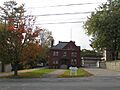
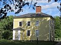
- Ward Hinckley House: This house in Blue Hill is a historic property.
- John Peters House: Located off State Route 176, this house is a historic part of Blue Hill.
- Parker House: On South Street, the Parker House is a historic building in Blue Hill.
Bucksport Area
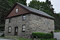
- Brown-Pilsbury Double House: This house on Franklin Street is a historic example of a double house.
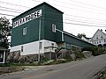
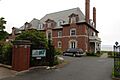
- Buck Memorial Library: On Maine Street, this library is a historic building.
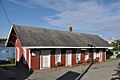
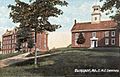
- Bucksport Railroad Station: Located on Main Street, this old train station is a reminder of the town's railway history.
- Elm Street Congregational Church and Parish House: At the junction of Elm and Franklin Streets, this church and its parish house are historic buildings.
- James Emery House: This house on Main Street is a historic property in Bucksport.
- Jed Prouty Tavern and Inn: On Main Street, this historic tavern and inn has been a landmark for many years.
- Wilson Hall: On Franklin Street, Wilson Hall is a historic building in Bucksport.
Castine Area
- Bowdoin (Arctic schooner): This historic ship, the BOWDOIN, is located at the Maine Maritime Academy. It's a special kind of ship called an Arctic schooner, designed for cold waters. It's also a National Historic Landmark!
- Castine Historic District: This large district is roughly bounded by the Bagaduce and Penobscot rivers. It's filled with historic buildings that tell the story of Castine, a very old town.
- Cate House: At the corner of Court and Pleasant Streets, the Cate House is a historic building in Castine.
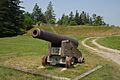
- Fort George: On Wadsworth Street, Fort George was a British fort during the American Revolution. It was the site of the Penobscot Expedition, a big battle during the war.
- Off-the-Neck Historic District: This district on State Route 166 is another area in Castine with many historic buildings.
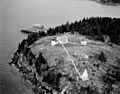
- Pentagoet Archeological District: Located at Perkins Street and Pentagoet Lane, this area is important for its archaeological findings, showing us about early settlements. It's also a National Historic Landmark!
- John Perkins House: On Perkins Street, this house is a historic building in Castine.
Deer Isle Area
- Squire Ignatius Haskell House: On Main Street, this house is now known as Pilgrim's Inn and is a historic part of Deer Isle.
- Haystack Mountain School of Crafts: This school on Haystack School Drive is a historic place for arts and crafts education.
- Pond Island Archeological District: Pond Island is important for its archaeological sites, which reveal information about ancient cultures.
- Peter Powers House: At the intersection of State Route 15 and Sunshine Road, this house is a historic property in Deer Isle.
- Salome Sellers House: South of Deer Isle on State Route 15A, this house is now the museum for the Deer Isle-Stonington Historical Society.
- Frederick Law Olmsted Summer Home: Southwest of Sunset on Deer Isle, this was the summer home of a famous landscape architect.
- Stonington Opera House: At the corner of Main and School Streets, this opera house is a historic venue for performances.
Ellsworth Area
- Agassiz Bedrock Outcrop: On State Street, this rock formation is a historic geological site.
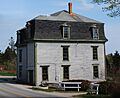
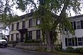
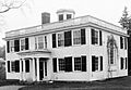
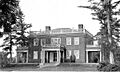
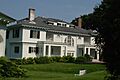
- Black Mansion: On West Main Street, this mansion is a grand historic home.
- Col. Charles and Mary Ann Jarvis Homestead: On Surry Road, this homestead is a historic property in Ellsworth.
- Col. Meltiah Jordan House: On State Street, this house now holds the Ellsworth Public Library and is a historic building.
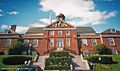
- Ellsworth City Hall: Located at City Hall Plaza, this building is a historic part of Ellsworth's government.
- Ellsworth Congregational Church: On State Street, this church is a historic religious building.
- Ellsworth Power House and Dam: On the Union River, this power house and dam are historic structures related to the town's power supply.
- Hancock County Jail: On State Street, this old jail building is a historic landmark.
- Old Hancock County Buildings: On Court Street, these buildings are a historic part of the county's past.
- The Grand: Located on Main Street, The Grand is a historic theater and building complex.
- Stanwood Homestead: On High Street, this homestead is now the Birdsacre Sanctuary, a place for birds.
Lighthouses and Islands
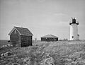
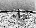
- Baker Island Light Station: On Baker Island in Acadia National Park, this was the first lighthouse for Mount Desert Island, built in 1828. The current tower and keeper's house are from 1855.
- Bass Harbor Head Light Station: At Bass Harbor Head, this lighthouse is a famous landmark.
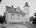
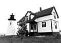
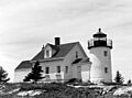
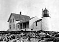
- Bear Island Light Station: On Bear Island in Acadia National Park, this lighthouse was built in 1839. The current tower is from 1889.
- Burnt Coat Harbor Light Station: At Hockamock Head on Swans Island, this lighthouse is a historic coastal guide.
- Egg Rock Light Station: On Egg Rock in Frenchman Bay, this lighthouse is a historic beacon.
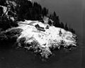
- Great Duck Island Light Station: At the southern tip of Great Duck Island, this lighthouse is an important navigational aid.
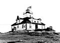
- Mount Desert Light Station: On Mount Desert Rock, this lighthouse now serves as a research station for the College of the Atlantic.
- Prospect Harbor Light Station: At Prospect Harbor Point, this lighthouse helps guide ships.
- Pumpkin Island Light Station: On Pumpkin Island in Eggemoggin Reach, this lighthouse is a historic landmark.
- Winter Harbor Light Station: On Mark Island, this lighthouse is a historic part of Winter Harbor.
Other Historic Places
- Bass Harbor Memorial Library: On Bernard Road in Tremont, this library is a historic building.
- Brick School House: On School House Hill in Aurora, this old schoolhouse is a historic building.
- Brooklin IOOF Hall: On State Route 175, this hall is a historic meeting place.
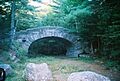
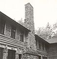
- Carriage Paths, Bridges and Gatehouses: In Acadia National Park, these scenic roads, bridges, and gatehouses were built by John D. Rockefeller Jr. for car-free enjoyment. They are now open to everyone for walking and biking.
- Dix Family Stable: On State Route 102A in Bass Harbor, this stable is a historic structure.
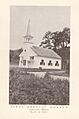
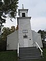
- Eastbrook Baptist Church and Eastbrook Town House: On State Route 200 in Eastbrook, these buildings are a historic pair.
- Edgecliff: On Norwood Lane in Southwest Harbor, Edgecliff is a historic property.
- Fernald Point Prehistoric Site: At Fernald Point in Southwest Harbor, this site is important for understanding ancient history.
- First Baptist Church (East Lamoine): On Lamoine Beach Road, this church is a historic building.
- First Baptist Church (Sedgwick): Off State Route 172, this church is a historic religious building.
- Flye Point 2: This site in Brooklin is a restricted archaeological area.
- Free Baptist Church of Great Pond: On Great Pond Road, this church is a historic building.
- Garland Farm: On State Route 3 in Bar Harbor, this farm is a historic district.
- Gavin Watson Site: This site in Sullivan is a restricted archaeological area.
- Daniel Coit Gilman Summer Home: Off Huntington Road in Northeast Harbor, this was the summer home of an important historical figure.
- Goddard Site: This site in Brooklin is a restricted archaeological area.
- Granite Store: On U.S. Route 1 in Sullivan, this store is a historic building made of granite.
- Edward J. Hammond Hall: On Main Street in Winter Harbor, this hall is a historic building.
- Hancock Point School: On Point Road in Hancock, this school is a historic building.
- Higgins Barn: On Oak Hill Road in Indian Point, this barn is a historic agricultural building.
- Islesford Historical Museum and Blue Ducks Ships Store: On Little Cranberry Island, this museum and store are historic parts of the island's heritage.
- Lucerne Inn: On Bar Harbor Road (U.S. Route 1A) in Dedham, this inn is a historic lodging place.
- Moore-Mayo House: On Lighthouse Road in Bass Harbor, this house is a historic property.
- Nazi Spy Landing Site: On the western shore of Crabtree Neck, this site is where two German spies, Erich Gimpel and William Colepaugh, landed in 1944 during World War II.
- Raventhorp: On Greening Island in Southwest Harbor, Raventhorp is a historic property.
- Robertson Quarry Galamander: On State Route 182 in West Franklin, this is a very rare, special wagon used for moving large stones from quarries. It's one of only two known to still exist in Maine!
- Rural Hall: On Surry Road in Surry, this hall is a historic building.
- Saint Jude's Episcopal Church: On State Route 3 in Seal Harbor, this church is a historic religious building.
- St. Mary's-By-The-Sea: On South Shore Road in Northeast Harbor, this church is a historic religious building.
- Schoodic Peninsula Historic District: South of State Route 186 in Winter Harbor, this district is a historic part of Acadia National Park.
- Sea Change: On Corning Way in Northeast Harbor, Sea Change is a historic property.
- Seal Harbor Congregational Church: On State Route 3 in Seal Harbor, this church is a historic religious building.
- Seawall Campground: On State Route 102A in Southwest Harbor, this campground is a historic part of Acadia National Park.
- Sedgwick Historic District: At the junction of State Route 172 and Old County Road, this district contains many historic buildings.
- Shore Acres: On Lamoine Beach Road in Lamoine Beach, Shore Acres is a historic property.
- Eric E. Soderholtz Cottage: Off State Route 186 in West Gouldsboro, this cottage is a historic building.
- Somesville Historic District: This district includes Somes Harbor and its surroundings in Mount Desert, showcasing many historic buildings.
- Sorrento Library: On Waukeag Avenue in Sorrento, this library is a historic building.
- Surry Town Hall: On Surry Road, this town hall is a historic building.
- Topside: On the northern bank of Walker Pond in Brooksville, Topside is a historic property.
- Union Church of Northeast Harbor: On Summit Road, this church is a historic religious building.
- U.S. Naval Radio Station- Apartment Building and Power House: Located in the Schoodic Peninsula unit of Acadia National Park, these buildings were part of a former U.S. Naval Radio Station.
- Von Mach Site (ME 151/02): This site in Brooksville is a restricted archaeological area.
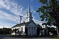
- West Brooksville Congregational Church: On State Route 176, this church is a historic religious building.
- West Gouldsboro Union Church: On State Route 186, this church is a historic building.
- West Gouldsboro Village Library: Also on State Route 186, this library is a historic building.
- E. B. White House: On State Route 175 in Brooklin, this was the home of the famous author E. B. White, who wrote Charlotte's Web and Stuart Little.
- Samuel Kidder Whiting House: On Main Street in Ellsworth, this house is a historic property.
Former Historic Places
Sometimes, places are removed from the National Register of Historic Places. This can happen if they are torn down, or if they change so much that they no longer meet the rules for being a historic site. Here are a few places in Hancock County that were once on the list:
- Atlantic Schoolhouse: This schoolhouse on Swans Island was removed from the list in 2010.
- Waldo-Hancock Bridge: This large bridge on U.S. Route 1 was taken off the list in 2013 because it was demolished. It used to connect Hancock County with Waldo County.
- Wickyup: This summer home near East Sullivan belonged to the famous explorer Richard E. Byrd. Sadly, it was destroyed by a fire in 1984 and removed from the list in 1986.
Images for kids
-
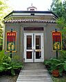
Robert Abbe Museum of Stone Antiquities
-
Baker Island Light Station
-

Bass Harbor Head Light Station
-
Bear Island Light Station
-
Black Mansion
-
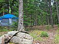
Blackwoods Campground
-
Blue Hill Historic District
-

The schooner BOWDOIN
-
Brooklin IOOF Hall
-
Buck Memorial Library
-
Bucksport Railroad Station
-
Burnt Coat Harbor Light Station
-
One of Acadia National Park's historic carriage road bridges
-
Castine Historic District
-
Cate House
-
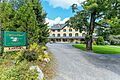
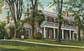
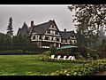
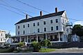
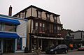
Claremont Hotel
-

Eegonos
-
Egg Rock Light Station
-
Ellsworth City Hall
-

Ellsworth Congregational Church
-
Ellsworth Power House and Dam
-
Elm Street Congregational Church and Parish House
-
First Baptist Church (East Lamoine)
-
Fort George
-
The Grand
-
Granite Store
-
Great Duck Island Light Station
-
Hancock County Jail
-
John Perkins House
-
Jonathan Fisher Memorial
-
Col. Meltiah Jordan House
-
John Innes Kane Cottage
-
Mount Desert Light Station
-
Parker House
-
Pentagoet Archeological District
-
Prospect Harbor Point Light Station
-
Jed Prouty Tavern and Inn
-
Pumpkin Island Light Station
-
Reverie Cove
-
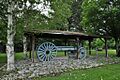
Robertson Quarry Galamander
-
Somesville Historic District
-
Sproul's Cafe
-
Stonington Opera House
-
Surry Town Hall
-
U.S. Naval Radio Station- Apartment Building and Power House
-
West Gouldsboro Union Church
-
West Gouldsboro Village Library
-
West Street Historic District
-
Wilson Hall
-
Winter Harbor Light Station
-

Waldo-Hancock Bridge (former listing)
-
Wickyup (former listing)
-
Saint Saviour's Episcopal Church and Rectory

.jpg)


.jpg)


.jpg)


_Lighthouse_(1892_version)_Maine.JPG)


