
National Register of Historic Places listings in Hudson County, New Jersey facts for kids

Hudson County, New Jersey, is home to many special places listed on the National Register of Historic Places. This is an official list of buildings, sites, and objects that are important to American history and culture. These places are recognized for their unique stories and how they helped shape the past.
This list includes many different types of historic sites. You'll find old fire stations, churches, famous buildings, and even entire neighborhoods. Each one has a unique history that tells us more about Hudson County and the people who lived there.
Contents
Historic Places in Hudson County
Here are some of the interesting historic places you can find in Hudson County:
Bayonne
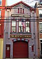
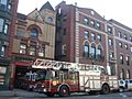
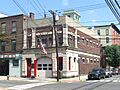
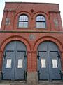
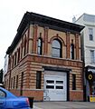
- Bayonne Truck House No. 1 (12 W. 47th St.): This old fire station is now the Bayonne Firefighters Museum. It was listed on January 2, 1976.

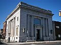
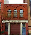
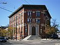
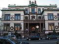
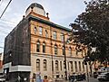
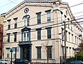
- Bayonne Trust Company (229–231 Broadway): This building, listed on August 8, 2006, is now the Bayonne Community Museum.

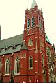
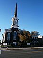
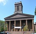
- First Reformed Dutch Church of Bergen Neck (Avenue C and 33rd St.): This historic church was added to the list on April 22, 1982.

- Hale-Whitney Mansion (100 Broadway): A beautiful old mansion listed on June 7, 1996.

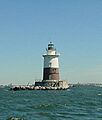
- Robbins Reef Light Station (Southwest Upper New York Bay): This lighthouse, listed on July 19, 2006, is located in the water near Bayonne.

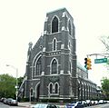
- St. Vincent de Paul Roman Catholic Church (979 Ave. C): This church was added to the list on August 24, 2011.

East Newark
- Clark Thread Company Historic District (900 Passaic Ave.): This area, listed on June 2, 1978, was once home to a large thread factory.

Hoboken
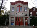
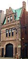
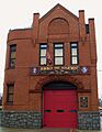
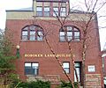
- Association of Exempt Firemen Building (213 Bloomfield St.): This building, listed on March 30, 1984, is part of a group of historic firehouses in Hoboken. It's now the Hoboken Firefighters Museum.

- Buildings at 1200–1206 Washington Street (1200–1206 Washington St.): Also known as The Yellow Flats, these buildings were listed on March 9, 1987.

- Church of Our Lady of Grace (400 Willow Ave.): This church was listed on May 31, 1996.

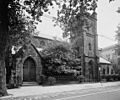
- Church of the Holy Innocents (Willow Ave. and 6th St.): This church was added to the list on May 24, 1977.
.jpg)
- Engine Company No. 2 (1313 Washington St.): Listed on March 30, 1984, this is another historic fire station in Hoboken.

- Engine Company No. 3 (201 Jefferson St.): This fire station was listed on March 30, 1984.

- Engine Company No. 4 (212 Park Ave.): Another historic Hoboken fire station, listed on March 30, 1984.

- Engine Company No. 5 (412 Grand St.): This fire station was listed on March 30, 1984.

- Engine Company No. 6 (801 Clinton St.): Listed on March 30, 1984, this is also part of the historic firehouse group.

- Engine House No. 3, Truck No. 2 (501 Observer Hwy.): This firehouse was listed on March 30, 1984.

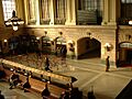
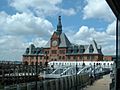
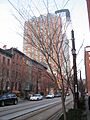
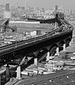
- Erie-Lackawanna Railroad Terminal at Hoboken (Foot of Hudson Pl.): This large train and ferry terminal was listed on July 24, 1973. It's a very important transportation hub.

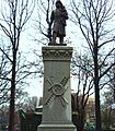
- Firemen's Monument (Church Square Pk.): This monument, listed on October 30, 1986, honors firefighters and is part of the historic firehouse theme.

- First Baptist Church (901–907 Bloomfield St.): This church was added to the list on February 1, 2006.
.jpg)
- Hoboken City Hall (86–98 Washington St.): The city's government building was listed on January 1, 1976.

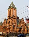
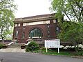
- Hoboken Free Public Library and Manual Training School (500 Park Ave.): This historic library building was listed on August 4, 2015.

- Hoboken Land and Improvement Company Building (1 Newark St.): This building, listed on July 3, 1979, played a role in the development of Hoboken.

- Jefferson Trust Company (313–315 First St.): This former bank building was listed on February 13, 1986.

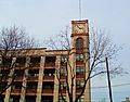
- Keuffel and Esser Manufacturing Complex (3rd, Grand & Adams St.): Once a factory, this complex is now known as Clock Towers and was listed on September 12, 1985.

- Saint Ann's Roman Catholic Church and Rectory (704 Jefferson St.): This church and its rectory were listed on November 24, 2015.

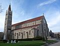
- Edwin A. Stevens Hall (Fifth St. between Hudson and River Sts.): Located at Stevens Institute of Technology, this hall was listed on February 4, 1994.

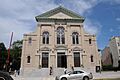
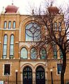
- United Synagogue of Hoboken (115–117 Park Ave): This synagogue was added to the list on June 27, 2008.

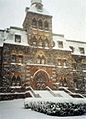
- William Hall Walker Gymnasium (6th St. at Fieldhouse Rd., Castle Point on Hudson): This gymnasium, part of Stevens Institute of Technology, was listed on May 9, 2019.

Jersey City
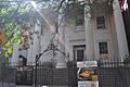
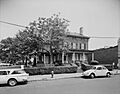
- Dr. William Barrow Mansion (83 Wayne St.): This historic mansion was listed on May 2, 1977.

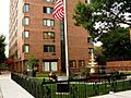
- Fairmount Apartments (2595 Kennedy Blvd.): These apartments were listed on March 3, 1995.

- Ficken's Warehouse (750–766 Grand St.): This old warehouse was listed on June 14, 1984.

- Grace Church Van Vorst (268 2nd St): This church was added to the list on August 1, 1979.

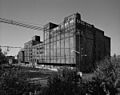
- Great Atlantic and Pacific Tea Company Warehouse (Provost St. between 1st and Bay Sts.): This large warehouse, listed on June 2, 1978, belonged to a famous grocery store chain.

- Hamilton Park Historic District (Roughly bounded by Brunswick, Grove, 6th, and 9th Sts.): This historic neighborhood was listed on January 25, 1979.

- Harsimus Cove Historic District (Roughly bounded by Grove Dr., Bay & First Sts., Jersey Ave., Second, & Coles Sts.): This historic area was listed on December 9, 1987.

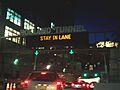
- Holland Tunnel (Connecting Lower Manhattan and Jersey City): This famous underwater tunnel, connecting New Jersey and New York, was listed on November 4, 1993.

- Hook and Ladder No. 3 (218 Central Ave.): This fire station was listed on August 24, 2015.

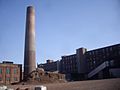
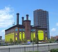
- Hudson and Manhattan Railroad Powerhouse (60–84 Bay St., 344–56 Washington Blvd.): This powerhouse, listed on November 23, 2001, once powered the trains that ran under the Hudson River.

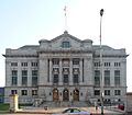
- Hudson County Courthouse (Newark and Baldwin Aves.): This impressive courthouse building was listed on August 25, 1970.

- Jersey City Central Railroad Terminal (U.S. 78 north of Ellis Island): This important train terminal was listed on September 12, 1975. Many immigrants passed through here.

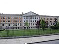
- Jersey City High School (2 Palisade Ave.): Now known as William L. Dickinson High School, this building was listed on June 1, 1982.

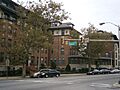
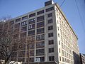
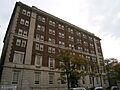
- Jersey City Medical Center (Roughly bounded by Montgomery St., Cornelison Ave., Dupont St., Clifton Pl., and Baldwin Ave.): This former medical center, now called The Beacon, was listed on November 27, 1985.

- Jersey City YMCA (654 Bergen Ave.): This YMCA building was listed on November 12, 1999.

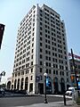
- Labor Bank Building (26 Journal Sq.): This building was listed on June 14, 1984.

- Lembeck and Betz Eagle Brewing Company District (Bounded by 9th, 10th, Grove and Henderson StS.): This historic brewery district was listed on June 21, 1984. The brewery buildings were taken down in 1997.

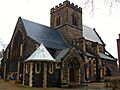
- Old Bergen Church (Bergen and Highland Aves.): This very old church was listed on August 14, 1973.

- Paulus Hook Historic District (Greene, Washington, Grand, Sussex, Morris, Essex, Warren and York Sts.): This historic neighborhood was listed on June 21, 1982.

- Pohlmann's Hall (154 Ogden Ave.): This hall was listed on September 5, 1985.

- Reservoir No. 3 (Bounded by Summit, Jefferson, Central & Reservoir Aves.): This old reservoir was listed on August 27, 2012.

- Route 1 Extension (US 1 and 9 milepoint: 51.25-54.55, NJ 139 milepoint 0-1.45): This includes the famous Pulaski Skyway, listed on August 12, 2005.

- St. Anthony of Padua Roman Catholic Church (457 Monmouth St.): This church was listed on March 22, 2004.

- St. Patrick's Parish and Buildings (Grand St., Ocean and Bramhall Aves.): This church and its buildings were listed on September 17, 1980.

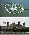
- Statue of Liberty National Monument, Ellis Island and Liberty Island (Upper New York Bay): This world-famous monument, including Ellis Island, was listed on October 15, 1966.

- Van Vorst Park Historic District (Roughly bounded by Railroad Ave., Henderson, Grand, Bright, and Monmouth Sts.): This historic park area was listed on March 5, 1980.

- Van Wagenen House (298 Academy St.): This historic house was listed on August 16, 2006.

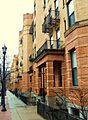
- West Bergen-East Lincoln Park Historic District (Roughly bounded by Bergen, Harrison, West Side, Kensington & Fairmount Aves., Kennedy Blvd. & Montgomery St.): This historic neighborhood was listed on July 19, 2016.

Kearny
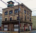
- Highland Hose No. 4 (72–74 Halstead St.): This fire station was listed on May 29, 1987.

Union City
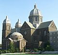
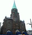
- Monastery and Church of Saint Michael the Archangel (2019 West St.): This monastery and church were listed on March 6, 1986.

Weehawken
- Hackensack Water Company Complex (4100 Park Ave.): This complex, including the Weehawken Water Tower, was listed on January 3, 1980.

Other Historic Listings
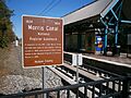
- Morris Canal (Irregular line beginning at Phillipsburg and ending at Jersey City): This historic canal, which once stretched across New Jersey, was listed on October 1, 1974.

Former Listings
Sometimes, a place might be removed from the National Register of Historic Places. This can happen if the building is changed too much, or if it is torn down.
- Seamen's Mission (60-64 Hudson St., Hoboken): This building was listed on July 25, 1978, but was later delisted.
Images for kids
-
Association of Exempt Firemen Building
-
Barrow Mansion in Jersey City
-
Bayonne Fire Museum
-
Bayonne Community Museum
-
Buildings at 1200–1206 Washington Street
-
Church of Our Lady of Grace
-
Church of the Holy Innocents (Hoboken, New Jersey)
-
Clark Thread Company Historic District
-
Engine Company No. 2
-
Engine Company No. 3
-
Engine Company No. 4
-
Engine Company No. 5
-
Engine Company No. 6
-
Engine House No. 3, Truck No. 2
-
Hoboken Terminal waitingroom
-
Fairmount Apartments
-
Ficken's Warehouse
-
Firemen’s Monument Hoboken NJ
-
First Baptist Church (Hoboken, New Jersey)
-
Reformed Church of Bergen Neck
-
Grace Church Van Vorst
-
Great Atlantic and Pacific Tea Company Warehouse
-
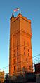
Weehawken Water Tower
-
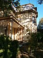
Whitney-Hale Mansion
-
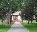
Hamilton Park gazebo
-
PRFountain
-
Highland Hose 4
-
Hoboken City Hall
-
HOBOKEN FREE PUBLIC LIBRARY AND MANUAL TRAINING SCHOOL, HUDSON COUNTY, NJ
-
Hoboken Land and Improvement Company Building
-
Holland Tunnel NY Side
-
HOOK AND LADDER NO 3, JERSEY CITY, HUDSON COUNTY NJ
-
Powerhouse yellow doors fr HBLR crop jeh
-
BrennanCourthouse retouched
-
Jefferson Trust Company
-
CRRNJ Terminal, Liberty State Park, Jersey City NJ
-
Dickenson High JC jeh
-
JCMC old fr SI Ferry jeh
-
JC YMCA
-
Keuffel and Esser Manufacturing Complex
-
26JournalSquare
-
The Lembeck and Betz Eagle Brewing Company
-
8.14.09StMichaelsMonasteryByLuigiNovi
-
Morris Canal marker at Richard Street HBLR
-
Old Bergen Church JC jeh
-
PaulusHook
-
Pohlmann's Hall
-
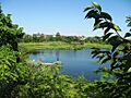
Jcres
-
Robbinsreef2003
-
Pulaski Skyway Kearny ramp
-
ST. ANN ROMAN CATHOLIC CHURCH, HOBOKEN, HUDSON COUNTY NJ
-
Anthony Padua RCC JC jeh
-
Patrick RCC Ocean jeh
-
Vincent de Paul RCC Av C 46 jeh
-
Liberty and Ellis Island
-
Stevens in the snow
-
United Synagogue of Hoboken
-
Van Vorst Park-JC Main Library
-
Van Wagenen House 1933
-
Walker Gymnasium Stevens Tech 2017
-
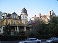
BergenAve Victorians
See also
 In Spanish: Anexo:Registro Nacional de Lugares Históricos en el condado de Hudson para niños
