
National Register of Historic Places listings in Hunterdon County, New Jersey facts for kids

Welcome to Hunterdon County, New Jersey! This area is full of amazing history, and many of its special places are on a list called the National Register of Historic Places. This is like a VIP list for buildings, areas, and structures that are important to American history and culture. When a place is on this list, it means it's recognized as valuable and efforts are made to protect it for future generations.
Hunterdon County has many cool spots on this list, from old farmhouses and mills to entire historic towns. Let's explore some of these fascinating places!
Historic Towns and Neighborhoods
Many towns and parts of towns in Hunterdon County are recognized for their unique history and old buildings. These "historic districts" let you step back in time.
- Amsterdam Historic District (Amsterdam): This area includes Amsterdam, Church, and Crab Apple Hill roads. It's a snapshot of how communities used to look.
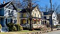
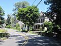
- Annandale Historic District (Annandale): Explore the heart of Annandale, roughly bounded by Maple Avenue, Main Street, Beaver Avenue, and East Street.
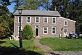
- Asbury Historic District (Bethlehem Township): Found mainly in Asbury, this district includes County Routes 632 and 643, Maple Avenue, Kitchen Road, and School Street.
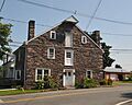
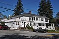
- Califon Historic District (Califon): This charming district covers Main, Academy, Mill, Bank, and First streets, plus Railroad and Philhower avenues and River Road.
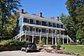
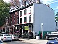
- Clinton Historic District (Clinton): Discover the historic center of Clinton, including Center, West Main, Main, East Main, Halstead, Water, and Leigh streets.
- Clover Hill Historic District (Clover Hill): Located at Amwell and Wertsville-Clover Hill Roads, this district even stretches into Somerset County!
- Cokesbury Historic District (Cokesbury): This area includes Cokesbury-Califon Road, County Route 639, Water Street, and McCatharn Road.
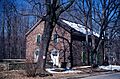
- Covered Bridge Historic District (Delaware Township): This district is special because it includes the famous Green Sergeant's Covered Bridge. It runs along County Route 604, Pine Hill Road, and Lower Creek Road.
- Dart's Mill Historic District (Readington Township): Find this historic spot northeast of Flemington on Route 523.
- Dawlis Mill-Spring Mill Historic District (East Amwell): This district is located at 525 and 530 NJ 31.
- Everittstown Historic District (Everittstown): This district is at the intersection of County Route 513, County Route 519, and Palmyra Road.
- Fairmount Historic District (Tewksbury Township): This district follows NJ 517 and extends into Morris County.
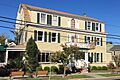
- Flemington Historic District (Flemington): The historic heart of Flemington is roughly bounded by NJ 12, NJ 31, N. Main, Shields, and Hopewell Avenues.
- Frenchtown Historic District (Frenchtown): This district is bounded by 12th Street, Washington Street, the Delaware River, and Nishisakawick Creek, and includes the Uhlerstown–Frenchtown Bridge.
- Headquarters Historic District (Headquarters): Located on Rosemont-Ringoes Road and Zentek Road, this district had its boundaries expanded in 2016.
- Imlaydale Historic District (Hampton): This district is along Imlaydale Road and surrounding land between NJ 31 and the Musconetcong River, extending into Warren County.
- Lambertville Historic District (Lambertville): This vibrant district is found along NJ 29 and NJ 179.
- Lebanon Historic District (Lebanon): Explore Main Street, Cherry Street, Brunswick Avenue, Maple Street, and High Street in Lebanon.
- Little York Historic District (Little York): This district is located at County Route 614 and Sweet Hollow Road.
- Mount Airy Historic District (Lambertville): This area is roughly bounded by NJ 179, Route 605, Route 603, and Route 601.
- Mount Pleasant Historic District (Mount Pleasant): Find this district at County Route 519 and Rick Road.
- Mountainville Historic District (Mountainville): This district includes Main Street, Guinea Hollow, Saw Mill, Rockaway Creek, and Philhower Roads.
- New Hampton Historic District (New Hampton): Roughly along Musconetcong River Road and Rymon Road, this district includes the New Hampton Pony Pratt Truss Bridge.
- New Market-Linvale-Snydertown Historic District (East and West Amwell Townships): This district runs roughly along NJ 31, Linvale, Snydertown, and Woodsville Roads.
- Oldwick Historic District (Oldwick): This charming district is roughly along County Route 517, Church, King, James, Joliet, and William Streets.
- Pittstown Historic District (Pittstown): This district includes Pittstown Road and nearby parts of Race Street and Quakertown Road.
- Pleasant Valley Historic District (West Amwell Township): Centered on the junction of Pleasant Valley Road with Woodens Lane and Hunter Road, this district extends into Mercer County.
- Potterstown Rural Historic District (Potterstown): This district is along Potterstown and Halls Mill Roads and I-78.
- Pottersville Village Historic District (Pottersville): This district includes properties on Black River, Pottersville, McCann Mill, Hacklebarney Roads, Fairmount Road East, and High Street, and extends into Somerset and Morris Counties.
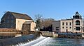
- Prallsville District (Prallsville): Located along NJ 29, this district is home to the historic Prallsville Mills.
- Pursley's Ferry Historic District (Holland Township): This district is found at Old River Road and Church Road.
- Quakertown Historic District (Quakertown): Roughly bounded by Quakertown, Cherryville Roads, Quaker Lane, and Locust Grove Road, this district includes the Quaker Meeting House.
- Raritan–Readington South Branch Historic District (Raritan Township, Readington Township): This district follows River Road from NJ 31 to US 202 and includes the John Reading Farmstead.
- Raven Rock Historic District (Delaware Township): This district is located at NJ 29 and Quarry Road.
- Readingsburg Historic District (Readingsburg): This district includes Cokesbury and Stone Mill Roads, and County Route 639.
- Readington Village Historic District (Readington Township): This district includes Readington, Hillcrest, Centerville, and Brookview Roads, and the Readington Reformed Church.
- Reaville Historic District (Reaville): This district covers Old York, Amwell, Barley Sheaf, Kuhl, and Manners roads.
- Ringoes Historic District (East Amwell Township): This district includes Old York, John Ringo, Wertsville, and Boss Roads, and Larison Lane.
- Rockhill Agricultural Historic District (Union Township): This district is north of Pittstown on SR 513.
- Rosemont Rural Agricultural District (Delaware Township): This district includes County Routes 519 and 604, Sanford Road, and Covered Bridge Road.
- Sand Brook Historic District (Sand Brook): This district is located at County Road 523, Sand Brook-Headquarters, and Britton Roads.
- Sergeantsville Historic District (Delaware Township): This district includes County Routes 523 and 604, Lambert Road, and Delaware Drive.
- Stanton Historic Rural District (Stanton, Readington Township): This district is at the junction of Stanton and Mountain Roads, between Round and Cushetunk Mountains.
- Taylor's Mill Historic District (Readington Township): This district includes Taylor's Mill Road and Rockaway Road.
- Van Syckel Corner District (Union Township): This district is at Van Syckels Corner and Norton Roads.
- Wertsville Historic District (East Amwell Township): This district includes Wertsville and Lindbergh Roads.
- Whitehouse–Mechanicsville Historic District (Readington Township): This district includes Old New Jersey Route 28, Mill, Lamington, and School Roads.
Important Buildings and Structures
Beyond entire districts, many individual buildings and structures in Hunterdon County are also on the National Register. These places often have unique stories or show us how people lived and worked long ago.
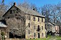
- J. K. Apgar Farmhouse (Califon): This old farmhouse is located at County Route 512 and Guinea Hollow Road.
- Bartles House (Tewksbury Township): You can find this historic house at 159 Oldwick Road.
- Bray-Hoffman House (Annandale): This house is on Bray's Hill Road.
- Case-Dvoor Farmstead (Raritan Township): Located at 111 Mine Street, this farmstead is now the headquarters of the Hunterdon Land Trust.
- Case Farmstead (Pattenburg): This farmstead is west of Pattenburg on SR 14.
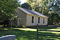
- District No. 98 Schoolhouse (Stockton Borough): This old schoolhouse is at 19 S. Main Street.
- Dunham's Mill (Clinton): Located at 7 Lower Center Street, this mill is now home to the Hunterdon Art Museum.
- Charles Eversole House (Readington Township): This house is at 509 County Road 523.
- Fink-Type Truss Bridge (Clinton Township): This bridge, once west of Allerton off NJ 31 over the South Branch of the Raritan River, has been taken down.
- Frog Hollow Road Bridge over minor tributary of the South Branch, Raritan River (Tewksbury Township): This bridge is on Frog Hollow Road, west of Beavers Road.
- Glen Gardner Pony Pratt Truss Bridge (Glen Gardner): This bridge crosses Spruce Run on School Street.
- Green Sergeant's Covered Bridge (Delaware Township): A beautiful covered bridge on Rosemont-Sergeantsville Road over the Wickecheoke Creek.
- High Bridge Reformed Church (High Bridge): This church is at Church Street and County Route 513.
- Highfields (East Amwell Township): This historic property is at the end of Lindbergh Road.
- Hollow Brook Road Bridge over tributary of the Lamington River (Tewksbury Township): This bridge is on Hollow Brook Road, west of Homestead Road.
- The Kalmia Club (Lambertville): This club is located at 39 York Street.
- Kline Farmhouse (Oldwick): This farmhouse is on NJ 517.
- Lambertville House (Lambertville): A historic building at 32 Bridge Street.
- Lansdown (Pittstown): This property is northeast of Pittstown on Hamden Road.
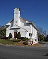
- Locktown Baptist Church (Stockton): This church is west of Stockton on Locktown-Stugeonville Roads.
- James W. Marshall House (Lambertville): This house is at 60 Bridge Street.
- David McKinney Mill (Clinton): Also known as the Red Mill, this mill is at 56 Main Street and is part of the Red Mill Museum Village.
- Mechlin's Corner Tavern (Union Township): This old tavern is northwest of Pittstown.
- Miller Farmstead (Lebanon Township): This historic farm complex and stone arch bridge is primarily in Warren County.
- Mount Salem Methodist Episcopal Church (Alexandria Township): This church is on County Route 579.
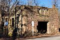
- M. C. Mulligan & Sons Quarry (Clinton): This quarry is at 56 Main Street and is also part of the Red Mill Museum Village.
- Music Hall (Clinton): This historic building is at 23 W. Main Street.
- New Hampton Pony Pratt Truss Bridge (New Hampton): This bridge crosses the Musconetcong River on Shoddy Mill Road and extends into Warren County.
- Old Grandin Library (Clinton): This former library is at 12 E. Main Street.
- Old Stone Presbyterian Church (Kingwood Township): Known as the Old Stone Church, it's at the corner of Oak Summit Road and County Route 519.
- Palatine Road Bridge over a minor tributary of the Lamington River (Tewksbury Township): This bridge is at the junction of Palatine, Homestead, and Cold Spring Roads.
- Peck's Ferry Bridge (Locktown): This bridge is on Locktown-Flemington Road.
- Perryville Tavern (Perryville): This historic tavern is at 167 Perryville Road.
- Raven Rock Road Bridge (Delaware Township): This bridge is on Rosemont-Raven Rock Road.
- John Reading Farmstead (Raritan Township): This farmstead is at 76 River Road.
- Riegel Ridge Community Center (Milford): This center is on County Route 519, north of the New Jersey-Pennsylvania state line.
- St. Thomas Episcopal Church (Alexandria Township): This church is southwest of Pittstown on Sky Manor Road.
- Stone Sign Post Road Bridge over Plum Brook (Delaware Township): This bridge is on Stone Sign Post Road.
- Strimple's Mill Road Bridge over Lockatong Creek (Delaware Township): This bridge is on Strimple's Mill Road.
- Thatcher House (Kingwood Township): This house is at 255 Ridge Road.
- Turner–Chew–Carhart Farm (Union Township): This farm is northwest of Clinton on Van Syckles Road.
- John Van Syckle House (Holland Township): This house is at 195 Rummel Road.
- Christoffel Vought Farmstead (Annandale): This farmstead is east of Grey Rock Road, north of the junction with NJ 31.
- Whitehouse Station (Whitehouse Station, Readington Township): This train station is on Main Street.


,_Flemington_vicinity,_Hunterdon_County_(New_Jersey).jpg)


Images for kids
-
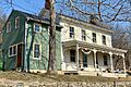
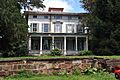
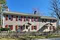
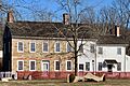
Amsterdam Historic District
-
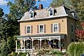
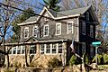
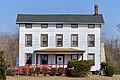
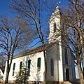
Annandale Historic District
-
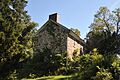
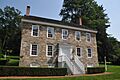
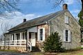
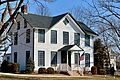
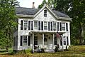
J. K. Apgar Farmhouse
-
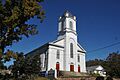
Asbury Historic District
-
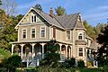
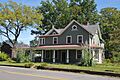
Califon Historic District
-
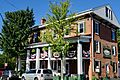
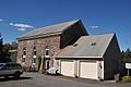
Clinton Historic District
-
Clover Hill Historic District
-
Cokesbury Historic District
-
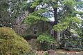
Covered Bridge Historic District
-
Dart's Mill Historic District
-
Dawlis Mill-Spring Mill Historic District
-
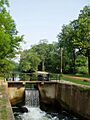
Delaware and Raritan Canal
-
Everittstown Historic District
-
Fairmount Historic District
-
Flemington Historic District
-
Frenchtown Historic District
-
Headquarters Historic District
-
Lambertville Historic District
-
Lebanon Historic District
-
Little York Historic District
-
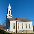
Locktown Baptist Church
-
Mount Airy Historic District
-
Mount Pleasant Historic District
-
Mountainville Historic District
-
New Hampton Historic District
-
New Market-Linvale-Snydertown Historic District
-
Oldwick Historic District
-
Pleasant Valley Historic District
-
Potterstown Rural Historic District
-
Pottersville Village Historic District
-
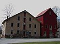
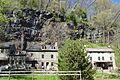
Prallsville District
-
Pursley's Ferry Historic District
-
Quakertown Historic District
-
Raritan–Readington South Branch Historic District
-
Raven Rock Historic District
-
Readingsburg Historic District
-
Readington Village Historic District
-
Reaville Historic District
-
Ringoes Historic District
-
Rockhill Agricultural Historic District
-
Rosemont Rural Agricultural District
-
Sand Brook Historic District
-

Sergeantsville Historic District
-
Stanton Historic Rural District
-
Taylor's Mill Historic District
-
Van Syckel Corner District
-
Wertsville Historic District
-
Whitehouse–Mechanicsville Historic District


