
National Register of Historic Places listings in Idaho County, Idaho facts for kids

Have you ever wondered about the old buildings and special places in your area? Many places in the United States are so important because of their history that they are added to a special list called the National Register of Historic Places. This list helps protect these places so future generations can learn from them.
Idaho County in Idaho has many amazing places on this list. These sites tell us stories about the past, from early settlements and mining towns to important events and the lives of people who lived there long ago. Let's explore some of these cool historic spots!
Contents
Historic Places in Idaho County
Idaho County is home to over 40 places listed on the National Register of Historic Places. These include old homes, unique gardens, ranger stations, and even battlefields. Each one has a special story to tell about the history of Idaho.
Homes and Buildings with History
Many of the places on the list are old homes and buildings that show us how people lived and worked in the past.
The James V. and Sophia Baker House
Located in Cottonwood, the James V. and Sophia Baker House is a beautiful old home built a long time ago. It was added to the National Register in 2004. Imagine what life was like for the Baker family living there!
The Polly Bemis House
The Polly Bemis House is a very special place near Riggins, accessible by boat on the Salmon River. Polly Bemis was a famous Chinese-American pioneer woman who lived in Idaho. Her house, listed in 1988, is a reminder of her incredible life story and the challenges faced by early settlers.
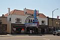
The Blue Fox Theatre
In Grangeville, you can find the Blue Fox Theatre on West Main Street. This theater, listed in 1999, was once a popular spot for people to watch movies and shows. It's a great example of old movie theaters that were once the heart of small towns.
The Dr. Wilson Foskett Home and Drugstore
The Dr. Wilson Foskett Home and Drugstore in White Bird was added to the list in 2005. Dr. Foskett was likely an important person in the community, providing medical care and supplies. This site helps us understand health and daily life in the past.
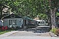
The Riggins Motel
Even motels can be historic! The Riggins Motel in Riggins, listed in 2001, shows us how travel and lodging have changed over the years.
St. Gertrude's Convent and Chapel
West of Cottonwood stands St. Gertrude's Convent and Chapel, a significant religious and historical site listed in 1979. It represents the role of religious communities in the development of the area.
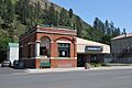
State Bank of Kooskia
The State Bank of Kooskia on South Main Street in Kooskia was added to the list in 1978. This building tells us about the economic history of the town and how people managed their money long ago.
Unique Outdoor and Natural Sites
Idaho County's history isn't just in buildings; it's also found in its beautiful natural landscapes.
Ah Toy Garden, Celadon Slope Garden, and Chi-Sandra Garden
Near Warren, along China Creek, are three unique places: the Ah Toy Garden, Celadon Slope Garden, and Chi-Sandra Garden. These gardens, listed in 1990, are linked to the history of Chinese miners and settlers in the area. They show how people adapted the land for their needs.
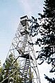
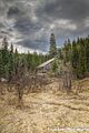
Arctic Point Fire Lookout and Carey Dome Fire Lookout
High up in the forests, the Arctic Point Fire Lookout and Carey Dome Fire Lookout were vital for spotting wildfires. These lookouts, listed in 1994, remind us of the important work done by forest rangers to protect our natural spaces.
Chinese Cemetery and Chinese Mining Camp Archeological Site
Near Warren, you can find the Chinese Cemetery (listed in 1994) and the Chinese Mining Camp Archeological Site (listed in 1994). These sites offer a glimpse into the lives of Chinese immigrants who came to Idaho during the mining boom, helping to build the state.
Elk City Wagon Road-Victory Gulch-Smith Grade Segment
This section of the Elk City Wagon Road, listed in 2001, was an important route for travel and trade. It helps us understand how people moved goods and traveled across the rugged Idaho landscape.
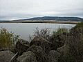
Tolo Lake
Tolo Lake, near Grangeville, is a very important historical site, especially for the Nez Perce National Historical Park. Listed in 2011, this lake played a role in the history of the Nez Perce people. You can learn more about it on the National Park Service website.
Ranger Stations and Administrative Sites
Many ranger stations in Idaho County are also historic, showing the long history of forest management and conservation.
Chamberlain Ranger Station Historic District
The Chamberlain Ranger Station Historic District in the Frank Church-River of No Return Wilderness was listed in 2004. These stations were important bases for forest rangers.
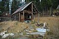
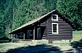
Fenn Ranger Station
The Fenn Ranger Station near Kooskia, listed in 1990, is another example of these historic sites. It shows how forest services have operated for many years.
Lochsa Historical Ranger Station
The Lochsa Historical Ranger Station near Kooskia, listed in 1978, is a significant site that tells the story of early forest management in the region.
Moose Creek Administrative Site
The Moose Creek Administrative Site near Grangeville, listed in 1990, was another important base for managing the vast forests of Idaho.
Warren Guard Station, Building 1206
The Warren Guard Station, Building 1206 near Warren, listed in 1994, also served as a key point for forest protection and administration.
Battlefields and Important Events
Some sites on the National Register mark important historical events.
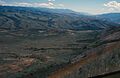
White Bird Battlefield
The White Bird Battlefield north of White Bird, listed in 1974, is where the first battle of the Nez Perce War took place in 1877. It's a solemn place that helps us remember a significant moment in Idaho's history.
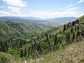
White Bird Grade
The White Bird Grade northeast of White Bird, listed in 1974, is a historic road that was part of the landscape during the Nez Perce War.
Other Interesting Sites
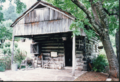
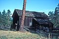
Burgdorf
The small community of Burgdorf, listed in 1972, is about 15 miles west of Warren. It's an old settlement that gives us a peek into what life was like in remote Idaho towns.
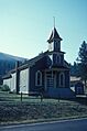
First Presbyterian Church (Kamiah, Idaho)
The First Presbyterian Church southeast of Kamiah, listed in 1976, is an important part of the community's history and religious life.
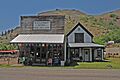
Gold Point Mill
The Gold Point Mill near Elk City, listed in 2000, was part of the mining industry that shaped Idaho. Mills like this processed valuable minerals.
Sue McBeth Cabin
The Sue McBeth Cabin southeast of Kamiah, listed in 1976, is another historic cabin that tells a story about early settlers.
Images for kids
-
Arctic Point Fire Lookout
-
Polly Bemis House
-
Blue Fox Theatre
-
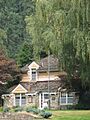
An old home in Burgdorf, Idaho
-
Fenn Ranger Station
-
First Presbyterian Church in Kamiah
-
Dr. Wilson Foskett Home and Drugstore
-
Gold Point Mill
-
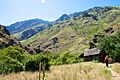
A homestead in Hells Canyon
-
Lochsa Historical Ranger Station
-
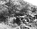
Lower Salmon River Archeological District
-
Sue McBeth Cabin
-
Riggins Motel
-
State Bank of Kooskia
-
Tolo Lake
-
White Bird Battlefield
-
White Bird Grade


