
National Register of Historic Places listings in Lawrence County, Tennessee facts for kids

Welcome to Lawrence County, Tennessee! This article is all about the cool and important places here that are listed on the National Register of Historic Places. Think of the National Register as a special list of buildings, sites, or areas across the United States that are super important because of their history, architecture, or what they mean to our culture.
In Lawrence County, there are 15 different places and areas that have made it onto this special list. These spots help us remember the past and understand how things used to be. Let's take a look at some of them!
Contents
Historic Buildings in Lawrenceburg
Lawrenceburg is the biggest city in Lawrence County, and it has several interesting historic places.
The Crockett Theater
The Crockett Theater is a beautiful old theater located at 205 North Military Avenue. It was added to the National Register in 1997. Imagine all the shows and movies people have watched there over the years! It's a great example of a classic movie house.
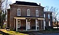
Garrett House
The Garrett House is another historic building in Lawrenceburg, found at 205 South Military Avenue. This house was added to the list in 2009. Old houses like this often have unique designs and stories from the families who lived there long ago.
Lawrence County Jail
Even old jails can be historic! The Lawrence County Jail on Waterloo Street was listed in 1976. This building shows us what jails looked like many years ago and how justice was handled in the past.
Sacred Heart of Jesus Church
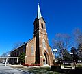
There are two churches named Sacred Heart of Jesus Church on the list in Lawrence County. The one in Lawrenceburg, on Berger Street, was added in 1984. Churches often have amazing architecture and are important community centers.
Lawrenceburg Commercial Historic District
This isn't just one building, but a whole area! The Lawrenceburg Commercial Historic District includes many buildings around North Military Street, Public Square, East Gaines Street, and East Pulaski Street. This district was added in 1992. It's like stepping back in time to see what the main shopping and business area looked like many years ago.
Historic Places Beyond Lawrenceburg
Lawrence County has historic spots all over, not just in the main city!
Mount Zion Methodist Episcopal Church South
Out in Fall River, you can find the Mount Zion Methodist Episcopal Church South on Mount Zion Road. This church became a historic place in 1988. It's a reminder of the important role churches played in rural communities.
Old Natchez Trace
The Old Natchez Trace is a very famous historic path that stretches from Alabama all the way into Davidson County, Tennessee. Part of this ancient trail runs through Lawrence County and was added to the National Register in 1975. For hundreds of years, Native Americans, European settlers, and traders used this path. It's like an old highway that tells stories of travel and trade from long ago.
Sacred Heart of Jesus Church (Loretto)
Another Sacred Heart of Jesus Church is located in Loretto, on Church Street. This one was built in 1912 and was added to the National Register in 1984, just like the one in Lawrenceburg.
St. Joseph Church
In the town of St. Joseph, the St. Joseph Church on Spring Street was also added to the National Register in 1984. These old churches are often beautiful and have a lot of history within their walls.
St. Mary's Cemetery
Cemeteries can also be historic! St. Mary's Cemetery, located off Rascal Town Road, was listed in 1984. Cemeteries are important because they tell us about the people who lived in an area long ago and how they were remembered.
Hydroelectric Stations
Did you know that some old power plants can be historic?
Lawrenceburg No. 1 Hydroelectric Station
The Lawrenceburg No. 1 Hydroelectric Station is located on Glen Spring Road at the Horseshoe Bend of Little Shoal Creek. It was added to the National Register in 1990. Hydroelectric stations use the power of moving water to create electricity, and this one shows how people used to generate power a long time ago.
Lawrenceburg No. 2 Hydroelectric Station
Another power station, the Lawrenceburg No. 2 Hydroelectric Station, is found near Mile 51.7 on Shoal Creek, close to Old U.S. Route 43. This one was listed in 1990 as well. These stations are cool examples of early technology used to bring power to homes and businesses.
Places No Longer on the List
Sometimes, a historic place might be removed from the National Register. This usually happens if the building is destroyed or changed so much that it no longer looks like it did when it was first listed.
Garner Mill
The Garner Mill on Garner Lane in Lawrenceburg was once on the list, added in 1984. However, it was removed in 2008 because it was sadly destroyed by flooding in 1998. It's a reminder that even historic places can be affected by natural events.
These historic places in Lawrence County help us learn about the past and appreciate the unique story of this part of Tennessee!
Images for kids
-
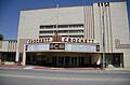
The historic Crockett Theater in Lawrenceburg.
-

The Garrett House.
-
The old Lawrence County Jail.
-
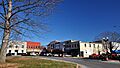
Buildings in the Lawrenceburg Commercial Historic District.
-
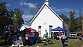
Mount Zion Methodist Episcopal Church South.
-

A section of the Old Natchez Trace.
-
Sacred Heart of Jesus Church in Lawrenceburg.
-

Sacred Heart of Jesus Church in Loretto.

.JPG)


.JPG)

