
National Register of Historic Places listings in Madison County, Kentucky facts for kids

Welcome to Madison County, Kentucky! This page is all about special places here that are listed on the National Register of Historic Places. Think of it like a national list of important buildings, sites, and areas that tell us about America's past. These places are protected because they are part of our history.
In Madison County, there are 81 different places on this list. Two of them are even more special and are called National Historic Landmarks. This means they are super important to the history of the entire United States! Let's explore some of these amazing spots.
Contents
Exploring Historic Places in Madison County
Madison County is full of history, from ancient sites to grand old homes and important battlefields. These places help us understand how people lived long ago and what events shaped our world.
Ancient Sites and Early Settlements
Some of the oldest places on the list are archaeological sites. These are spots where scientists have found clues about people who lived here thousands of years ago.
Archeological Site 15 Ma 24
This site is located near Round Hill. It's a place where archaeologists study ancient cultures. They can learn about early communities and how they lived by carefully digging up artifacts.

Fort Boonesborough State Park
This park is a very important historical site. It's where Daniel Boone and other pioneers built one of the first forts in Kentucky in 1775. It was a key settlement during the early days of Kentucky. Today, you can visit the park and learn about pioneer life.

Historic Homes and Buildings
Many beautiful old houses and buildings in Madison County are on the National Register. They show us different styles of architecture and how people lived in the past.
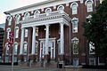
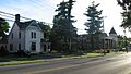
Arlington
Arlington is a historic home in Richmond. It's a beautiful example of old architecture and has been a part of the community for many years.

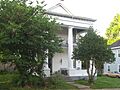
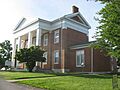
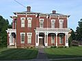
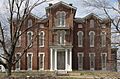
Judge Daniel Breck House
Located in Richmond, this house belonged to Judge Daniel Breck. He was an important figure in Kentucky's history. The house itself is a great example of homes from its time.

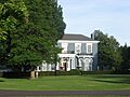
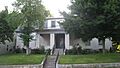
Irvinton
Irvinton is another lovely historic home in Richmond. It stands as a reminder of the past, with its classic design and long history.

William Holloway House
This house on Hillsdale Street in Richmond is also recognized for its historical value. It adds to the rich collection of historic homes in the area.

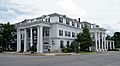
White Hall
White Hall is a grand mansion north of Richmond. It was the home of Cassius Marcellus Clay, a famous politician and abolitionist. This house is so important it's a National Historic Landmark! It's a wonderful place to visit and learn about a significant period in American history.

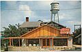
Boone Tavern Hotel
The Boone Tavern Hotel is located in Berea. It's a famous hotel built by Berea College in 1909. It's known for its unique history and for being a place where students from the college used to work.

Churchill Weavers
In Berea, Churchill Weavers was a well-known textile company. This site is important because it represents a part of the region's industrial and craft history.

Important Districts and Public Buildings
Some listings are not just single buildings but entire areas or important public spaces that tell a story.
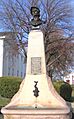
Battle of Richmond Historic Areas
These areas in Richmond mark the site of the Battle of Richmond, a major Civil War battle that happened in 1862. It was one of the biggest Confederate victories in Kentucky. Visiting these areas helps us remember the brave soldiers who fought there.

Downtown Richmond Historic District
The heart of Richmond, including Main Street and Courthouse Square, is a historic district. This means many buildings in this area are old and important. It shows how the town grew over time.

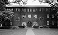
Eastern Kentucky University Historic District
The campus of Eastern Kentucky University in Richmond has its own historic district. This includes some of the oldest and most important buildings on the campus, showing the university's long history in education.

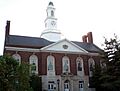
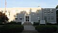
Madison County Courthouse
The Madison County Courthouse in Richmond is a central part of the county's government and history. It's where many important decisions have been made over the years.

Louisville and Nashville Railroad Passenger Depot
This old train station in Berea, located on Broadway, was once a busy place. It reminds us of a time when trains were the main way people traveled and goods were moved.

Richmond Armory
The Richmond Armory is a building that was used by the military. It's a part of the local history of defense and community service.

Union Bus Station
The Union Bus Station in Richmond is a historic spot related to transportation. It shows how bus travel became important for people moving around the country.

Other Notable Sites
Madison County also has other interesting places that are part of its historic register.
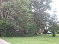
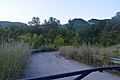
Berea College Forest
This forest, east of the Berea College campus, is recognized for its natural and educational importance. It's a place where students and the community can learn about nature and conservation.

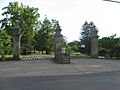
Richmond Cemetery
The Richmond Cemetery on East Main Street is more than just a burial ground. It's a historic site where many important people from Madison County's past are laid to rest. It tells stories of families and community leaders.

Images for kids
-
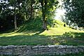
An ancient mound, similar to those found at Archeological Site 15 Ma 24
-
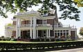
Arlington, a historic home in Richmond
-

A monument at the Battle of Richmond Historic Areas
-
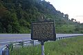
A historical marker near the Berea College Forest
-
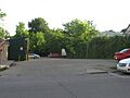
Blair Park in Richmond
-
The historic Boone Tavern Hotel in Berea
-
The Judge Daniel Breck House
-
Bronston Place
-
Burnawood
-
A building at Churchill Weavers
-
A monument in the Downtown Richmond Historic District
-
Keen Johnson Building at Eastern Kentucky University
-
Elmwood in Richmond
-

A drawing of Fort Boonesborough, showing how it might have looked
-
The William Holloway House
-
Irvinton, a historic house in Richmond
-
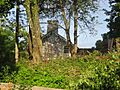
The Merritt Jones Tavern site
-
Lincoln Hall at Berea College
-
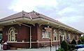
The former Louisville and Nashville Railroad Passenger Depot in Berea
-
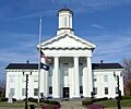
The Madison County Courthouse
-
Mount Pleasant in Richmond
-
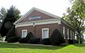
Mt. Zion Christian Church
-
University Building, Eastern Kentucky University
-
The Richmond Armory building
-
The historic gates of Richmond Cemetery
-
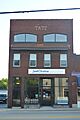
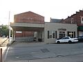
The Tate Building in Berea
-
The Taylor House site in Richmond
-
The Squire Turner House
-
The Union Bus Station in Richmond
-
The Walker House in Richmond
-
Main Street in the West Richmond Historic District
-
White Hall, a National Historic Landmark


.jpg)


